Gelena (Southern Indian Ocean)

Feb. 6, 2019 – NASA Catches Development of Tropical Cyclone Gelena

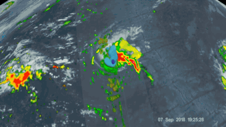
Visible-light imagery from NASA’s Aqua satellite revealed the development of Tropical Depression 13S into a tropical storm. Tropical Storm Gelena intensified rapidly and appeared to have a cloud-filled eye.

At 5:20 a.m. EDT (1020 UTC) on Feb. 6 the Moderate Resolution Imaging Spectroradiometer, or MODIS, instrument aboard NASA’s Aqua satellite provided a visible image of Tropical Storm Gelena in the Southern Indian Ocean. The image showed the storm developing an eye, with bands of thunderstorms wrapping into the low-level center.

image of Gelena
At 5:20 a.m. EDT (1020 UTC) on Feb. 6, 2019, the MODIS instrument aboard NASA’s Aqua satellite provided a visible image of Tropical Storm Gelena in the Southern Indian Ocean. The image showed the storm developing an eye, with bands of thunderstorms wrapping into the low-level center. Credit: NASA/NRL

At 10 a.m. EDT (1500 UTC) on Feb. 6, the Joint Typhoon Warning Center or JTWC noted that Trami had maximum sustained winds near 45 knots (52 mph/83 kph). It was centered near 12.3 degrees south latitude and 53.4 degrees east longitude. That’s 504 nautical miles north-northwest of St. Denis, La Reunion Island.

JTWC has forecast Gelena to strengthen rapidly and will eventually turn to the southeast. It is expected to reach hurricane-strength upon approach to Rodrigues, on Feb. 9.

Rob Gutro
NASA’s Goddard Space Flight Center, Greenbelt, Md.

12S (Southern Indian Ocean)

Feb. 5, 2019 – NASA-NOAA’s Suomi NPP Satellite Catches Development of Tropical Cyclone 12S

Tropical Cyclone 12S has developed east of the African island nation of Madagascar. NASA-NOAA’s Suomi NPP satellite passed over the Southern Indian Ocean and captured a visible image of the newly formed storm that has triggered a warning for Rodrigues, an outer island of the Republic of Mauritius.

Tropical Cyclone 12S
On Feb. 5, 2019, the VIIRS instrument aboard NASA-NOAA’s Suomi NPP satellite captured a visible image of Tropical Cyclone 12S, located northeast of Madagascar, in the Southern Indian Ocean. Credit: NASA Worldview, Earth Observing System Data and Information System (EOSDIS) https://go.nasa.gov/2HRTDhi

On Feb. 5, 2019, the Visible Infrared Imaging Radiometer Suite (VIIRS) instrument aboard NASA-NOAA’s Suomi NPP satellite captured visible image of Tropical Cyclone 12S. VIIRS imagery showed powerful thunderstorms wrapping into the low-level center from a large, thick band of thunderstorms spiraling in from the southern quadrant of the storm. Outer clouds from the western quadrant were just brushing the northeastern coast of Madagascar.

At 10 a.m. EDT (1500 UTC) on Feb. 5 the center of Tropical Storm 12S was located near latitude 15.8 degrees south and longitude 64.3 degrees east. That’s about 492 nautical miles (566 miles/912 km) east-northeast of Port Louis, Mauritius. Maximum sustained winds are near 35 knots (40 mph/65 kph) with higher gusts. The Joint Typhoon Warning Center expects continuous strengthening and 12S is expected to reach hurricane-force by Feb. 7. It is expected to reach peak intensity near 105 knots (121 mph/194 kph) in three days.

A tropical cyclone warning class 1 is in force at Rodrigues. For local forecasts from the Mauritius Meteorological Service, visit: http://metservice.intnet.mu/.

12S is moving southwestward and is forecast to turn to the southeast and move away from Mauritius and La Reunion Islands.

By Rob Gutro
NASA’s Goddard Space Flight Center

Kong-rey (Northwestern Pacific Ocean) 2018

Oct. 05, 2018 -NASA Investigates Tropical Storm Kong-Rey’s Rainfall Rates

The Global Precipitation Measurement mission or GPM core satellite passed over Tropical Storm Kong-Rey and analyzed the rates in which rain was falling throughout the storm.

NASA/JAXA/NRL
The GPM or Global Precipitation Measurement mission core observatory satellite passed above Kong-Rey on Oct. 5. GPM indicated that rain was falling at over 1.8 inches (45.7 mm) per hour within two areas of storms northwest of Kong-Rey’s center. Credit: NASA/JAXA/NRL

At the time GPM passed overhead, GPM’s Microwave Imager (GMI) instruments collected data that revealed moderate convective rainfall northwest of Kong-Rey’s center. GPM indicated that rain was falling at over 1.8 inches (45.7 mm) per hour within two areas of storms northwest of Kong-Rey’s center.

At 5 a.m. EDT (0900 UTC) on Friday, Oct. 5, the center of Tropical Storm Kong-Rey was located near 29.6 degrees north latitude and 125.9 degrees west longitude. Kong-Rey is about 211 nautical miles north-northwest of Kadena Air Base, Okinawa Island, Japan. Maximum sustained winds are near 63 mph (55 knots/102 kph) with higher gusts.

Kong-Rey is moving toward the north. A turn toward the northeast is expected to take the storm into the Sea of Japan. The storm is now weakening, and will become extra-tropical over northern Japan.

Rob Gutro
NASA’ Goddard Space Flight Center

Leslie (Atlantic Ocean) 2018

NASA’s Aqua satellite passed over the Central Atlantic Ocean and obtained infrared data on Leslie, now weakened to a large tropical storm.

The National Hurricane Center or NHC said that Leslie remains a large tropical storm, with tropical-storm-force winds extending outward up to 290 miles (465 km) from the center. Because of the size and strength of Tropical Storm Leslie, waves from Leslie are expected to increase along the coasts of Atlantic Canada and New England today, Oct. 5.

Satellite data on Leslie
At 1:40 a.m. EDT (0540 UTC) on Oct. 5, the MODIS instrument aboard NASA’s Aqua satellite revealed strongest storms with the coldest cloud top temperatures (yellow) northwest of Leslie’s center with temperatures near minus 63 degrees Fahrenheit (minus 53 degrees Celsius). Credit: NASA/NRL

At 1:40 a.m. EDT (0540 UTC) on Oct. 5, the Moderate Resolution Imaging Spectroradiometer or MODIS instrument aboard NASA’s Aqua satellite revealed strongest storms with the coldest cloud top temperatures northwest of Leslie’s center. MODIS found coldest cloud tops had temperatures near minus 63 degrees Fahrenheit (minus 53 degrees Celsius). NASA research has found that cloud top temperatures that cold have the capability to generate heavy rainfall.

At 5 a.m. EDT (0900 UTC), the center of Tropical Storm Leslie was located near 35.9 degrees north latitude and 58.3 degrees west longitude. Leslie is moving toward the north-northwest near 14 mph (22 kph). A slower northward motion is expected to occur today, but Leslie will make a sharp turn toward the east and east-southeast over the weekend.

Maximum sustained winds are near 65 mph (100 kph) with higher gusts.  Little change in strength is forecast during the next several days.

NHC cautioned, “Large swells generated by Leslie will continue to affect portions of the southeastern coast of the United States, Bermuda, the Bahamas, and the Greater and Lesser Antilles during the next few days. Swells are expected to increase near the coasts of New England and Atlantic Canada today.”

For updated forecasts, visit: www.nhc.noaa.gov

Rob Gutro
NASA’ Goddard Space Flight Center

NASA Keeps a Vigilant Eye on Hurricane Florence

On Sept. 7, NASA’s Global Precipitation Measurement, or GPM, core observatory satellite flew over Hurricane Florence, capturing a 3D image as the storm’s clouds started to break apart before reforming. Credits: NASA
NASA’s Earth Science Disaster Program is using the vantage point of space to provide important information to disaster responders before and after Hurricane Florence approaches the Carolinas.

Before the storm makes landfall, the space agency is utilizing data from satellites, such as Soil Moisture Active Passive (SMAP) to home in on areas that are saturated with water and Global Precipitation Measurement (GPM) to track rainfall rates across the body of the storm, in order to help determine which areas are at greater risk for flooding. The potential for landslides are also evaluated by looking at those factors in addition to land topography.

The crew aboard the International Space Station stared down the menacing eye of what was then Category 4 Hurricane Florence on Sept. 12 as it moved across the Atlantic Ocean and toward the East Coast of the United States. Credits: NASA
Astronauts aboard the International Space Station are also taking advantage of their one-of-a-kind vantage point a few hundred miles above Earth as they snap photos of the hurricane with handheld digital cameras. These wide-field, panoramic images help inform the size, scale, and location of the storm based on the ISS orbital ground track location, and multiple images taken over time relays important data on its evolution and life cycle.

As the storm hits the coasts and marches inland, NASA’s continually updated flood extent maps, derived from radar-based satellites that can “see through” clouds, will identify inundated areas, and the latest in flood modeling will anticipate for decision makers where flooding may occur next. This information is important for a number of decisions pertaining to evacuation routes, supply chains, and resource and relief allocation.

To provide situational awareness for first responders and other government authorities, in the storm’s aftermath NASA will maintain flood extent maps drawn from data collected by the Moderate Resolution Imaging Spectroradiometer (MODIS) aboard the Terra and Aqua satellites as well as the Landsat satellite, a joint mission of NASA and the U.S. Geological Survey.

Composite image of the continental U.S. at night, 2016. Credits: NASA Earth Observatory images by Joshua Stevens, using Suomi NPP VIIRS data from Miguel Román, NASA’s Goddard Space Flight Center
Another tool in the recovery effort is NASA Goddard Space Flight Center’s Black Marble product suite, which can report daily on whether the power is on over over large swaths of land. Such information is important for understanding the extent of the damage, especially in remote and isolated areas that might not have robust communications systems in place. The technology was demonstrated during the response and recovery efforts following Hurricanes Irma and Maria in Puerto Rico, as it helped local communities strengthen their resilience by identifying preexisting infrastructure vulnerabilities across the island’s housing, transportation, and energy sectors.

Click here to watch NASA Administrator Jim Bridenstine and NASA Disasters Program Manager David Green discuss how the space agency is assisting federal and state partners in preparing for and responding to Hurricane Florence.

Preparing for Hurricane Florence

Hurricane Florence is expected to bring heavy wind and rain to large parts of the East Coast in the coming days. The federal government released recommendations for how to prepare and evacuate.