Aug. 12, 2019 – NASA Measures Rain Rate in Tiny Tropical Storm Henriette
Tiny Tropical Storm Henriette is the newest addition to the tropical cyclone line-up in the Eastern Pacific Ocean. The storm developed early on Aug. 12 and soon after the GPM satellite passed overhead and found heavy rain happening around its center.
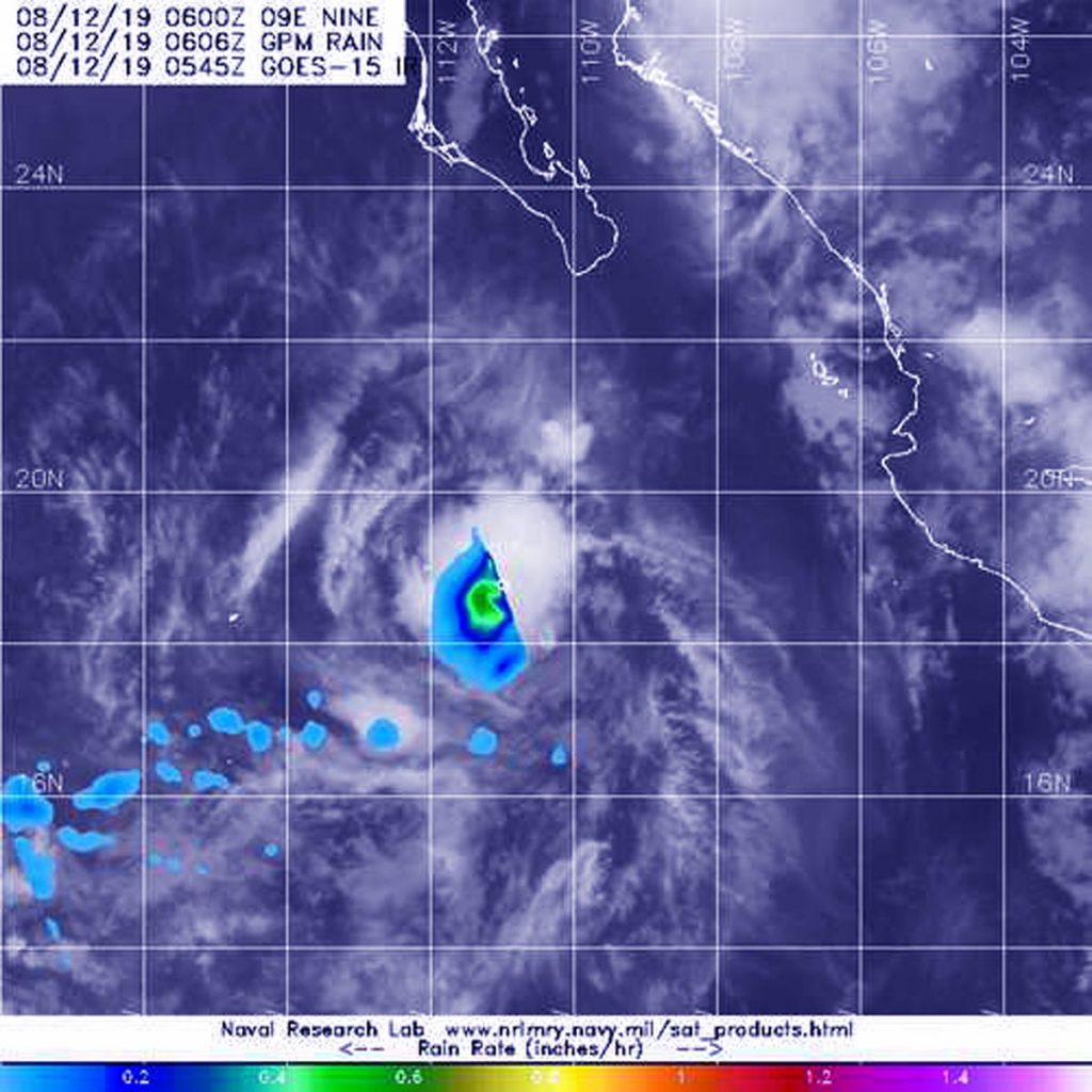
The GPM core satellite passed over Tropical Storm Henriette at 2:06 a.m. EDT (0606 UTC) on August 12, 2019. GPM found the heaviest rainfall (orange) around Henriette’s center of circulation falling at a rate of 25 mm (about 1 inch) per hour. Credit: NASA/JAXA/NRL
The Global Precipitation Measurement mission or GPM core satellite passed over Tropical Storm Henriette at 2:06 a.m. EDT (0606 UTC) on August 12, 2019. GPM found the heaviest rainfall was around the center of circulation falling at a rate of 25 mm (about 1 inch) per hour, over open waters of the Eastern Pacific. GPM is a joint mission between NASA and the Japan Aerospace Exploration Agency, JAXA.
NOAA’s National Hurricane Center (NHC) said, at 11 a.m. EDT (1500 UTC), the center of Tropical Storm Henriette was located near latitude 19.7 degrees north and longitude 112.2 degrees west. The storm is far enough away from land that there are no coastal warnings in effect. It is about 265 miles (430 km) southwest of the southern tip of Baja California, Mexico.
Henriette is moving toward the west-northwest near 12 mph (19 kph) and this general motion is expected to continue for the next couple of days. Maximum sustained winds are near 40 mph (65 kph) with higher gusts. Tropical-storm-force winds extend outward up to 35 miles (55 km) from the center. The estimated minimum central pressure is 1005 millibars.
Henriette is expected to begin weakening by Tuesday, Aug. 13 and degenerate into a remnant low pressure area by Tuesday night.
Aug. 12, 2019 – NASA Finds Deadly Lekima’s Remnants Over China
NASA’s Terra satellite passed over the Northwestern Pacific Ocean and captured a visible picture of the remnant clouds of deadly former Typhoon Lekima over eastern China.
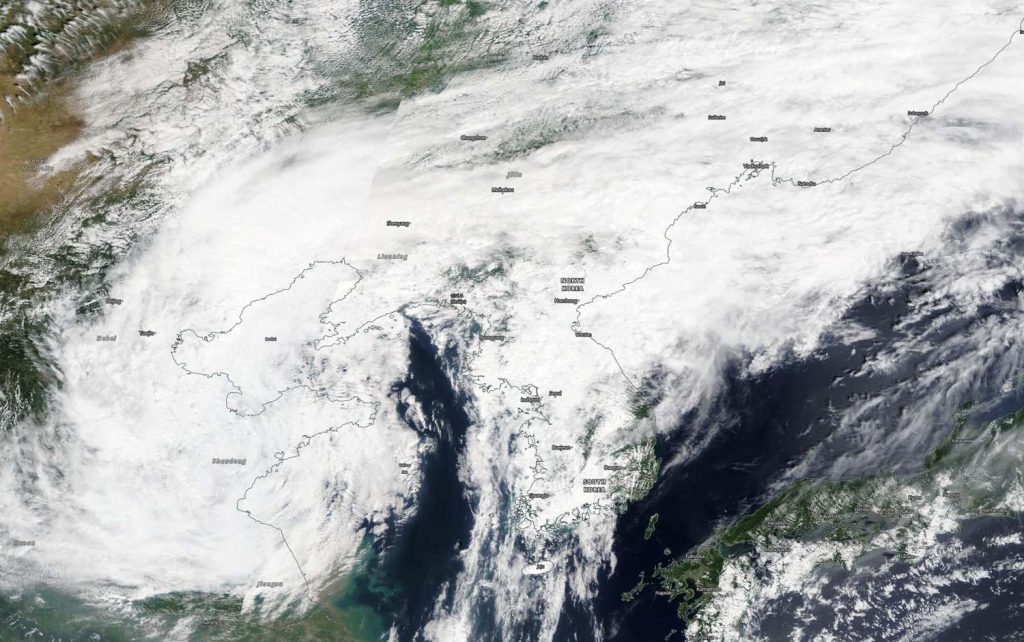
On Aug. 12, 2019, the MODIS instrument aboard NASA’s Terra satellite provided a visible image of former Typhoon Lekima in the Northwestern Pacific Ocean. Credit: NASA Worldview, Earth Observing System Data and Information System (EOSDIS)
On Aug. 12, 2019, the Moderate Resolution Imaging Spectroradiometer or MODIS instrument aboard NASA’s Terra satellite provided a visible image of Lekima’s remnant clouds. The remnants blanketed eastern China and the Korean Peninsula, also extending over part of the Yellow Sea.
Typhoon Lekima made landfall early on Aug. 10 in the Zhejiang province. At landfall, Lekima’s winds were gusting up to 185 kph (115 mph). Typhoon Lekima made another landfall in coastal regions of Huangdao district, Qingdao, Shandong around 8:50 p.m. local time on August 11. Lekima caused billions of dollars in damage, triggered travel delays and caused fatalities. Reuters reported that 44 people perished from Typhoon Lekima’s landfall in China.
On Aug. 12, China’s National Meteorological Center (NMC) released a blue warning for a typhoon at 6:00 a.m. local time. NMC noted, “Lekima [will] dwell in neighboring regions of northern Shandong Peninsula and move north by east direction with a dwindling intensity.”
The NMC forecast from August 12 to 13 noted that the areas including northern Shandong, northeastern Henan, eastern Tianjin, central-southern Liaoning, and eastern Jilin will be exposed to moderate and heavy rain. NMC’s forecast noted, “Heavy downpours (100-200 mm/3.9 to 7.8 inches) will pummel northeastern Hebei, and southwestern Liaoning.”
Aug. 09, 2019 – NASA Gives Typhoon Lekima a Twice-Over with the Aqua Satellite
NASA’s Aqua satellite provided infrared and visible views of Typhoon Lekima as it was approaching landfall in China. China has posted Typhoon and Heavy Rain Warnings for Lekima.
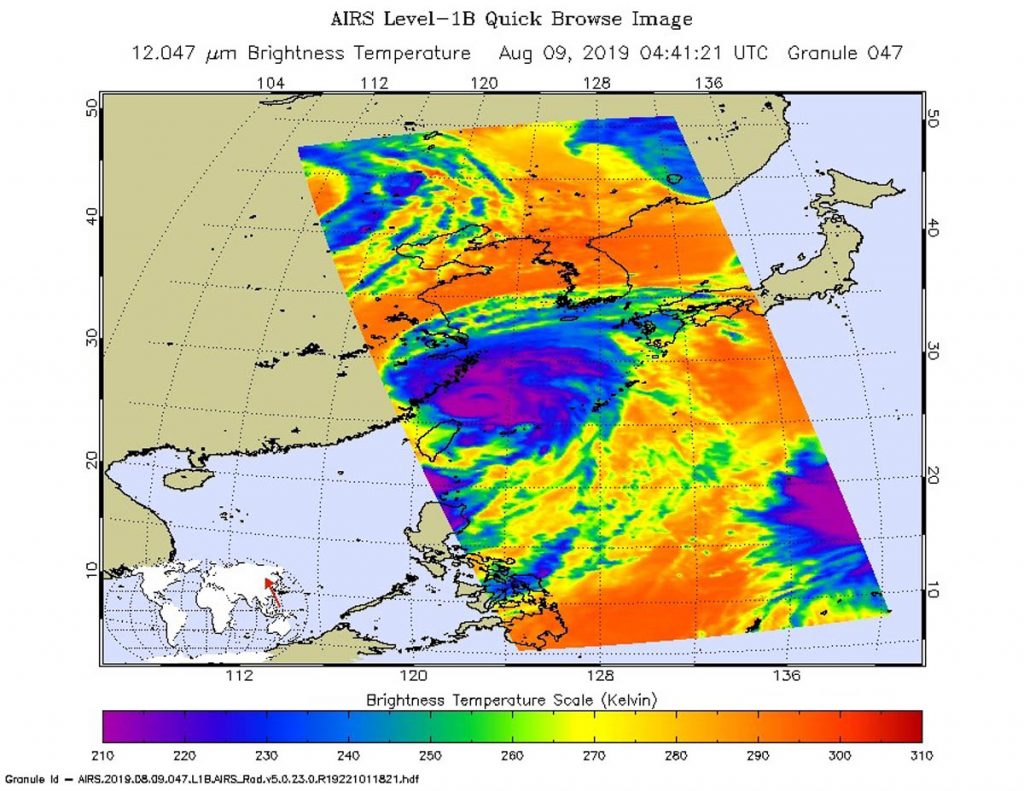
On Aug. 9 at 12:41 a.m. EDT (441 UTC) the AIRS instrument aboard NASA’s Aqua satellite analyzed Lekima’s cloud top temperatures in infrared light. AIRS found coldest cloud top temperatures (purple) of strongest thunderstorms were as cold as or colder than minus 63 degrees Fahrenheit (minus 53 degrees Celsius) in the thick band of thunderstorms around the eye and in bands north and southeast of the center. Credit: NASA JPL/Heidar Thrastarson
On Aug. 9 at 12:41 a.m. EDT (441 UTC) the Atmospheric Infrared Sounder or AIRS instrument aboard NASA’s Aqua satellite analyzed Lekima’s cloud top temperatures in infrared light. The stronger the storms, the higher they extend into the troposphere, and they have the colder cloud temperatures. AIRS found coldest cloud top temperatures as cold as or colder than minus 63 degrees Fahrenheit (minus 53 degrees Celsius) around the eye and in thick bands of thunderstorms wrapping into the center from the north and southeast. Storms with cloud tops that cold have been found to generate heavy rainfall.
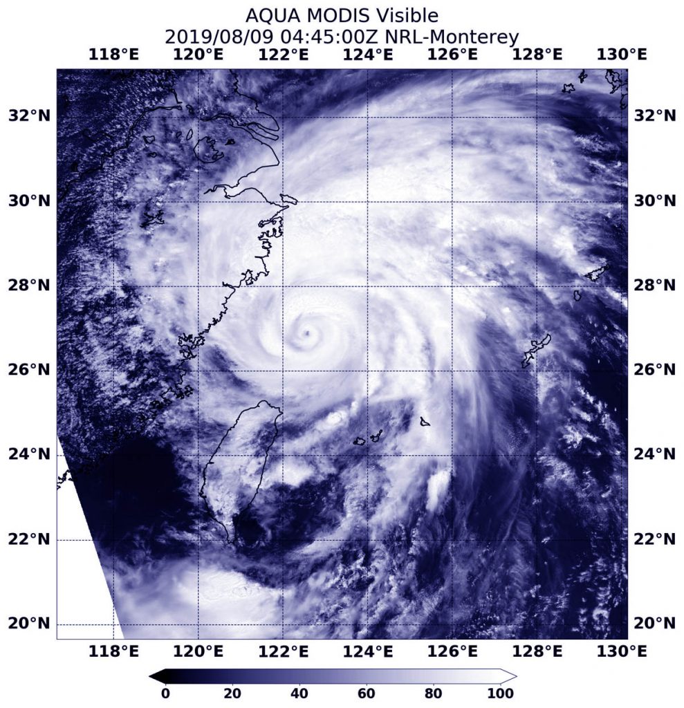
On Aug 9 at 12:45 a.m. EDT (0445 UTC), the Moderate Imaging Spectroradiometer or MODIS instrument that also flies aboard NASA’s Aqua satellite provided visible views of powerful Typhoon Lekima affecting China. The satellite showed a clear, small, rounded eye surrounded by a thick, powerful ring of thunderstorms and a large band of thunderstorms extending north of the center.
On Aug 9 at 12:45 a.m. EDT (0445 UTC), the MODIS instrument that flies aboard NASA’s Aqua revealed powerful Typhoon Lekima affecting China. The satellite showed a clear eye surrounded by a thick, powerful ring of thunderstorms and a large band of thunderstorms extending north of the center. Credit: NASA/NRL
At 11 a.m. EDT (1500 UTC) the center of Typhoon Lekima was located near latitude 27.8 degrees north latitude and longitude 121.8 degrees east. Lekima is moving toward the north-northeast. Maximum sustained winds are near 95 knots (109 mph/176 kph). Lekima is a Category 2 hurricane on the Saffir-Simpson Hurricane Wind Scale.
China’s National Meteorological Center (NMC) issued a Red Warning for the Typhoon at 10:00 a.m. local times on August 9 and an Orange Warning for rainstorm.
NMC said, “Typhoon Lekima is forecast to move northwest direction at the speed of 15-20 kph and moves towards coastal regions of Zhejiang and make landfall in coastal regions from Xiangshan to Cangnan of Zhejiang from the dawn to the daytime of August 10. From August 9 to 10, Bashi Channel, Taiwan Strait, coastal sea areas of Taiwan, East China Sea, Hangzhou Bay, Yangtze River Estuary, coastal regions of Zhejiang, Shanghai and southern Jiangsu, northern Taiwan Island, southern Huanghuai Sea, central-northern Fujian will be exposed to scale 7-9 gale.
Heavy rain to rainstorm will pummel Zhejiang, northern Fujian, eastern and southern Jiangsu, Shanghai, southeastern Anhui, and Taiwan Island. Heavy downpour will pound central-eastern Zhejiang, southern Shanghai, and Taiwan Island. Torrential downpour (250-320mm) will slam eastern Zhejiang and central Taiwan Island. (Aug. 9).”
The Orange Warning says, “It is predicted that from August 9 to 10, heavy rain to rainstorm will grip Zhejiang, northern Fujian, eastern and southern Jiangsu, Shanghai, southeastern Anhui, Taiwan Island, Beijing, central-southern Hebei, central Henan, southwestern and northern Chongqing, southern Sichuan, central-northern Yunnan, and eastern Heilongjiang. Heavy downpour will pound central-eastern Zhejiang, southern Shanghai, and Taiwan Island. Torrential downpour (250-320mm) will slam eastern Zhejiang and central Taiwan Island.”
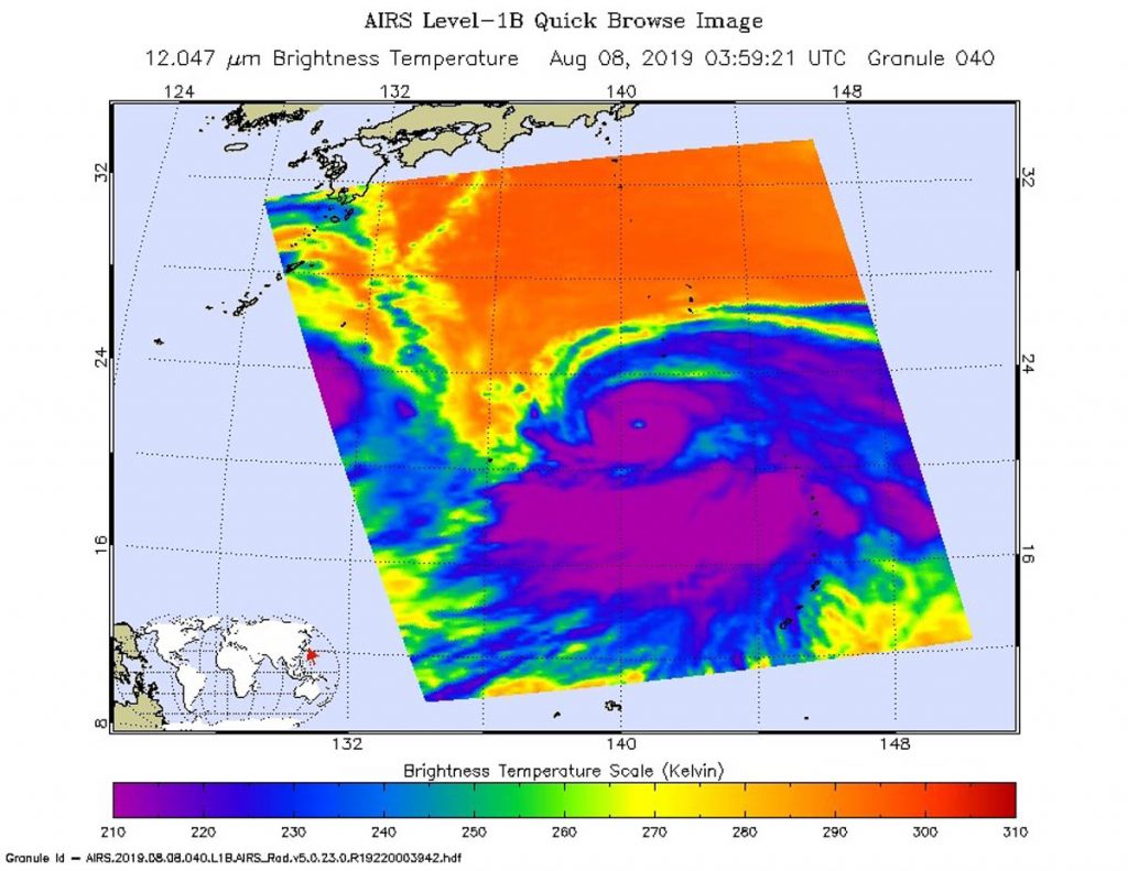
Aug. 09, 2019 – NASA’s Aqua Satellite Finds a Large Ragged Eye in Typhoon Krosa
Typhoon Krosa is a large storm moving through the Northwestern Pacific Ocean and infrared imagery from NASA’s Aqua satellite revealed that the large typhoon also has a large eye.
On Aug. 7 at 11 p.m. EDT (0359 UTC) the AIRS instrument aboard NASA’s Aqua satellite analyzed cloud top temperatures of Typhoon Krosa in infrared light. AIRS found coldest cloud top temperatures (purple) of strongest thunderstorms were as cold as or colder than minus 63 degrees Fahrenheit (minus 53 degrees Celsius). Krosa had a 40 nautical-mile-wide eye. Credit: NASA JPL/Heidar Thrastarson
Cloud top temperatures provide information to forecasters about where the strongest storms are located within a tropical cyclone. NASA’s Aqua satellite took Typhoon Krosa’s cloud top temperatures to get that information. NASA’s Aqua satellite analyzed the storm on Aug. 7 at 11 p.m. EDT (0359 UTC) using the Atmospheric Infrared Sounder or AIRS instrument. The stronger the storms, the higher they extend into the troposphere, and they have the colder cloud temperatures. AIRS found coldest cloud top temperatures as cold as or colder than minus 63 degrees Fahrenheit (minus 53 degrees Celsius) around the eye and in large bands south and east of the center. Cloud top temperatures that cold indicate strong storms that have the capability to create heavy rain.
Early on Aug. 9, the Joint Typhoon Warning Center noted that infrared data revealed that Krosa has an eye that is 40 nautical-miles wide.
At 5 a.m. EDT (0900 UTC) on Aug. 9, the center of Typhoon Krosa was located near latitude 22.0 degrees north and longitude 141.2 degrees east. That puts the center of Krosa about 168 nautical miles south of Iwo To island, Japan. Krosa was slowly crawling toward the east. Maximum sustained winds were near 85 knots (98 mph/157 kph).
The Joint Typhoon Warning Center expects that Krosa will turn northwest, and pass to the southwest of Iwo To island, Japan. It is then to continue tracking northwest and pass east of Minami Daito Jima, Kadena and Amami Oshima, on its way to the four main islands of Japan. Krosa is also expected to weaken over the next five days.
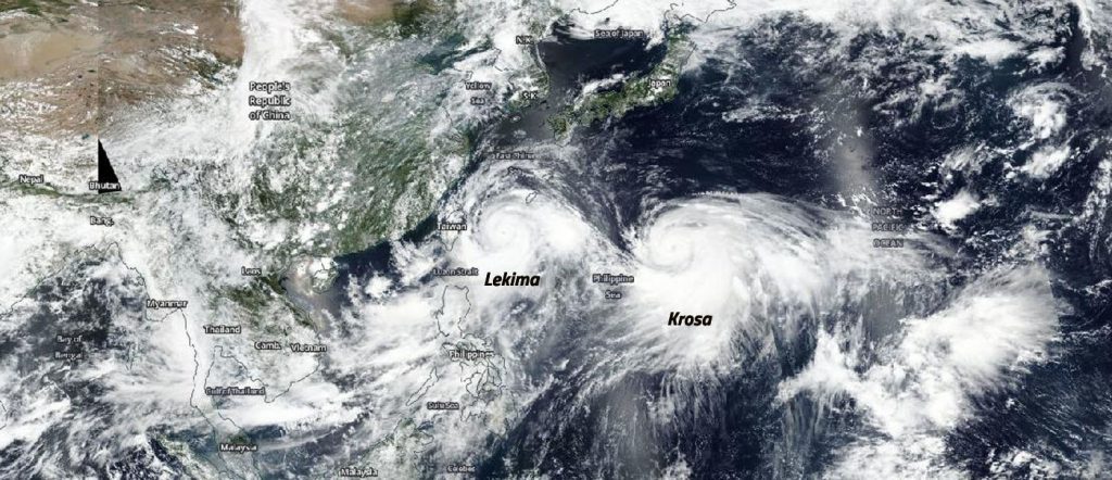
Aug. 08, 2019 – Typhoon Krosa Follows Leader Supertyphoon Lekima
NOAA-NASA’s Suomi NPP satellite captured this image using NASA’s Earth Observing System Data and Information System (EOSDIS) Worldview application on Aug. 08, 2019 and it shows Supertyphoon Lekima heading towards the coast of China as Typhoon Krosa brings up the rear moving slowly towards Japan.
NASA’s Earth Observing System Data and Information System (EOSDIS) Worldview application provides the capability to interactively browse over 700 global, full-resolution satellite imagery layers and then download the underlying data. Many of the available imagery layers are updated within three hours of observation, essentially showing the entire Earth as it looks “right now.” This NOAA NASA Suomi NPP satellite image was collected on August 08, 2019. Image Courtesy: NASA Worldview, Earth Observing System Data and Information System (EOSDIS).
Typhoon Krosa is currently located 167 nautical miles southwest of Iwo To, Japan. It is slowly tracking northeastward at one knot over the past six hours making it quasi-stationary as it intensified and maintained its 14 nautical mile eye.
Krosa’s winds are steady at approximately 100 knots (115 mph) which on the Saffir-Simpson hurricane scale would make this storm just over the Category 3 designation.
Like Lekima, Krosa is able to intensify due to low vertical wind shear and warm sea surface temperatures in the area of 30 degrees C (86 degrees F) both of which are favorable to typhoon development and intensification.
For the time being, Krosa will remain quasi-stationary and continue to intensify for the next 12 hours. Then the equatorial ridge nearby will steer the storm northeastward. The subtropical ridge will rebuild and steer north-northwestward toward Japan. Krosa will gradually weaken over the next five days, still maintaining typhoon strength throughout that period.
Aug. 08, 2019 – Lekima Becomes Supertyphoon, Heading Towards Eastern China
NASA’s Aqua satellite captured this infrared image of Supertyphoon Lekima as it tracked 214 nautical miles southwest of Okinawa, Japan. Tropical cyclone warning signal #1 is in force for the Luzon provinces of Batanes and Babuyan group of islands. The storm has tracked north-northwest at 10 knots over the past six hours.
NASA’s Aqua satellite was able to capture this infrared image of Supertyphoon Lekima on August 07, 2019 at 1:53pm (0453 UTC) with the AIRS instrument onboard. The dark purple shows the coldest cloud tops within the storm. Cloud top temperatures that cold indicate strong storms that have the capability to create heavy rain. Credit: NASA JPL/Heidar Thrastarson
Satellite imagery shows this system continues to rapidly intensify as evidenced by tightly compact central convection which includes an eight nautical mile-sized eye with a tight pinhole in the eye which is an indication of a strong storm.
The supertyphoon is currently producing winds in excess of 130 knots (149 mph). On the Saffir-Simpson hurricane scale that would be a Category 4 hurricane. With the low vertical wind shear this storm seems well defined and coupled with warm sea surface temperatures of 30 degrees C (86 degrees F) the conditions will most likely allow the storm to continue to intensify.
Supertyphoon Lekima is expected to reach the east coast of China near Taizhou within 48 hours and is expected to sustain the current intensity due to favorable conditions. Interaction with land, however, will begin to weaken the storm to 60 knots (69 mph) by 72 hours, shortly after it crosses over Shanghai. At that point the storm will turn north-northwest and rapidly weaken as it continues further inland.
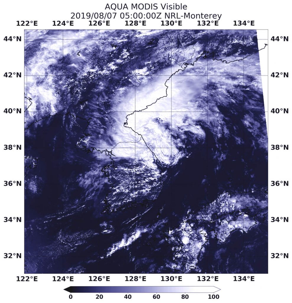
Aug. 07, 2019 – NASA Catches Transitioning Tropical Storm Francisco near Korean Peninsula
NASA’s Aqua satellite passed over the Sea of Japan and provided forecasters with a visible image of Tropical Storm Francisco as it was transitioning into an extra-tropical cyclone.
On Aug. 7, 2019 at 1:00 a.m. EDT (0500 UTC), the MODIS instrument aboard NASA’s Aqua satellite provided a visible image of Tropical Storm Francisco in the Sea of Japan, along the Korean Peninsula. Credit: NASA/NRL
Often, a tropical cyclone will transform into an extra-tropical cyclone as it recurves toward the poles (north or south, depending on the hemisphere the storm is located in). An extra-tropical cyclone is a storm system that primarily gets its energy from the horizontal temperature contrasts that exist in the atmosphere. Extra-tropical cyclones (also known as mid-latitude or baroclinic storms) are low pressure systems with associated cold fronts, warm fronts, and occluded fronts.
Tropical cyclones, in contrast, typically have little to no temperature differences across the storm at the surface and their winds are derived from the release of energy due to cloud/rain formation from the warm moist air of the tropics. Structurally, tropical cyclones have their strongest winds near the earth’s surface, while extra-tropical cyclones have their strongest winds near the tropopause – about 8 miles (12 km) up.
On Aug. 7, 2019 at 1:00 a.m. EDT (0500 UTC), the Moderate Resolution Imaging Spectroradiometer or MODIS instrument aboard NASA’s Aqua satellite provided a visible image of Francisco that showed it was still along the coast of the Korean Peninsula. It also appeared elongated from south to north.
At 5 a.m. EDT (0900 UTC), the Joint Typhoon Warning Center issued the final warning on Francisco. Maximum sustained winds dropped to near 35 knots (40 mph/65 kph). It was centered near 39.6 degrees north latitude and 129.3 degrees east longitude. That is 166 nautical miles northeast of Seoul, South Korea. Francisco was moving to the northeast.
The Joint Typhoon Warning Center noted that Francisco will traverse the Sea of Japan and move over Hokkaido while weakening.
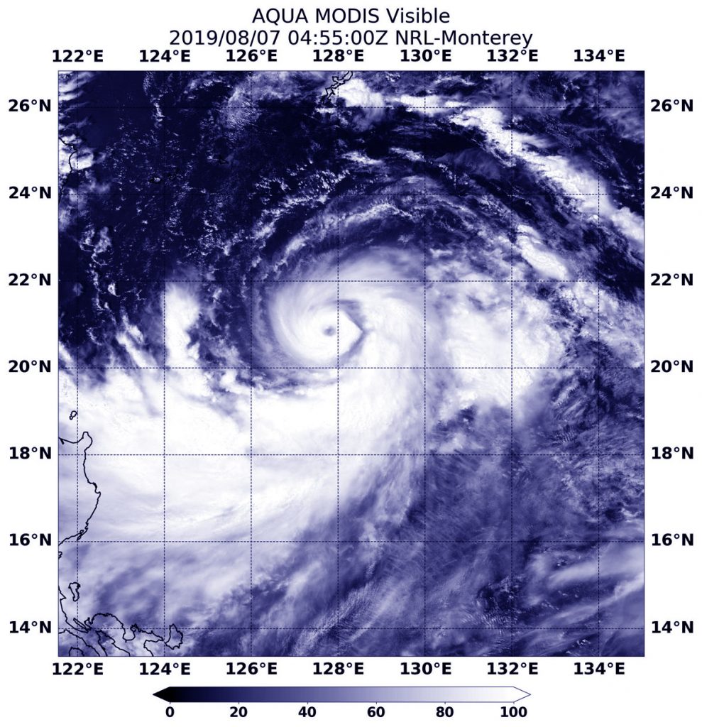
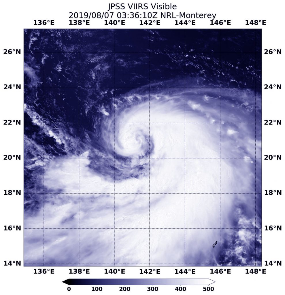
Aug. 07, 2019 – Philippines on Alert with Typhoon Lekima
Lekima is now a typhoon and has triggered warnings in the Philippines. NASA’s Aqua satellite passed over the Northwestern Pacific Ocean and provided a visible image of the storm that shows a clear eye.
On Aug. 7, 2019 at 12:55 a.m. EDT (0455 UTC), the MODIS instrument aboard NASA’s Aqua satellite provided a visible image of Typhoon Lekima in the Northwestern Pacific Ocean. Credit: NASA/NRL
On Aug. 7, the Philippines’ PAGASA service issued Tropical cyclone warning signal #1 for the Luzon provinces of Batanes and Babuyan group of islands.
On Aug. 7, 2019 at 12:55 a.m. EDT (0455 UTC), the Moderate Resolution Imaging Spectroradiometer or MODIS instrument aboard NASA’s Aqua satellite provided a visible image of Lekima that revealed a clear eye surrounded by a tight, circular band of powerful thunderstorms. Lekima also has a large band of thunderstorms that are feeding into the center from the south and east.
At 5 a.m. EDT (0900 UTC), Typhoon Lekima had maximum sustained winds near 85 knots (98 MPH/157 KPH). It was centered near 20.9 degrees north latitude and 127.7 degrees east longitude. That is 421 nautical miles south of Kadena Air Base, Okinawa island, Japan. Lekima was moving to the northwest and generating 25-foot high waves.
The Joint Typhoon Warning Center expects Lekima to continue moving northwest and strengthen to 125 knots (144 mph/232 kph), making it a Category 4 hurricane on the Saffir-Simpson hurricane wind scale. Lekima is expected to pass just north of northern Taiwan around August 9 and make landfall near Shanghai around August 12.
Aug. 07, 2019 – Tropical Storm Krosa Gets a Comma Shape
Tropical Storm Krosa continued on its journey northward in the Northwestern Pacific Ocean when NOAA’s NOAA-20 polar orbiting satellite passed overhead and captured a visible image of the strengthening storm in a classic tropical cyclone shape.
NOAA’s NOAA-20 polar orbiting satellite passed over the Northwestern Pacific Ocean and captured a visible image of Tropical Storm Krosa on Aug. 7, 2019. Credit: NASA/NRL/NOAA
The Visible Infrared Imaging Radiometer Suite (VIIRS) instrument aboard NOAA-20 provided a visible image of the storm. There’s also a VIIRS instrument aboard the NASA-NOAA Suomi NPP satellite that preceded NOAA-20.
The VIIRS image revealed Krosa had developed the signature “comma shape” of a strengthening storm. A large wide band of thunderstorms were feeding into the low-level center from the south and east of the center.
At 5 a.m. EDT (0900 UTC) on Aug. 7, Tropical Storm Krosa’s maximum sustained winds were near 60 knots (69 mph/111 kph) and strengthening. It was centered near 21.2 degrees north latitude and 141.3 degrees east longitude. That is about 31 nautical miles south of Iwo To island, Japan. Krosa was moving to the north-northwest.
The Joint Typhoon Warning Center said that Krosa will move northwest, and then later turn north while becoming a typhoon.
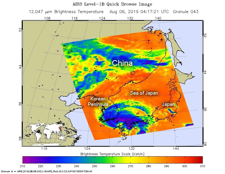
Aug. 06, 2019 – NASA Finds Tropical Storm Francisco in the Korea Strait
NASA’s Aqua satellite passed over the Korea Strait and found the center of Tropical Storm Francisco in the middle of it. The AIRS instrument aboard took the temperature of its cloud tops to estimate storm strength and found strong storms over two countries.
On Aug. 6, at 1217 a.m. EDT (0417 UTC). the AIRS instrument aboard NASA’s Aqua satellite analyzed cloud top temperatures of Tropical Storm Francisco in infrared light. AIRS found coldest cloud top temperatures (purple) of strongest thunderstorms were as cold as or colder than minus 63 degrees Fahrenheit (minus 53 degrees Celsius). Credit: NASA JPL/Heidar Thrastarson
The Korea Strait is a located between South Korea and Japan. It connects the East China Sea, the Yellow Sea and the Sea of Japan in the northwest Pacific Ocean.
NASA’s Aqua satellite passed over Francisco on Aug. 6, at 1217 a.m. EDT (0417 UTC). The Atmospheric Infrared Sounder or AIRS instrument aboard NASA’s Aqua satellite analyzed Francisco in infrared light and found cloud top temperatures of strongest thunderstorms as cold as or colder than minus 63 degrees Fahrenheit (minus 53 degrees Celsius) were wrapping around the low-level center from west to north to east. Cloud top temperatures that cold indicate strong storms that have the capability to create heavy rain. Those strong storms were affecting southern South Korea and southern Japan. The southern side of the storm appeared to have few storms.
At 11 a.m. EDT (1500 UTC), the center of Tropical Storm Francisco was located near latitude 36.2 degrees north and 129.4 degrees east longitude. Francisco’s center is about 33 nautical miles north-northeast of Busan, South Korea. It was moving to the northwest and had maximum sustained winds near 45 knots (52 mph/83 kph).
The Joint Typhoon Warning Center forecasts that Francisco will move north then turn northeast and curve east through the Sea of Japan and cross Hokkiado, the northernmost islands of Japan on Aug. 8.