21S – Southern Indian Ocean

Mar. 12, 2020 – NASA Finds Ex-Tropical Cyclone 21S Affecting Australia’s Pilbara Coast

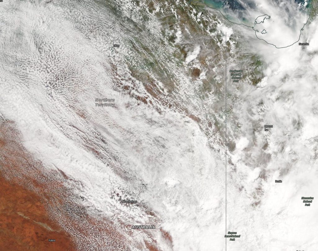
NASA’s Terra satellite passed over the Southern Indian Ocean and provided forecasters with a visible image of Ex-Tropical Cyclone 21S. Although no longer a tropical cyclone, the system has triggered warnings for heavy rainfall and winds.

Aqua image of 21S
On Mar. 12, 2020, the MODIS instrument that flies aboard NASA’s Terra satellite provided a visible image of Ex-Tropical Cyclone 21S, affecting Western Australia’s Pilbara coast. Credit: NASA Worldview

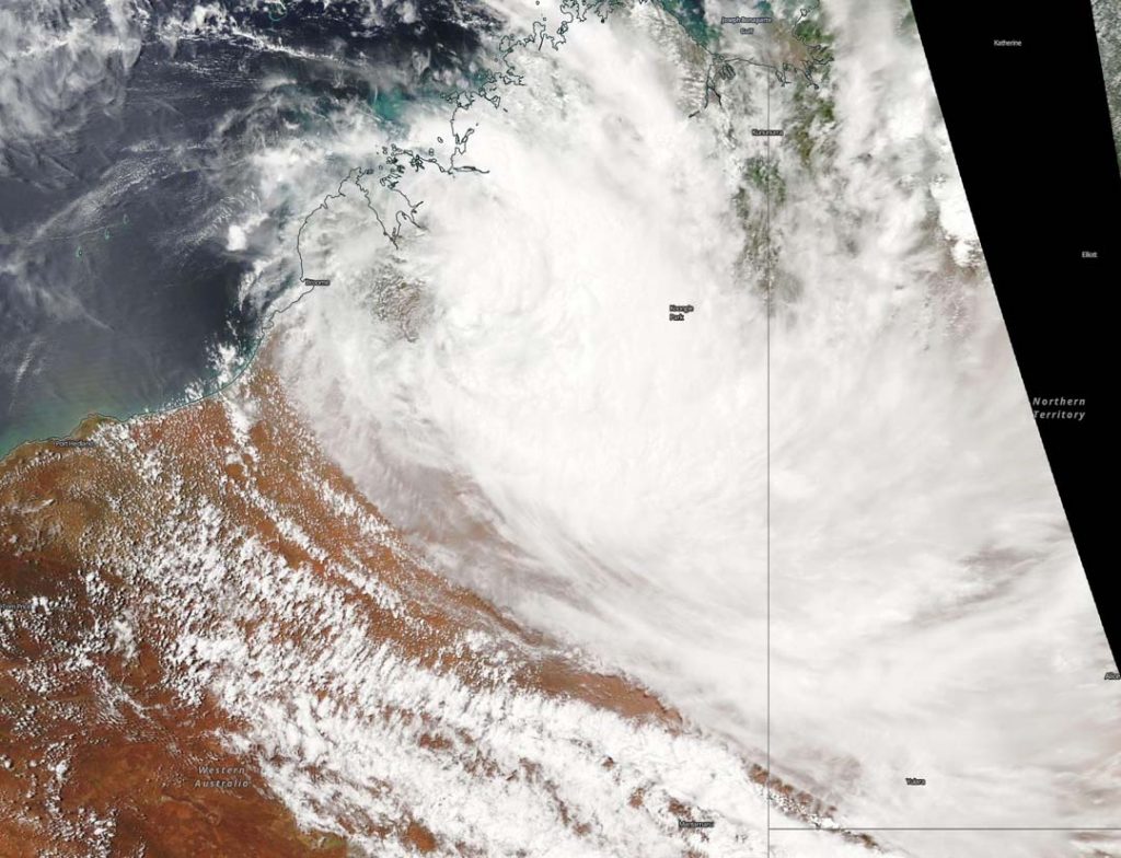
Tropical cyclone 21S was along the Pilbara coast. The Pilbara Coast is also known as the northwest coast of Western Australia.

The final warning from the Joint Typhoon Warning Center (JTWC) on 21S as a tropical system came on Mar. 11 at 5 p.m. EDT (2100 UTC). At the time, it had maximum sustained winds near 35 knots (64 kph/40 mph) and was moving to the southwest and toward the coast of Western Australia.

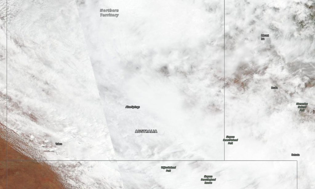
On March 12, the Moderate Resolution Imaging Spectroradiometer or MODIS instrument that flies aboard NASA’s Terra satellite provided a visible image of 21S that showed the storm affecting the states of Gascoyne and Pilbara. The image showed the low-level circulation center still offshore and the bulk of clouds and precipitation over Western Australia.

The Australian Bureau of Meteorology (ABM) issued warnings. ABM said, “Severe Weather events are forecast to affect Exmouth, Onslow, Barrow Island and Coral Bay. Along the northwest Pilbara coast between Mardie and Coral Bay, sustained gales are possible from late this evening until Friday morning. The weather system may also cause damaging wind gusts to 100 kilometers per hour that could result in damage to homes and property in or near thunderstorms. Heavy rainfall that may lead to flash flooding is possible with isolated falls of 50 to 100mm [`2 to 4 inches].”

At 4:00 p.m. AWST (4 a.m. EST) on Mar. 12, the ABM said ex-tropical cyclone 21S was located about 150 km (93 miles) north of Onslow, moving south southwest. ABM forecasters indicated the low-pressure area is expected to reach the coast later on Thursday or early Friday and may travel parallel to the Gascoyne coast. The tropical low-pressure area is not expected to intensify into a tropical cyclone but is likely to cause a period of heavy rainfall and squally winds.

NASA’s Terra satellite is one in a fleet of NASA satellites that provide data for hurricane research.

Tropical cyclones/hurricanes are the most powerful weather events on Earth. NASA’s expertise in space and scientific exploration contributes to essential services provided to the American people by other federal agencies, such as hurricane weather forecasting.

For updated forecasts from ABM, visit: http://www.bom.gov.au/

By Rob Gutro
NASA’s Goddard Space Flight Center

21S – Southern Indian Ocean

Mar. 11, 2020  – NASA-NOAA Satellite Catches Development of Tropical Storm 21S

NASA-NOAA’s Suomi NPP satellite passed over the Southern Indian Ocean and provided forecasters with a visible image of newly formed Tropical Storm 21S.

Suomi NPP image of 21S
NASA-NOAA’s Suomi NPP satellite passed over the Southern Indian Ocean and captured a visible image of newly formed Tropical Storm 21S off the coast of Western Australia. Credit: NASA Worldview, Earth Observing System Data and Information System (EOSDIS)

The Visible Infrared Imaging Radiometer Suite (VIIRS) instrument aboard Suomi NPP provided a visible image of Tropical Cyclone 21S that revealed strong thunderstorms circling the center of circulation. Strong storms were also in the southeastern quadrant of the storm which extended to the coast of Western Australia.

At 0900 UTC, (5 a.m. EDT) Tropical Cyclone 21S was located near latitude 16.4 degrees south and longitude 116.9 degrees east, about 253 nautical miles north-northwest of Port Hedland, Australia. 21S was moving to the south and had maximum sustained winds near 35 knots (40 mph/65 kph). The storm is not expected to strengthen much before it makes landfall in Western Australia.

The Joint Typhoon Warning Center (JTWC) expects 21S to move south-southeast and pass over Exmouth as a tropical storm. Exmouth is a town located on the tip of the North West Cape in Western Australia. JTWC forecasters expect that 21S will dissipate after two days.

Tropical cyclones/hurricanes are the most powerful weather events on Earth. NASA’s expertise in space and scientific exploration contributes to essential services provided to the American people by other federal agencies, such as hurricane weather forecasting.

For updated forecasts from the ABM, visit:  http://www.bom.gov.au

By Rob Gutro 
NASA Goddard Space Flight Center

Esther – South Indian Ocean

Mar. 04, 2020 – NASA Tracks Ex-Tropical Cyclone Esther Over Northern Territory

NASA’s Aqua satellite continues to provide forecasters with a visible image ex-tropical cyclone Esther’s remnant clouds and storms, now over the Barkly Region of Australia’s Northern Territory.

Aqua image of Esther
On Mar. 4, 2020, the MODIS instrument that flies aboard NASA’s Aqua satellite provided a visible image of Esther’s remnant clouds centered over the Barkly area of the Northern Territory. Credit: NASA Worldview

On March 4, the Moderate Resolution Imaging Spectroradiometer or MODIS instrument that flies aboard NASA’s Aqua satellite provided a visible image of Esther’s remnant clouds that showed the center over the Barkly region of the Northern Territory.

The Barkly Region is located in the west central part of the territory and the region’s main town is Tennant Creek. The region covers an area of 124,600 square miles (322,713 square km). Esther’s clouds stretched into Queensland.

On March 4, the Australian Bureau of Meteorology (ABM) issued a Flood Watch for the Tanami Desert, Central Desert, MacDonnell Ranges, Barkly, Georgina River and Simpson Desert.

At 10:38 a.m. ACST on Mar. 4 (8:08 p.m. EST on Mar. 3), ABM cautioned that widespread disruption to roads expected to continue in central parts for next few days.

Ex-tropical cyclone Esther is expected to move across the southern Barkly District and into southwestern Queensland later today, Mar. 4.

ABM noted, “During the past 48 hours widespread rainfall totals of 50 to 150 mm (2 to 6 inches) have been recorded in many parts of the southern Northern Territory with some totals even higher, mainly in the Tanami Desert and Barkly. Rainfall is expected to contract east during today with 20 – 50 mm (0.8 to 2 inch) daily totals expected into tomorrow in the upper Georgina River and Simpson Desert.”

Many areas have experienced localized flooding and areas of inundation during the past 48 hours.  ABM noted, “Many roads including major transport routes in the flood watch area are expected to continue to be affected and become or remain impassable with some communities and homesteads becoming isolated.”

NASA’s Aqua satellite is one in a fleet of NASA satellites that provide data for hurricane research.

Tropical cyclones/hurricanes are the most powerful weather events on Earth. NASA’s expertise in space and scientific exploration contributes to essential services provided to the American people by other federal agencies, such as hurricane weather forecasting.

For updated forecasts from ABM, visit: http://www.bom.gov.au/

By Rob Gutro
NASA’s Goddard Space Flight Center

Esther – South Indian Ocean

Mar. 03, 2020 – NASA Sees Ex-Tropical Cyclone Esther Move Back into Northern Territory

NASA-NOAA’s Suomi NPP satellite provided forecasters with a visible image ex-tropical cyclone Esther’s remnant clouds that have now moved over Australia’s Northern Territory. The remnants have generated a flood watch including in the Tanami and Central Deserts.

Suomi NPP image of Esther
NASA-NOAA’s Suomi NPP satellite provided an image on Mar. 3, 2020 that showed the remnant clouds and storms associated with ex-tropical cyclone Esther have blanketed the Northern Territory. Credit: NASA Worldview, Earth Observing System Data and Information System (EOSDIS)

Visible imagery from satellites help forecasters understand if a storm is organizing or weakening and the extent and movement of the storm. The Visible Infrared Imaging Radiometer Suite (VIIRS) instrument aboard Suomi NPP provided an image on Mar. 3 that showed the remnant clouds and storms associated with the ex-tropical cyclone have blanketed the Northern Territory. The center of ex-tropical cyclone Esther is located over the northern Tanami District.

On March 3, the Australian Bureau of Meteorology (ABM), Northern Territory issued a Flood Watch for the Tanami Desert, Central Desert, MacDonnell Ranges, Barkly, Georgina River and Simpson Desert. A flood warning was in effect for Sturt Creek District in Western Australia.

ABM noted widespread rainfall totals of 50 to 100 mm (~2 to 4 inches) have been recorded throughout the northern Tanami Desert. Some isolated areas received as much as 190 mm (7.5 inches).

ABM said, “Rainfall is expected to increase in the Central Desert and southeastern Tanami Desert from today with widespread falls of 70 to120 mm (2.8 to 4.7 inches) expected. Isolated falls of 180 mm (7 inches) could also be possible in places. Rainfall is also expected to increase in the MacDonnell Ranges and southern Barkly during today with 40 to 100 mm (1.6 to 4 inches) daily totals expected into tomorrow. Rainfall extends to the upper Georgina River and Simpson Desert during tomorrow with daily rainfall totals 20 to 80 mm (0.8 to 3.1 inches) expected in many areas.”

Esther is forecast to move southeast across the southern Barkly area to the Simpson District by Mar. 4.

Many roads including major transport routes in the flood watch area will continue to be affected and become or remain impassable with some communities and homesteads becoming isolated.

Tropical cyclones/hurricanes are the most powerful weather events on Earth. NASA’s expertise in space and scientific exploration contributes to essential services provided to the American people by other federal agencies, such as hurricane weather forecasting.

For updated forecasts from ABM, visit: http://www.bom.gov.au/ 

By Rob Gutro 
NASA’s Goddard Space Flight Center

Esther – South Indian Ocean

March 02, 2020 – NASA Finds Ex-Tropical Cyclone Esther Moving Back Inland

Ex-Tropical Cyclone Esther just won’t give up. The storm formed in the South Pacific Ocean, tracked across Australia’s Northern Territory and reached the Kimberley coast of Western Australia, and has now turned around. NASA’s Aqua satellite provided forecasters with a visible image of the storm turning back into Western Australia on March 2.

Aqua image of Esther
On Mar. 2, 2020, the MODIS instrument that flies aboard NASA’s Aqua satellite provided a visible image of Esther’s remnant clouds that showed the storm moved back inland and away from the coast. Credit: NASA Worldview

On March 2, the Moderate Resolution Imaging Spectroradiometer or MODIS instrument that flies aboard NASA’s Aqua satellite provided a visible image of Esther’s remnant clouds that showed the storm moved back inland and away from the coast.

The Australian Bureau of Meteorology (ABM) issued a Flood Watch for the Tanami Desert, Central Desert, MacDonnell Ranges, Barkly, Georgina River and Simpson Desert on March 2. A flood warning is current for Sturt Creek District in Western Australia.

At 10:48 a.m. ACST on Monday, March 2, the ABM forecast said, “Rainfall is expected to increase from today with widespread daily totals of 50 – 80 mm [2 to 3.1 inches] and isolated falls of 150 mm [5.9 inches] expected for the northern Tanami Desert. Rainfall into Tuesday is expected to increase with widespread falls of 70 – 120 mm [2.8 to 4.7 inches] expected in the Central Desert and southeastern Tanami Desert. Isolated falls of 180 mm [7.0 inches] could also be possible in places.

Rainfall is expected to increase in the MacDonnell Ranges and southern Barkly during Tuesday with 40 – 100 mm [1.6 to 3.9 inches] daily totals expected into Wednesday. Rainfall extends to the upper Georgina River and Simpson Desert during Wednesday with daily rainfall totals 20 – 80 mm [0.8 to 3.14 inches] expected in many areas.”

Many roads including major transportation routes in the flood watch area can expect to be affected on Mar. 2 and become impassable with some communities and homesteads becoming isolated.

Later today, ex-Tropical Cyclone Esther is expected to move into the northern Tanami District from the west as a strong arc of tropical low pressure.

NASA’s Aqua satellite is one in a fleet of NASA satellites that provide data for hurricane research.

Tropical cyclones/hurricanes are the most powerful weather events on Earth. NASA’s expertise in space and scientific exploration contributes to essential services provided to the American people by other federal agencies, such as hurricane weather forecasting.

For updated forecasts from ABM, visit: http://www.bom.gov.au/

By Rob Gutro
NASA’s Goddard Space Flight Center

Esther – South Indian Ocean

Feb. 28, 2020 – NASA Finds Ex-Esther Soaking Australia’s Kimberley Coast

Infrared imagery from NASA’s Terra satellite showed strong storms were soaking parts of Australia’s Kimberley coast on Feb. 28.

The Australia Bureau of Meteorology (ABM) issued a Severe Weather Warning for damaging winds and heavy rainfall for people in parts of Kimberley district. Locations which may be affected include Kununurra, Wyndham, Lake Argyle, Warmun, Mitchell Plateau, Troughton Island and Mount Burnett. ABM cautioned that widespread daily rainfall totals of 50 to 150mm (~2 to 6 inches) with isolated falls 250 to 300mm (~10 to 12 inches) are possible. Ex-Tropical Cyclone Esther may cause damaging winds, averaging 35 to 45 kph (22 to 28 mph) with wind gusts potentially reaching 90 kph (56 mph).

grid with land outlines, half painted with red and green hurricane data
On Feb. 28 at 12:55 a.m. EST (0555 UTC) the MODIS instrument that flies aboard NASA’s Terra satellite found coldest cloud top temperatures (yellow) in two areas around Esther’s center of circulation. They were as cold as or colder than minus 80 degrees Fahrenheit (minus 62.2 Celsius). One area of strong storms were off the coast and over the Southern Indian Ocean. That area stretched from Kalumburu in the northeast, southwest to off the coast of Prince Regent National Park. The second area of strongest storms were over land, from Prince Regent National Park stretching east to Drysdale River National Park. Credit: NASA/NRL

A Flood Watch has also been issued for parts of the Kimberley District. For further details please refer to http://www.bom.gov.au/wa/warnings/.

Tropical cyclones are made of up hundreds of thunderstorms, and infrared data can show where the strongest storms are located. They can do that because infrared data provides temperature information, and the strongest thunderstorms that reach highest into the atmosphere have the coldest cloud top temperatures. Convection is rising air that condenses and forms the thunderstorms that make up a tropical cyclone. When it is strong, it pushes clouds higher into the troposphere (the layer of atmosphere closest to Earth’s surface). The higher you go in the troposphere, the colder the air temperature gets, so colder cloud tops indicate stronger, higher storm cloud tops.

On Feb. 28 at 12:55 a.m. EST (0555 UTC) the Moderate Imaging Spectroradiometer or MODIS instrument that flies aboard NASA’s Terra satellite found coldest cloud top temperatures in two areas around Esther’s center of circulation. They were as cold as or colder than minus 80 degrees Fahrenheit (minus 62.2 Celsius). NASA research has found that cloud top temperatures that cold indicate strong storms with the potential to generate heavy rainfall.

One area of strong storms were off the coast and over the Southern Indian Ocean. That area stretched from Kalumburu in the northeast, southwest to off the coast of Prince Regent National Park. The second area of strongest storms were over land, from Prince Regent National Park stretching east to Drysdale River National Park.

At 3 a.m. EST (4 p.m. AWST) on Feb. 28, the center of Ex-Tropical Cyclone Esther was located about 78 miles (125 km) west of Wyndham. Esther was moving towards the west at about 9 miles per hour (15 kph).

Ex-Tropical Cyclone Esther is expected to continue moving in a westerly direction, through the northern Kimberley during Friday, Feb. 28.

ABM noted that the Severe Weather Warning is likely to extend further to the west and south later on Saturday, Feb. 29 as the Esther moves in a general southwesterly direction through the Kimberley.

Tropical cyclones are the most powerful weather event on Earth. NASA researches these storms to determine how they rapidly intensify, develop and behave. NASA’s expertise in space and scientific exploration contributes to essential services provided to the American people by other federal agencies, such as hurricane weather forecasting.

Rob Gutro
NASA’s Goddard Space Flight Center, Greenbelt, Md.


Ferdinand – Southern Indian Ocean

Feb. 28, 2020 – NASA Finds Dry Air Sapping Tropical Cyclone Ferdinand’s Strength  

When NASA’s Aqua satellite passed over the Southern Indian Ocean on Feb. 28, it obtained water vapor data on Tropical Cyclone Ferdinand. The water vapor data indicated the storm was being eaten away by dry air.

NASA’s Aqua satellite passed over Tropical Cyclone Ferdinand on Feb. 28 at 1:55 a.m. EST (0555 UTC) and the Moderate Resolution Imaging Spectroradiometer or MODIS instrument gathered water vapor content and temperature information. The MODIS image showed highest concentrations of water vapor and coldest cloud top temperatures had diminished in the last 24 hours, forming a compact area of strong storms around center of circulation. Microwave imagery even suggested an eye in the center.

red/black blob and arc suggest a hurricane on a field of bluegreen data
On Feb. 28 at 1:55 a.m. EST (0555 UTC), NASA’s Aqua satellite passed over Tropical Cyclone Ferdinand, located in the Southern Indian Ocean and off Australia’s Pilbara coast. Aqua found highest concentrations of water vapor (brown) and coldest cloud top temperatures were shrinking around the center. Credits: NASA/NRL

The MODIS water vapor data revealed that small area of strong storms had cloud top temperatures as cold as or colder than minus 70 degrees Fahrenheit (minus 56.6 degrees Celsius). Storms with cloud top temperatures that cold have the capability to produce heavy rainfall. There was also a small fragmented band of thunderstorms northeast of the center. The imagery showed dry air moving in from west of the center quelled thunderstorm development and precipitation in the western quadrant of the storm.

Water vapor analysis of tropical cyclones tells forecasters how much potential a storm has to develop. Water vapor releases latent heat as it condenses into liquid. That liquid becomes clouds and thunderstorms that make up a tropical cyclone. Temperature is important when trying to understand how strong storms can be. The higher the cloud tops, the colder and the stronger the storms.

The Australian Bureau of Meteorology (ABM) said on Feb. 28, “Ferdinand is a small tropical cyclone located well north of the Western Australia coast.”

On Friday, February 28 at 8:00 p.m. AWST, ABM said Ferdinand had sustained winds near the center of 95 kilometers (51 knots/59 miles) per hour. Ferdinand is located near 16.2 degrees south latitude and 112.8 degrees east longitude, about 650 kilometers (404 miles) north-northwest of Onslow and 760 kilometers (472 miles) northwest of Port Hedland.

Forecasters at the ABM expect Ferdinand to move further northwest and weaken below tropical cyclone strength over the next 24 hours. The Joint Typhoon Warning Center said Ferdinand is forecast to weaken steadily due to dry air continuing to funnel into the storm, and vertical wind shear persisting. Ferdinand is forecast to dissipate by Sunday, March 1, but could dissipate earlier.

NASA’s Aqua satellite is one in a fleet of NASA satellites that provide data for hurricane research.

Tropical cyclones are the most powerful weather event on Earth. NASA’s expertise in space and scientific exploration contributes to essential services provided to the American people by other federal agencies, such as hurricane weather forecasting.

Rob Gutro
NASA’s Goddard Space Flight Center, Greenbelt, Md.

Ferdinand – Southern Indian Ocean

Feb. 27, 2020 – NASA Finds Dry Air Affecting Tropical Cyclone Ferdinand

NASA’s Terra satellite revealed the bulk of Ferdinand’s strong storms were in its eastern quadrant. Dry air is moving into the storm, causing it to weaken.

On Feb. 27, the Moderate Imaging Spectroradiometer or MODIS instrument that flies aboard NASA’s Terra satellite provided a visible image of Ferdinand, located in the Southern Indian Ocean, and far off the Pilbara coast of Western Australia. Satellite imagery depicts a rapidly weakening system. A satellite image revealed a well-defined low-level circulation center with limited deep convection over the eastern quadrant of the storm.

On Feb. 27, 2020, the MODIS instrument that flies aboard NASA’s Terra satellite provided a visible image of Tropical Cyclone Ferdinand far off the Pilbara coast of Western Australia. Credit: NASA Worldview

Animated total precipitable water imagery and recent visible imagery indicate a significant amount of dry air is moving into the storm, which is the main factor in the weakening trend. Dry air inhibits development of thunderstorms, which make up tropical cyclones.

At 10 a.m. EST (1500 UTC), Ferdinand had maximum sustained winds near 55 knots (63 mph/102 kph) and continued to weaken. It was centered near 16.9 degrees south latitude and 114.0 degrees east longitude, about 324 nautical miles north of Learmonth, Australia. Ferdinand was moving to the southwest.

The Joint Typhoon Warning Center forecasts Ferdinand to continue weaken and move on a westerly track, further away from land.

NASA’s Terra satellite is one in a fleet of NASA satellites that provide data for hurricane research.

Tropical cyclones are the most powerful weather event on Earth. NASA’s expertise in space and scientific exploration contributes to essential services provided to the American people by other federal agencies, such as hurricane weather forecasting.

Rob Gutro
NASA’s Goddard Space Flight Center, Greenbelt, Md.

Esther – Southern Pacific Ocean

Feb. 27, 2020 – NASA Follows Ex-Tropical Storm Esther’s Slow Trek

NASA’s Aqua satellite has been tracking the life of now Ex-Tropical Cyclone Esther since it developed in the Gulf of Carpentaria and made landfall on the eastern side of the Northern Territory on Feb. 24. Aqua continues to provide forecasters with imagery of the storm’s slow westerly movement through the Northern Territory.

On Feb. 27, the Moderate Imaging Spectroradiometer or MODIS instrument that flies aboard NASA’s Aqua satellite provided a visible image of Esther that showed the storm’s center of circulation was nearing the Joseph Bonaparte Gulf and the border between the Northern Territory and Western Australia (NT/WA). Ex-Tropical Cyclone Esther’s strongest storms were in the western part of the Northern Territory where it has triggered a flood watch. However, Esther is a large system, so its clouds extended across the entire territory.

On Feb. 27, 2020, the MODIS instrument that flies aboard NASA’s Aqua satellite provided a visible image of Ex-Tropical Storm Esther tracking slowly through Australia’s Northern Territory. Credit: NASA Worldview

The Australian Bureau of Meteorology (ABM)  reported at 7 a.m. EST/9:30 p.m. ACST, Ex-Tropical Cyclone Esther was located over land about 68 miles/110 km west-northwest of Timber Creek and 70 km/43 miles east of the NT/WA border, moving west at about kph/6.2 mph.

ABM said, “The system is expected to continue moving west into the eastern Kimberley region on Friday [Feb. 28] morning. The low is expected to strengthen overnight as it draws in moisture from the Timor Sea.”

ABM cautions heavy rainfall may cause flash flooding over the Gregory and Daly Districts tonight [Feb.27] and Friday morning. Widespread rainfall of 50 to 150 mm/ ~2 to 6 inches with isolated amounts up to 200 mm/7.8 inches are expected, with the heaviest rainfall likely to develop tonight and tomorrow morning. “Damaging winds averaging 50 to 60 kph/31 to 37 mph with peak gusts of around 90 kph/56 mph are possible with thunderstorms in the western Gregory and southwest Daly District.

Areas of heavy rainfall and damaging winds are expected to contract westwards during Friday.”

A Flood Watch is in effect for the Carpentaria, Bonaparte and North West Coastal Rivers. Locations which may be affected include Darwin, Palmerston, Wadeye, Nauiyu, Kalkarindji and Pine Creek.

NASA’s Aqua satellite is one in a fleet of NASA satellites that provide data for hurricane research.

Tropical cyclones are the most powerful weather event on Earth. NASA’s expertise in space and scientific exploration contributes to essential services provided to the American people by other federal agencies, such as hurricane weather forecasting.

For updated forecasts from ABM, visit: http://www.bom.gov.au/nt/warnings/

Rob Gutro
NASA’s Goddard Space Flight Center, Greenbelt, Md.

Esther – Southern Pacific Ocean

Feb. 26, 2020 – NASA Tracking Ex-Tropical Cyclone Esther’s March

Ex-Tropical Cyclone Esther continues to march west through Australia’s Northern Territory and NASA’s Aqua satellite provided forecasters with a visible image of the low-pressure system.

On Feb. 26, the Moderate Imaging Spectroradiometer or MODIS instrument that flies aboard NASA’s Aqua satellite provided a visible image of Esther’s clouds. The image showed that as the system weakened it has expanded over the Northern Territory. Clouds extend from the Gulf of Carpentaria in the east, almost reaching the western border shared with Western Australia.

On Feb. 26, 2020, the MODIS instrument that flies aboard NASA’s Aqua satellite provided a visible image of Ex-tropical cyclone Esther’s clouds moving through the Northern Territory of Australia. Credit: NASA Worldview

The Australian Bureau of Meteorology (ABM) noted 9:30 p.m. CST (7 a.m. EST) on Feb. 26, Ex-Tropical Cyclone Esther was located about 100 kilometers (62 miles) east northeast of Victoria River Downs, moving west northwest at about 15 kph (9 mph). The system is expected to continue moving west, moving across the Gregory District during Thursday as a deep tropical low-pressure area.

ABM forecasts heavy rainfall, which may lead to flash flooding to develop over the Gregory and southwest Daly Districts during Thursday. “The risk of widespread heavy rainfall has eased in the Carpentaria and Barkly Districts but isolated thunderstorms are expected to continue.” In addition, ABM noted “Damaging winds are possible with thunderstorms in the western Gregory and southwest Daly District. Locations which may be affected include Wadeye, Kalkarindji, Timber Creek, Daguragu, Palumpa and Peppimenarti.”

The low-pressure area is expected to strengthen further from Thursday afternoon as it draws in moisture from the Timor Sea.

NASA’s Aqua satellite is one in a fleet of NASA satellites that provide data for hurricane research.

Tropical cyclones are the most powerful weather event on Earth. NASA’s expertise in space and scientific exploration contributes to essential services provided to the American people by other federal agencies, such as hurricane weather forecasting.

For updated forecasts from ABM, visit:  http://www.bom.gov.au/nt/warnings/

Rob Gutro
NASA’s Goddard Space Flight Center, Greenbelt, Md.