Gelena (Southern Indian Ocean)

Feb. 15, 2019 – NASA Catches Tropical Cyclone Gelena’s Post-Tropical Transition

Tropical cyclones can become post-tropical before they dissipate, meaning they can become sub-tropical, extra-tropical or a remnant low pressure area.  As Tropical Cyclone Gelena transitioned into a subtropical storm, NASA’s Aqua satellite provided a visible image of the storm.
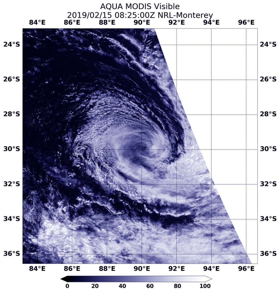
Aqua image of Gelena
On Feb 15 at 10 p.m. EDT (Feb. 16 at 0300 UTC), the MODIS instrument aboard NASA’s Aqua satellite provided a visible image of Gelena that showed the storm had transitioned into a post-tropical cyclone. Credit: NASA/NRL

On Feb 15 at 10 p.m. EDT (Feb. 16 at 0300 UTC), the Joint Typhoon Warning Center or JTWC noted that Gelena had already become subtropical. JTWC issued their final warning on Gelena. At that time, the storm had maximum sustained winds near 40 knots (46 mph/74 kph). It was centered near 29.8 degrees south latitude and 89.3 degrees east longitude. That’s 1,426 nautical miles east-southeast of Learmonth, Australia. Gelena was moving east-southeast.

What is a Post-tropical Storm? 

A Post-Tropical Storm is a generic term for a former tropical cyclone that no longer possesses sufficient tropical characteristics to be considered a tropical cyclone. Former tropical cyclones that have become fully extratropical, subtropical, or remnant lows, are three classes of post-tropical cyclones. In any case, they no longer possesses sufficient tropical characteristics to be considered a tropical cyclone. However, post-tropical cyclones can continue carrying heavy rains and high winds.

What is a Sub-tropical Storm?

 According to the National Oceanic and Atmospheric Administration, a sub-tropical storm is a low-pressure system that is not associated with a frontal system and has characteristics of both tropical and extratropical cyclones. Like tropical cyclones, they are non-frontal that originate over tropical or subtropical waters, and have a closed surface wind circulation about a well-defined center.

Unlike tropical cyclones, subtropical cyclones derive a significant proportion of their energy from baroclinic sources (atmospheric pressure), and are generally cold-core in the upper troposphere, often being associated with an upper-level low pressure area or an elongated area or trough of low pressure.

In comparison to tropical cyclones, these systems generally have a radius of maximum winds occurring relatively far from the center (usually greater than 60 nautical miles), and are generally less symmetric.

What is an Extra-tropical Storm?

Often, a tropical cyclone will transform into an extra-tropical cyclone as it recurves toward the poles (north or south, depending on the hemisphere the storm is located in). An extra-tropical cyclone is a storm system that primarily gets its energy from the horizontal temperature contrasts that exist in the atmosphere.

Tropical cyclones have their strongest winds near the earth’s surface, while extra-tropical cyclones have their strongest winds near the tropopause – about 8 miles (12 km) up. Tropical cyclones, in contrast, typically have little to no temperature differences across the storm at the surface and their winds are derived from the release of energy due to cloud/rain formation from the warm moist air of the tropics.

Visible NASA Imagery Shows the Transition

Visible imagery from NASA’s Aqua satellite revealed Gelena’s subtropical transition.

At 3:25 a.m. EDT (0825 UTC) on Feb. 15, 2019, the Moderate Resolution Imaging Spectroradiometer or MODIS instrument aboard NASA’s Aqua satellite provided a visible image of subtropical storm Gelena in the Southern Indian Ocean.  The MODIS image showed Gelena had a closed surface wind circulation about a well-defined center, but the storm has become asymmetric (as subtropical storms do).

The Joint Typhoon Warning Center noted “animated multispectral satellite imagery shows cloud tops continuing to warm and convective structure continuing to unravel. [Another satellite] image showed remnant convective bands [of thunderstorms] sheared (pushed by winds) to the south and wrapping into an elongated partially exposed low level circulation center.”

Gelena is expected to continue moving through the Southern Indian Ocean over the next day until it dissipates.

By Rob Gutro
NASA’s Goddard Space Flight Center

Gelena (Southern Indian Ocean)

Feb. 14, 2019 – NASA’s Aqua Satellite Finds Winds Battering Tropical Cyclone Gelena

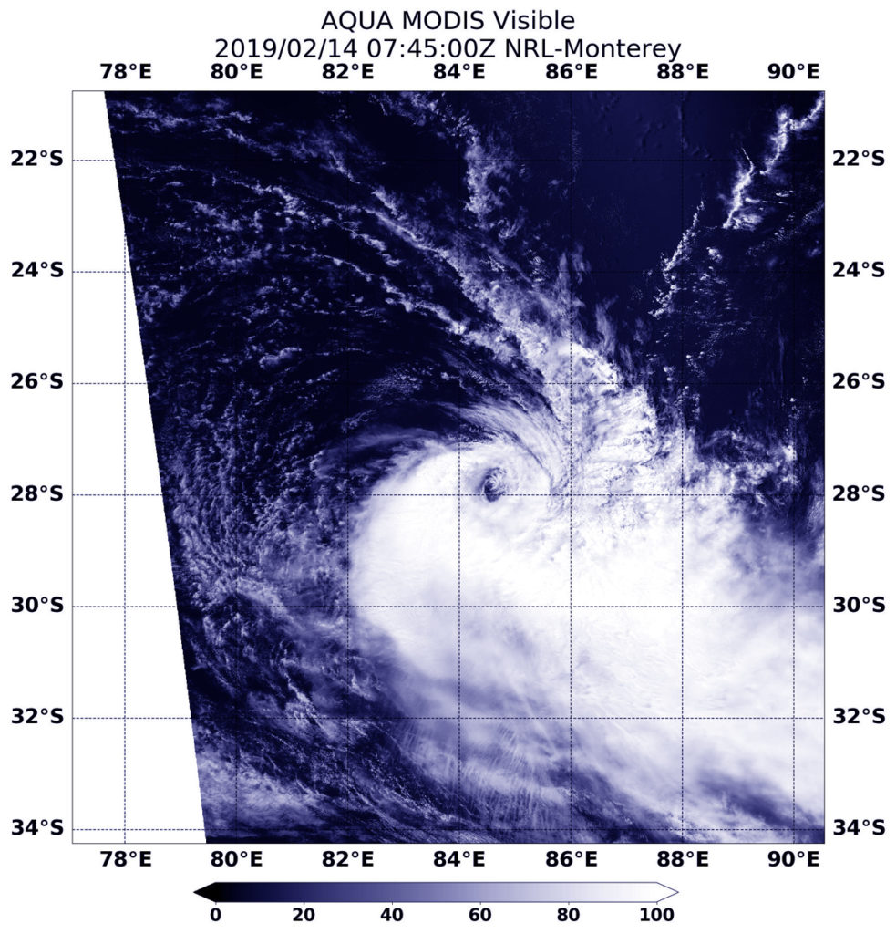
Tropical Cyclone Gelena is being battered by outside winds, and that’s weakening the storm. Visible imagery from NASA’s Aqua satellite revealed the bulk of clouds in Tropical Cyclone Gelena were pushed away from the center.

Aqua image of Gelena
On Feb. 14, 2019 at 2:45 a.m. EDT (0745 UTC) the MODIS instrument aboard NASA’s Aqua satellite captured a visible light image of Tropical Cyclone Gelena being battered by wind shear in the Southern Indian Ocean. Credit: NASA/NRL

On Feb. 14, 2019 at 2:45 a.m. EDT (0745 UTC) the Moderate Resolution Imaging Spectroradiometer or MODIS instrument aboard NASA’s Aqua satellite captured a visible image of Tropical Cyclone Gelena in the Southern Indian Ocean. The image showed Gelena’s clear low level center of circulation, and the bulk of the tropical cyclone’s clouds pushed south of the center. That’s because of strong northerly wind shear.

In general, wind shear is a measure of how the speed and direction of winds change with altitude. Wind shear can tear a tropical cyclone apart or weaken it.

On Feb 14 at 10 a.m. EDT (1500 UTC), Gelena’s maximum sustained winds were near 40 knots (46 mph/74 kph). It was centered near 28.6 degrees south latitude and 86.6 east longitude. Tropical Cyclone Gelena is approximately 1,474 nautical miles south-southeast of Diego Garcia, and has tracked east-southeastward.

The Joint Typhoon Warning Center expects Gelena to dissipate in 24 hours as it continues to face strong vertical wind shear and moves into increasingly cooler sea surface temperatures.

By Rob Gutro
NASA’s Goddard Space Flight Center

Gelena (Southern Indian Ocean)

Feb. 13, 2019 – NASA Finds Tropical Cyclone Gelena in the Middle of the Southern Indian Ocean

Visible imagery from NASA’s Terra satellite showed a weaker Tropical Storm Gelena far from land areas, and in the middle of the Southern Indian Ocean.

Terra image of Gelena
On Feb. 13, 2019 the MODIS instrument aboard NASA’s Terra satellite provided a visible image of Tropical Cyclone Gelena in the Southern Indian Ocean that showed bands of thunderstorms spiraling into the center. Credit: NASA Worldview, EARTH Observing System Data and Information System (EOSDIS).

On Feb. 13, the Moderate Resolution Imaging Spectroradiometer or MODIS instrument aboard NASA’s Terra satellite provided a visible image of Gelena. The image showed bands of thunderstorms spiraling into a cloud-filled, but defined low level circulation with the bulk of its associated convection and clouds pushed eastward from westerly winds.

At 10 a.m. EDT (1500 UTC) on Feb. 13, the Joint Typhoon Warning Center or JTWC noted that Oma had maximum sustained winds near 55 knots (63 mph/102 kph). It was centered near 26.0 degrees north latitude and 79.2 degrees east longitude. That’s 1,193 nautical miles east-southeast of Port Louis, Mauritius. Omi was moving east-southeast.

JTWC has forecast Gelena to continue moving southeastward and weakening to dissipation in two days.

By  Rob Gutro
NASA’s Goddard Space Flight Center

Gelena (Southern Indian Ocean)

Feb. 12, 2019 – NASA-NOAA Satellite Finds Tropical Cyclone Gelena Sheared

Wind shear can push tropical cyclones apart and satellite imagery from NASA-NOAA’s Suomi NPP satellite revealed that is what is happening to Tropical Cyclone Gelena in the Southern Indian Ocean.

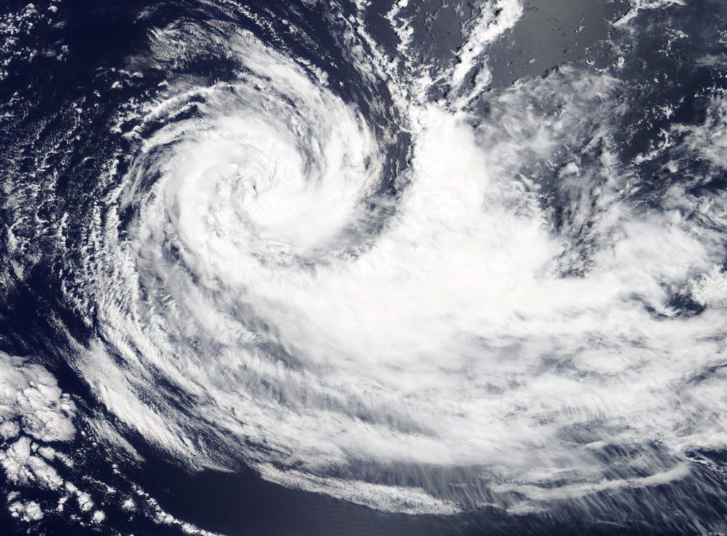
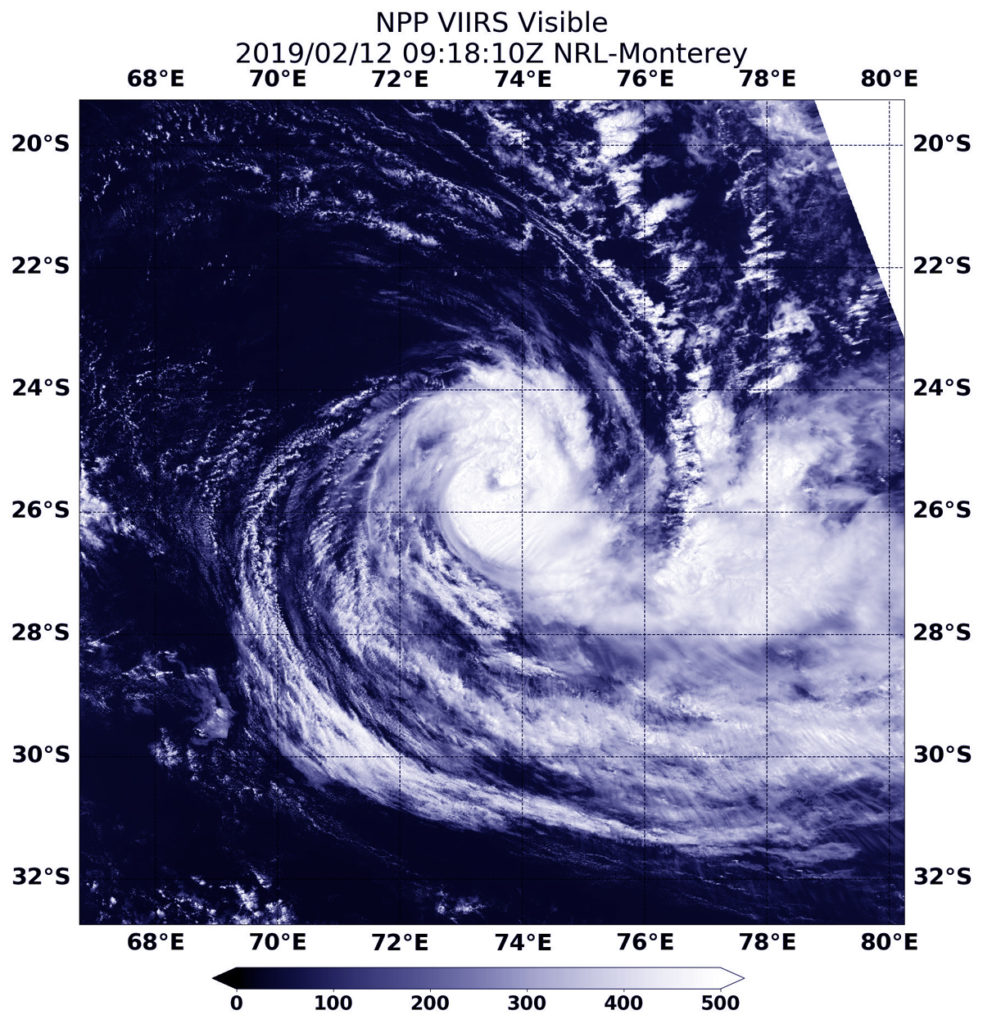
Suomi NPP image of Gelena
On Feb. 12 at 4:18 a.m. EDT (0918 UTC) the VIIRS instrument aboard NASA-NOAA’s Suomi NPP satellite captured a visible image of Tropical Cyclone Gelena moving through the Southern Indian Ocean. Credit: NASA/NOAA/NRL

In general, wind shear is a measure of how the speed and direction of winds change with altitude. Winds at different levels of the atmosphere pushed against the cylindrical circulation center and skewed it, weakening the rotation.

On Feb. 12 at 4:18 a.m. EDT (0918 UTC) the Visible Infrared Imaging Radiometer Suite (VIIRS) instrument aboard NASA-NOAA’s Suomi NPP satellite captured a visible image of Tropical Cyclone Gelena moving through the Southern Indian Ocean. The Joint Typhoon Warning Center noted that: “Animated multispectral satellite imagery shows a system with a mostly exposed low level circulation and its associated convection sheared eastward.”  The clouds are being pushed eastward by strong westerly winds.

On Feb. 12 at 10 a.m. EDT (1500 UTC) Gelena’s maximum sustained winds were near 50 knots (57 mph/92 kph) and weakening. Gelena was located approximately 961 nautical miles east-southeast of Port Louis, Mauritius. The tropical storm is moving to the east-southeast. Because Gelena is expected to move over cooler sea surface temperatures and the wind shear is expected to persist, the storm is forecast to dissipate in two days.

By Rob Gutro
NASA’s Goddard Space Flight Center

Gelena (Southern Indian Ocean)

Feb. 11, 2018 – NASA’s Aqua Satellite Shows Winds Shear Affecting Tropical Cyclone Gelena

Visible imagery from NASA’s Aqua satellite revealed the effects of wind shear on Tropical Cyclone Gelena in the Southern Indian Ocean. The storm weakened to a tropical storm.

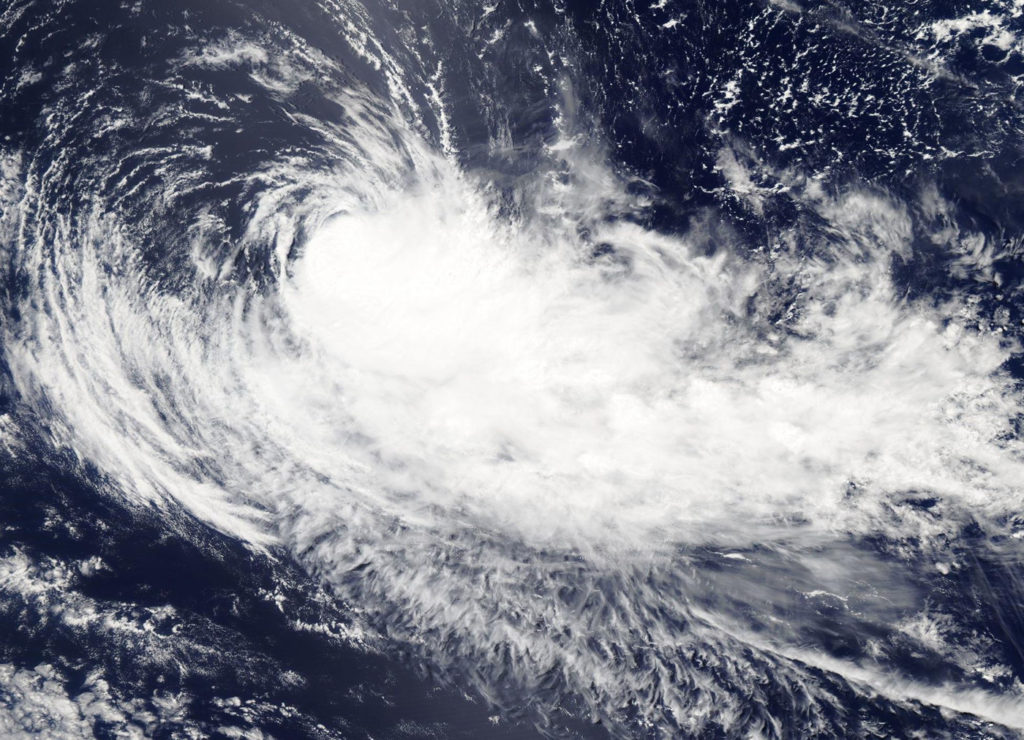
MODIS image of Gelena
On Feb. 11, 2019, the MODIS instrument aboard NASA’s Aqua satellite captured a visible light image of Tropical Cyclone Gelena in the Southern Indian Ocean. Wind shear pushed the bulk of clouds and storms east of the center. Credit: NASA Worldview, Earth Observing System Data and Information System (EOSDIS)

On Feb. 11, 2019, the Moderate Resolution Imaging Spectroradiometer or MODIS instrument aboard NASA’s Aqua satellite captured a visible image of Tropical Cyclone Gelena. Westerly wind shear pushed the bulk of clouds and storms east of the center. Wind shear is a measure of how the speed and direction of winds change with altitude.

At 10 a.m. EDT (1500 UTC) on Feb. 11, Gelena was located near 24.6 degrees south latitude and 70.3 east longitude, approximately 745 nautical miles east-southeast of Port Louis, Mauritius. Gelena was moving to the southeast. Maximum sustained winds were near 55 knots (63 mph/102 kph).

Forecasters at the Joint Typhoon Warning Center expect Gelena to dissipate in three days, by February 14.

By Rob Gutro
NASA’s Goddard Space Flight Center

Gelena (Southern Indian Ocean)

Feb. 8, 2019 – NASA’s Aqua Satellite Finds Tropical Cyclone Gelena’s Strongest Side

NASA’s Aqua satellite passed over the Southern Indian Ocean and captured an infrared image of Tropical Cyclone Gelena that revealed strongest storms were northwest of the eye.

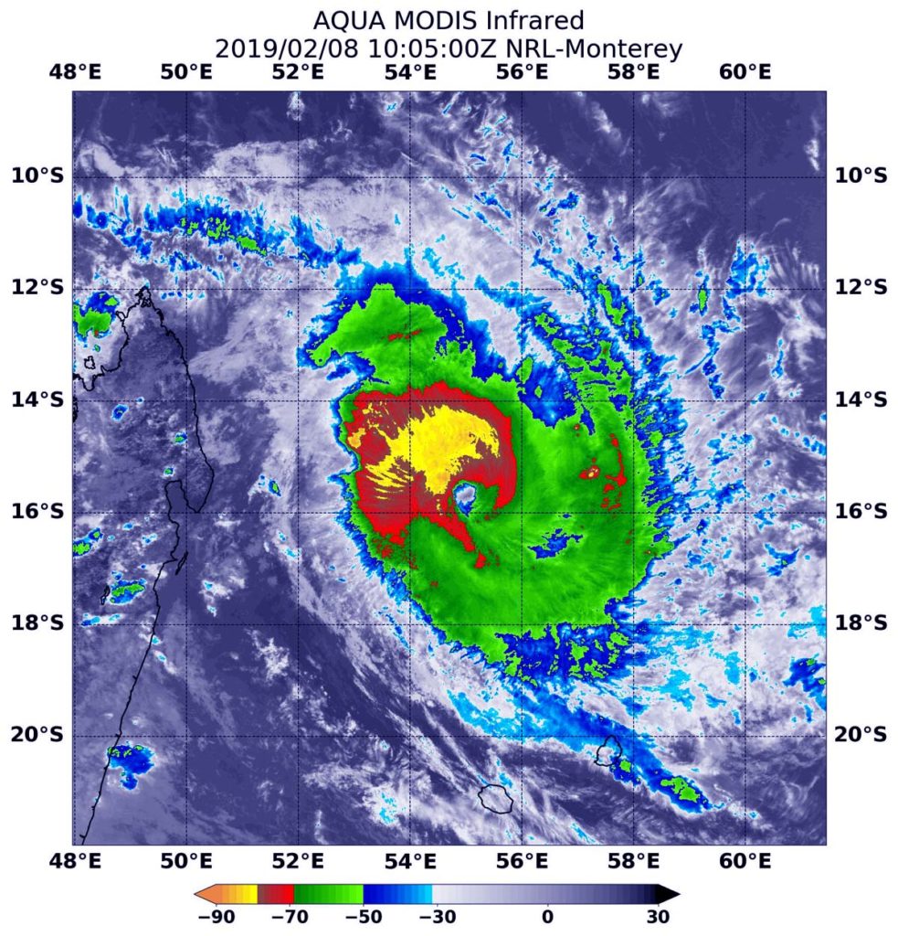
Satellite image of storm Gelena
At 5:05 a.m. EST (1005 UTC) on Feb. 8, the MODIS instrument that flies aboard NASA’s Aqua satellite gathered infrared data on Tropical Cyclone Gelena. Strongest thunderstorms were in the northwestern quadrant of the storm, where cloud top temperatures were as cold as minus 80 degrees Fahrenheit (minus 62 Celsius) and appear in yellow in this false colored image. Credit: NASA/NRL

On Feb. 8, a tropical cyclone warning class 2 is in force at Mauritius and Rodrigues.

At 5:05 a.m. EST (1005 UTC) on Feb. 8 the MODIS instrument that flies aboard NASA’s Aqua satellite gathered infrared data on Tropical Cyclone Gelena. Infrared data provides temperature information. MODIS found coldest cloud top temperatures as cold as minus 80 degrees Fahrenheit (minus 62 Celsius) in storms in the northwestern quadrant, outside of the eye. NASA research has shown that cloud tops with temperatures that cold were high in the troposphere and have the ability to generate heavy rain.

At 10 a.m. EDT (1500 UTC), the center of Tropical Cyclone Gelena was located near latitude 15.7 degrees south and longitude 55.3 degrees east. That’s about 288 nautical miles north-northwest of Port Louis, Mauritius. Maximum sustained winds were near 105 knots (121 mph/194.5 kph) and strengthening.

The Joint Typhoon Warning Center noted that Gelena will strengthen to 130 knots (149.6 /241 kph) within 24 hours. Although a weakening trend will then begin, Gelena is forecast to have winds of about 120 knots (138 mph/222 kph) upon closest approach to Rodrigues on Feb. 9.

Rob Gutro
NASA’s Goddard Space Flight Center, Greenbelt, Md.

Gelena (Southern Indian Ocean)

Feb. 7, 2019 – NASA Satellite Shows Tropical Cyclone Gelena Near Madagascar

A visible-light image from NASA’s Terra satellite revealed Tropical Cyclone Gelena was strengthening off the northeastern coast of Madagascar.

Satellite image of Gelena
On Feb. 7, 2019, the MODIS instrument aboard NASA’s Terra satellite provided a visible-light image of Tropical Cyclone Gelena in the Southern Indian Ocean. The image showed thunderstorms wrapping into the low-level center. Credit: NASA Worldview, Earth Observing System Data and Information System (EOSDIS)
High-resolution Link: https://go.nasa.gov/2HYKvru

On Feb. 7, 2019, the Moderate Resolution Imaging Spectroradiometer, or MODIS, instrument aboard NASA’s Terra satellite captured a visible image of Tropical Cyclone Gelena. The visible-light image showed bands of thunderstorms wrapping into what the Joint Typhoon Warning Center called “an intermittent eye feature.” The western quadrant had the bulk of clouds and thunderstorms that extended to the northern tip of Madagascar.

At 10 a.m. EDT (1500 UTC) on Feb. 7, Gelena was located near 13.1 degrees south latitude and 53.7 east longitude, approximately 453 nautical miles north-northwest of St. Denis, La Reunion Island. Gelena was moving to south-southeast. Maximum sustained winds were near 75 knots (86 mph/139 kph). Gelena is a Category 1 hurricane on the Saffir-Simpson hurricane scale.

Forecasters at the Joint Typhoon Warning Center expect Gelena to strengthen rapidly while moving southeast. Gelena is forecast to move away from Madagascar over the next several days, but will pass close enough to Mauritius for the island to feel the tropical cyclone’s effects.

The storm will peak at 120 knots (138 mph/222 kph) upon closest approach to Rodrigues on Saturday, Feb. 9.

Rob Gutro
NASA’s Goddard Space Flight Center

Gelena (Southern Indian Ocean)

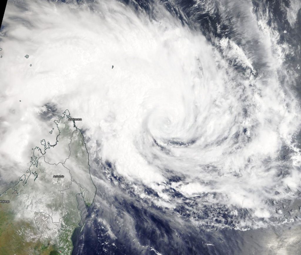
Feb. 6, 2019 – NASA Catches Development of Tropical Cyclone Gelena

Visible-light imagery from NASA’s Aqua satellite revealed the development of Tropical Depression 13S into a tropical storm. Tropical Storm Gelena intensified rapidly and appeared to have a cloud-filled eye.

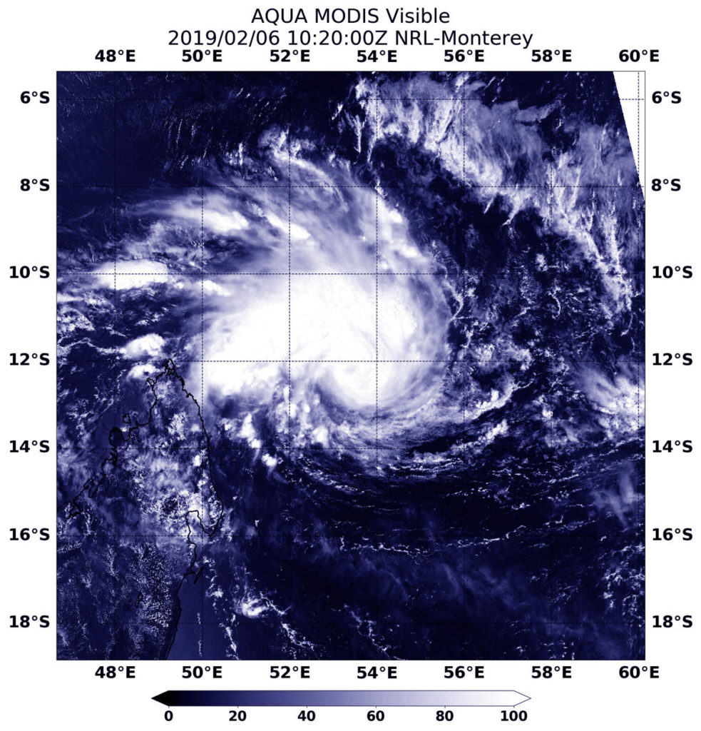
At 5:20 a.m. EDT (1020 UTC) on Feb. 6 the Moderate Resolution Imaging Spectroradiometer, or MODIS, instrument aboard NASA’s Aqua satellite provided a visible image of Tropical Storm Gelena in the Southern Indian Ocean. The image showed the storm developing an eye, with bands of thunderstorms wrapping into the low-level center.

image of Gelena
At 5:20 a.m. EDT (1020 UTC) on Feb. 6, 2019, the MODIS instrument aboard NASA’s Aqua satellite provided a visible image of Tropical Storm Gelena in the Southern Indian Ocean. The image showed the storm developing an eye, with bands of thunderstorms wrapping into the low-level center. Credit: NASA/NRL

At 10 a.m. EDT (1500 UTC) on Feb. 6, the Joint Typhoon Warning Center or JTWC noted that Trami had maximum sustained winds near 45 knots (52 mph/83 kph). It was centered near 12.3 degrees south latitude and 53.4 degrees east longitude. That’s 504 nautical miles north-northwest of St. Denis, La Reunion Island.

JTWC has forecast Gelena to strengthen rapidly and will eventually turn to the southeast. It is expected to reach hurricane-strength upon approach to Rodrigues, on Feb. 9.

Rob Gutro
NASA’s Goddard Space Flight Center, Greenbelt, Md.