Sergio (Eastern Pacific Ocean) 2018

Oct. 12, 2018 – NASA Sees Sergio’s Rains Sweep into the U.S. Southwest

NASA’s Aqua satellite captured an infrared image of Tropical Storm Sergio’s clouds and rainfall sweeping into the southwestern U.S.

Aqua image of Sergio
At 1:55 a.m. EDT (0555 UTC) on Oct. 3, the MODIS instrument that flies aboard NASA’s Aqua satellite gathered infrared data on Hurricane Leslie. Strongest thunderstorms circled the center and were in a thick band northeast of center where cloud top temperatures were as cold as minus 63 degrees Fahrenheit (minus 53 Celsius). Credit: NASA/NRL

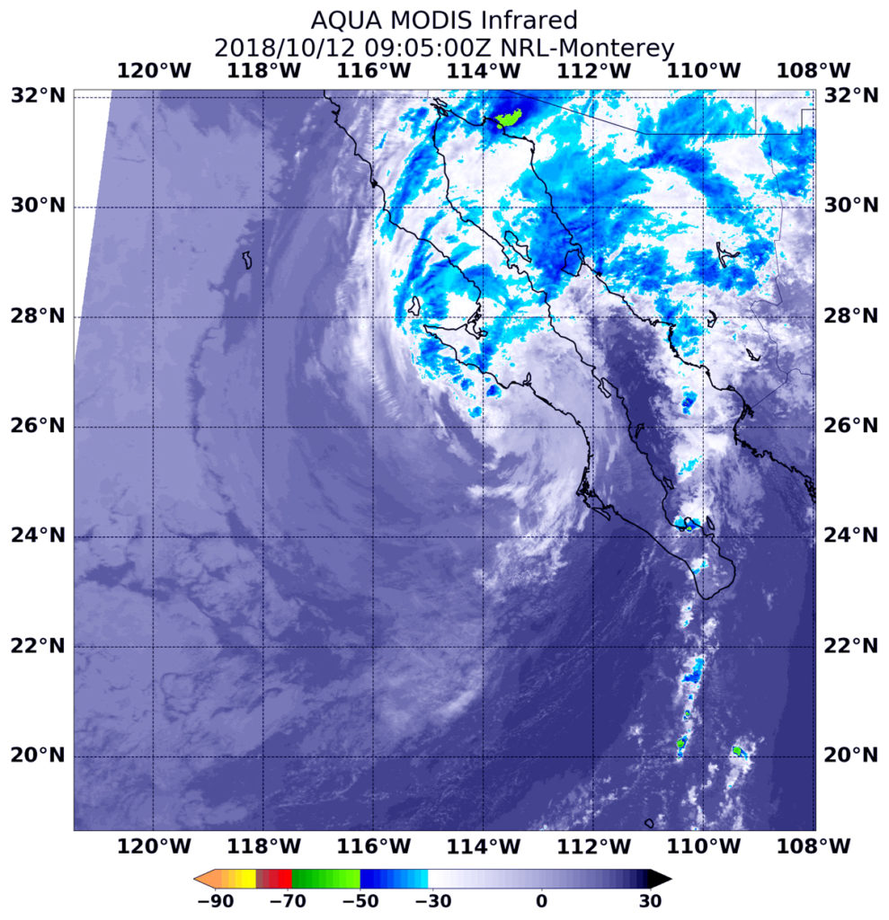
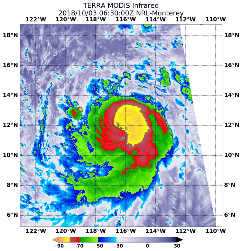
At 5:05 a.m. EDT (0905 UTC) on Oct. 3 the MODIS instrument that flies aboard NASA’s Aqua satellite gathered infrared data on Sergio. Although the center of circulation was over Baja California, Mexico, clouds and showers in the northeastern quadrant extended into southern Arizona.

Infrared data provides temperature information. MODIS found strongest storms with coldest cloud top temperatures as cold as minus 63 degrees Fahrenheit (minus 53 Celsius) in a small area in northwestern Mexico. NASA research has shown that cloud tops with temperatures that cold were high in the troposphere and have the ability to generate heavy rain.  A large area of storms with cloud top temperatures near minus 50 degrees Fahrenheit blanketed most of Baja California, northwestern mainland Mexico and stretched into southern Arizona.

Soon after Aqua passed overhead, Sergio entered the Sea of Cortez, located between Baja California and mainland Mexico.

At 11 a.m. EDT on Oct. 12, a Tropical Storm Warning is in effect for the west coast of the Baja California peninsula from Punta Eugenia to Cabo San Lazaro and for the east coast of the Baja California peninsula from Mulege to Bahia San Juan Bautista.

The National Hurricane Center or NHC noted the center of Tropical Storm Sergio was located near latitude 27.5 North, longitude 111.9 West. Sergio is moving toward the northeast near 24 mph (39 kph), and this general motion is expected to continue during the next day or so.  On the forecast track, the center of Sergio will move across the Sea of Cortez during the next several hours and then move over northwestern Mexico later today or tonight. Maximum sustained winds are near 40 mph (65 kph) with higher gusts.

Sergio should weaken to a tropical depression later today, and degenerate into a remnant low while moving over northwestern Mexico. Dissipation should occur on Saturday.

Despite dissipation as a tropical cyclone, though, the NHC said “moisture from Sergio will affect the United States, with total rain accumulations of 1 to 3 inches from southeast Arizona and southern New Mexico toward the southern Plains through Saturday. This rainfall could cause life-threatening flash flooding.”

For updated forecasts, visit: www.nhc.noaa.gov

By Rob Gutro
NASA’s Goddard Space Flight Center


Sergio (Eastern Pacific Ocean) 2018

Oct. 11, 2018 – NASA Provides Takes Powerful Hurricane Sergio’s Temperature

Infrared light provides scientists with temperature data and that’s important when trying to understand the strength of storms. NASA’s Aqua satellite provided those cloud top temperatures of Category 4 Hurricane Sergio in the Eastern Pacific Ocean.

Suomi NPP image of Sergio
The AIRS instrument aboard NASA’s Aqua satellite passed over Hurricane Sergio on Oct. 3 at 5:17 a.m. EDT (0917 UTC) and analyzed the storm in infrared light. AIRS detected strongest storms (purple) around the eye where cloud top temperatures were as cold as or colder than 207 Kelvin (minus 87 degrees Fahrenheit/minus 66.1 degrees Celsius). Credit: NASA JPL, Heidar Thrastarson

The Atmospheric Infrared Sounder or AIRS instrument aboard NASA’s Aqua satellite passed over Hurricane Sergio on Oct. 3 at 5:17 a.m. EDT (0917 UTC) and analyzed the storm in infrared light. The higher the cloud tops, the colder and the stronger the storms. Infrared light as that gathered by the AIRS instrument can identify the strongest sides of a tropical cyclone.

AIRS temperature data showed Sergio had intensified that morning, with the eye becoming better defined while embedded in very cold cloud tops. AIRS detected those very cold cloud tops were as cold as or colder than 207 Kelvin (minus 87 degrees Fahrenheit/minus 66.1 degrees Celsius).  Storms with cloud top temperatures that cold have the capability to produce heavy rainfall.

At 5 a.m. EDT (0900 UTC) on Thursday, Oct. 4 the National Hurricane Center or NHC noted “Sergio’s intensity is estimated to have increased just a little more this morning, and it remains a powerful category 4 hurricane.”

The eye of Hurricane Sergio was located near latitude 14.4 degrees north, longitude 118.8 degrees west. That’s about 825 miles (1,330 km) southwest of the southern tip of Baja California, Mexico. Sergio was moving toward the northwest near 8 mph (13 km/h), and this motion is expected to continue today.  A turn toward the west-northwest and west at a slightly slower forward speed is expected Friday and Saturday.

Maximum sustained winds are near 140 mph (220 kph) with higher gusts.  Sergio is a category 4 hurricane on the Saffir-Simpson Hurricane Wind Scale.

NHC noted “Little change in strength is expected during the next day or so, but gradual weakening is forecast to begin on Friday, [Oct. 5].”

For updated forecasts on Sergio, visit: www.nhc.noaa.gov

By Rob Gutro
NASA’s Goddard Space Flight Center

Sergio (Eastern Pacific Ocean) 2018

Oct. 10, 2018 – Tropical Storm Sergio’s Rainfall Examined by GPM Satellite

The Global Precipitation Measurement mission or GPM core satellite provided an analysis of the rate in which rain is falling throughout the Eastern Pacific Ocean’s Tropical Storm Sergio.  Sergio is close enough to Baja California now that it has triggered watches.

GPM image of Sergio
GPM measured rainfall within tropical storm Sergio on October 10, 2018 at 9:13 a.m. EDT (1313 UTC). Measurements indicated that the heaviest rainfall was north of Sergio’s eye like feature. Rain was shown to be falling at a rate of over 2.2 inches (55.9 mm) per hour in that part of the tropical storm. Credit: NASA/JAXA, Hal Pierce

A Tropical Storm Watch is in effect for the west coast of the Baja California peninsula from Punta Eugenia to Cabo San Lazaro, Mexico. A Tropical Storm Watch is also in effect for the east coast of the Baja California peninsula from Bahia San Juan Bautista to San Evaristo, Mexico. The National Hurricane Center or NHC said, “Interests elsewhere in the northern and central Baja California peninsula and northwestern Sonora should monitor the progress of Sergio.  Additional watches or warnings may be required on later tonight or Thursday, Oct. 11.”

The GPM core observatory satellite’s Microwave Imager (GMI) and Dual-Frequency Precipitation Radar (DPR) instruments measured rainfall within tropical storm Sergio on October 10, 2018 at 9:13 a.m. EDT (1313 UTC). GPM’s radar only viewed storms on the eastern side of Sergio while the GMI swath included storms around the center of circulation. Measurements by GMI indicated that the heaviest rainfall was north of Sergio’s eye like feature. Rain was shown by GMI to be falling at a rate of over 2.2 inches (55.9 mm) per hour in that part of the tropical storm. GPM is a joint mission between NASA and the Japan Aerospace Exploration Agency, JAXA.

That heavy rainfall is in the forecast as Sergio begins and continues its landfall. Sergio is expected to produce total storm rainfall accumulations of 3 to 5 inches, with local amounts of 10 inches across the central portion of the Baja California peninsula and Sonora.

At 2 p.m. EDT (1800 UTC), the center of Tropical Storm Sergio was located near latitude 18.6 degrees north and longitude 123.0 degrees west. Sergio is moving toward the northeast near 13 mph (20 kph). A northeastward motion with an increase in forward speed is expected during the next few days. Maximum sustained winds remain near 65 mph (100 kph) with higher gusts.  Some fluctuations in intensity are likely today, but gradual weakening is forecast during the next several days.

Sergio is being steered toward the northeast by a large mid-latitude trough or elongated area of low pressure. On the forecast track, the center of Sergio will approach the Pacific coast of Baja California Sur early Friday and then reach mainland Mexico late Friday. The National Hurricane Center (NHC) predicts that rainfall from Sergio and its remnants will produce life-threatening flash flooding and mudslides during the weekend when it passes over the mountainous terrain of northwestern Mexico, the Southern Plains, and the Ozarks.

For updated forecasts, visit: www.nhc.noaa.gov

By Rob Gutro / Hal Pierce
NASA’s Goddard Space Flight Center

Sergio (Eastern Pacific Ocean) 2018

Oct. 09, 2018 – NASA Checks Out Hurricane Sergio’s Cloud Temperature

NASA’s Aqua satellite peered into Hurricane Sergio with infrared light to determine if the storm was intensifying or weakening. Infrared data showed cloud top temperatures were getting warmer on the western half of the storm, indicating the uplift of air in storms had weakened.

AIRS image of Sergio
NASA’s Aqua satellite provided an infrared picture of Hurricane Sergio’s cloud top temperatures from Oct. 9 at 6:17 a.m. EDT (1017 UTC). Strongest storms circled the eye (purple) and appeared in fragmented bands of thunderstorms north and south of the center. Credit: NASA JPL, Heidar Thrastarson

The Atmospheric Infrared Sounder or AIRS instrument aboard NASA’s Aqua satellite passed over Hurricane Sergio on Oct. 9 at 6:17 a.m. EDT (1017 UTC). AIRS uses infrared light and infrared light provides scientists with temperature data and that’s important when trying to understand how strong storms can be. The higher the cloud tops, the colder and the stronger they are. So infrared light as that gathered by the AIRS instrument can identify the strongest areas of a tropical cyclone.

At the time Aqua passed overhead, coldest cloud top temperatures in thunderstorms circled the eye and appeared in fragmented bands of thunderstorms north and south of the center. Those temperatures were as cold as or colder than minus 63 degrees Fahrenheit (minus 53 degrees Celsius). The exception was on the western side of the storm, where cloud top temperatures were warming, meaning they were not getting as high in the atmosphere.

Despite the slow weakening the hurricane still has a large but well-defined inner-core in the low and mid-levels.

 The National Hurricane Center noted at 11 a.m. EDT (1500 UTC), the center of Hurricane Sergio was located near latitude 16.6 degrees north and longitude 127.4 degrees west. That’s 1,215 miles (1,960 km) west-southwest of the southern tip of Baja California, Mexico.

Sergio is moving toward the northeast near 7 mph (11 kph). A faster northeastward motion is expected for the next several days. Maximum sustained winds have decreased to near 80 mph (130 kph) with higher gusts.  Gradual weakening is anticipated during the next several days.

NHC noted that there are no coastal watches or warnings in effect, but interests in Baja California Sur should monitor the progress of Sergio.

More information about AIRS can be found at airs.jpl.nasa.gov

For updated forecasts, visit: www.nhc.noaa.gov

By Rob Gutro
NASA’s Goddard Space Flight Center


Sergio (Eastern Pacific Ocean) 2018

Oct. 05, 2018 – NOAA’s GOES-West Night-time View of Hurricane Sergio

Hurricane Sergio continued to look impressive on satellite imagery when NOAA’s GOES-West satellite viewed the storm in infrared light.

hurricane in blue with data bar
NOAA’s GOES-West satellite provided a night-time view of powerful Hurricane Sergio on Oct. 5 at 6:01 a.m. PDT (9:01 a.m. EDT/1301 UTC) in the Eastern Pacific Ocean. Sergio had a clear eye with powerful thunderstorms circling the center.  Credit: NOAA/NRL

NOAA’s GOES-West satellite sits at a fixed position in orbit and covers the western U.S. and the Eastern and Central Pacific Ocean. GOES satellites circle the Earth in a geosynchronous orbit, which means they orbit the equatorial plane of the Earth at a speed matching the Earth’s rotation. This allows them to hover continuously over one position on the surface. NOAA’s GOES-West satellite provided a night-time view of powerful Hurricane Sergio on Oct. 5 at 6:01 a.m. PDT (9:01 a.m. EDT/1301 UTC) in the Eastern Pacific Ocean. The imagery showed that Sergio had a clear eye with powerful thunderstorms circling the center.

At 2 a.m. PDT (5 a.m. EDT/0900 UTC), the eye of Hurricane Sergio was located near latitude 16.0 degrees north and longitude 121.2 degrees west.  Sergio is moving toward the west-northwest near 8 mph (13 kph). A turn toward the west and west-southwest at a similar speed is expected during the next 24 hours.  Sergio should then turn back to the west and northwest over the weekend. Maximum sustained winds have decreased to near 120 mph (195 kph) with higher gusts. Sergio is a category 3 hurricane on the Saffir-Simpson Hurricane Wind Scale.  Additional gradual weakening is forecast during the next several days, but Sergio is expected to remain a hurricane through the middle of next week.

NOAA manages the GOES series of satellites and the NASA/NOAA GOES Project at NASA’s Goddard Space Flight Center in Greenbelt, Maryland, is responsible for building and launching the GOES satellites.

For updated forecasts, visit: www.nhc.noaa.gov

By Rob Gutro
NASA Goddard Space Flight Center

Sergio (Eastern Pacific Ocean) 2018

Oct. 04, 2018 – NASA Takes Powerful Hurricane Sergio’s Temperature

Infrared light provides scientists with temperature data and that’s important when trying to understand the strength of storms. NASA’s Aqua satellite provided those cloud top temperatures of Category 4 Hurricane Sergio in the Eastern Pacific Ocean.

AIRS image of Sergio
The AIRS instrument aboard NASA’s Aqua satellite passed over Hurricane Sergio on Oct. 3 at 5:17 a.m. EDT (0917 UTC) and analyzed the storm in infrared light. AIRS detected strongest storms (purple) around the eye where cloud top temperatures were as cold as or colder than 207 Kelvin (minus 87 degrees Fahrenheit/minus 66.1 degrees Celsius). Credit: NASA JPL, Heidar Thrastarson

The Atmospheric Infrared Sounder or AIRS instrument aboard NASA’s Aqua satellite passed over Hurricane Sergio on Oct. 3 at 5:17 a.m. EDT (0917 UTC) and analyzed the storm in infrared light. The higher the cloud tops, the colder and the stronger the storms. Infrared light as that gathered by the AIRS instrument can identify the strongest sides of a tropical cyclone.

AIRS temperature data showed Sergio had intensified that morning, with the eye becoming better defined while embedded in very cold cloud tops. AIRS detected those very cold cloud tops were as cold as or colder than 207 Kelvin (minus 87 degrees Fahrenheit/minus 66.1 degrees Celsius).  Storms with cloud top temperatures that cold have the capability to produce heavy rainfall.

At 5 a.m. EDT (0900 UTC) on Thursday, Oct. 4 the National Hurricane Center or NHC noted “Sergio’s intensity is estimated to have increased just a little more this morning, and it remains a powerful category 4 hurricane.”

The eye of Hurricane Sergio was located near latitude 14.4 degrees north, longitude 118.8 degrees west. That’s about 825 miles (1,330 km) southwest of the southern tip of Baja California, Mexico. Sergio was moving toward the northwest near 8 mph (13 km/h), and this motion is expected to continue today.  A turn toward the west-northwest and west at a slightly slower forward speed is expected Friday and Saturday.

Maximum sustained winds are near 140 mph (220 kph) with higher gusts.  Sergio is a category 4 hurricane on the Saffir-Simpson Hurricane Wind Scale.

NHC noted “Little change in strength is expected during the next day or so, but gradual weakening is forecast to begin on Friday, [Oct. 5].”

For updated forecasts on Sergio, visit: www.nhc.noaa.gov

By Rob Gutro
NASA’s Goddard Space Flight Center

Sergio (Eastern Pacific Ocean) 2018

Oct. 03, 2018 – NASA Sees Powerful Storms Circling Major Hurricane Sergio’s Eye

Very powerful storms ringed the eye of Hurricane Sergio in infrared imagery from NASA’s Aqua satellite. Sergio is a major hurricane in the Eastern Pacific Ocean.

Aqua image of Sergio
At 2:30 a.m. EDT (0630 UTC) on Oct. 3, the MODIS instrument that flies aboard NASA’s Aqua satellite gathered infrared data on Hurricane Sergio. Strongest thunderstorms circled the center where cloud top temperatures were as cold as (yellow) minus 80 degrees Fahrenheit (minus 62.2 Celsius). Credit: NASA/NRL

At 2:30 a.m. EDT (0630 UTC) on Oct. 3 the MODIS instrument that flies aboard NASA’s Aqua satellite gathered infrared data on Sergio.  Infrared data provides temperature information.

Strongest thunderstorms wit coldest cloud tops appeared in the eyewall of the hurricane and extended outward from the center. MODIS found cloud top temperatures as cold as minus 80 degrees Fahrenheit (minus 62.2 Celsius). NASA research has shown that cloud tops with temperatures that cold were high in the troposphere and have the ability to generate heavy rain.

The National Hurricane Center or NHC noted at 5 a.m. EDT (0900 UTC), the center of Hurricane Sergio was located near latitude 12.3 degrees north and longitude 116.7 degrees west. Sergio is moving toward the west-northwest near 12 mph (19 kph). Fortunately, Sergio is far from land areas. It is about 855 miles (1,380 km) south-southwest of the southern tip of Baja California, Mexico.

A west-northwestward to northwestward motion at a slightly slower forward speed is expected over the next few days. Maximum sustained winds are near 115 mph (185 kph) with higher gusts.  Sergio is a category 3 hurricane on the Saffir-Simpson Hurricane Wind Scale.

Some strengthening is forecast during the next day or so, with weakening expected to begin by Friday.

For updated forecasts on Sergio, visit: www.nhc.noaa.gov

By Rob Gutro
NASA’s Goddard Space Flight Center

Sergio (Eastern Pacific Ocean)

Oct. 02, 2018 – NASA Finds Tropical Storm Sergio on the Verge of Hurricane Status

The National Hurricane Center noted that Tropical Storm Sergio was on the verge of becoming a hurricane in the Eastern Pacific Ocean and NASA’s Aqua satellite confirmed very powerful storms within.

Aqua image of Sergio
Infrared satellite data captured at 5:30 a.m. EDT (0930 UTC) on Oct. 1 from NASA’s Aqua satellite revealed strongest storms with the coldest cloud top temperatures west of Sergio’s center and in a band of thunderstorms southwest of the center. MODIS found coldest cloud tops had temperatures near minus 70 degrees Fahrenheit (minus 56.6 degrees Celsius). Credit: NASA/NRL

Infrared satellite data captured at 5:30 a.m. EDT (0930 UTC) on Oct. 1 from the Moderate Resolution Imaging Spectroradiometer or MODIS instrument aboard NASA’s Aqua satellite revealed strongest storms with the coldest cloud top temperatures west of Sergio’s center and in a band of thunderstorms southwest of the center.  MODIS found coldest cloud tops had temperatures near minus 70 degrees Fahrenheit (minus 56.6 degrees Celsius). NASA research has found that cloud top temperatures that cold have the capability to generate heavy rainfall.

At 11 a.m. EDT, the National Hurricane Center or NHC noted “Sergio is almost a hurricane. Satellite images indicate that the central convection has been increasing in intensity during the past several hours, but there are still no indications of an eye in that data.  Microwave imagery does show an eye feature, however. The outer bands are not particularly well organized, and there are some dry slots beyond the inner core.”

The center of Tropical Storm Sergio was located near latitude 11.5 degrees north and longitude 109.5 degrees west.  Sergio is far from land, so there are no coastal advisories in effect. It is about 625 miles (1,000 km) southwest of Manzanillo, Mexico. Sergio is moving toward the west near 14 mph (22 kph), and this general motion is forecast to continue through tonight.  A turn toward the west-northwest is expected on Tuesday. Maximum sustained winds remain near 70 mph (110 kph) with higher gusts.

NHC noted that “Strengthening is expected during the next 48 hours, and Sergio is forecast to become a hurricane later today, and a major hurricane by Wednesday, Oct. 3.”

For updated forecasts, visit: www.nhc.noaa.gov

By Rob Gutro (with information from the NHC)
NASA Goddard Space Flight Center

Sergio (Eastern Pacific Ocean)

Oct. 01, 2018 – NASA Finds Tropical Storm Sergio on the Verge of Hurricane Status

The National Hurricane Center noted that Tropical Storm Sergio was on the verge of becoming a hurricane in the Eastern Pacific Ocean and NASA’s Aqua satellite confirmed very powerful storms within.

Aqua image of Sergio
Infrared satellite data captured at 5:30 a.m. EDT (0930 UTC) on Oct. 1 from NASA’s Aqua satellite revealed strongest storms with the coldest cloud top temperatures west of Sergio’s center and in a band of thunderstorms southwest of the center. MODIS found coldest cloud tops had temperatures near minus 70 degrees Fahrenheit (minus 56.6 degrees Celsius). Credit: NASA/NRL

Infrared satellite data captured at 5:30 a.m. EDT (0930 UTC) on Oct. 1 from the Moderate Resolution Imaging Spectroradiometer or MODIS instrument aboard NASA’s Aqua satellite revealed strongest storms with the coldest cloud top temperatures west of Sergio’s center and in a band of thunderstorms southwest of the center.  MODIS found coldest cloud tops had temperatures near minus 70 degrees Fahrenheit (minus 56.6 degrees Celsius). NASA research has found that cloud top temperatures that cold have the capability to generate heavy rainfall.

At 11 a.m. EDT, the National Hurricane Center or NHC noted, “Sergio is almost a hurricane. Satellite images indicate that the central convection has been increasing in intensity during the past several hours, but there are still no indications of an eye in that data.  Microwave imagery does show an eye feature, however. The outer bands are not particularly well organized, and there are some dry slots beyond the inner core.”

The center of Tropical Storm Sergio was located near latitude 11.5 degrees north and longitude 109.5 degrees west.  Sergio is far from land, so there are no coastal advisories in effect. It is about 625 miles (1,000 km) southwest of Manzanillo, Mexico. Sergio is moving toward the west near 14 mph (22 kph), and this general motion is forecast to continue through tonight.  A turn toward the west-northwest is expected on Tuesday. Maximum sustained winds remain near 70 mph (110 kph) with higher gusts.

NHC noted that “Strengthening is expected during the next 48 hours, and Sergio is forecast to become a hurricane later today, and a major hurricane by Wednesday, Oct. 3.”

For updated forecasts, visit: www.nhc.noaa.gov

By Rob Gutro (with information from the NHC)
NASA Goddard Space Flight Center