Marco (was TD14) – Atlantic Ocean

Sep. 01, 2020 – NASA’s IMERG Analyzed Heavy Rains from Hurricanes Laura and Marco 

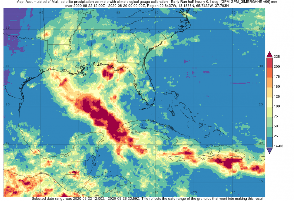
The northern Gulf Coast, specifically Louisiana, saw two tropical cyclones make landfall in the same week just days apart. NASA’s IMERG surface rainfall accumulations were calculated for the period 22 to 27 August 2020 for both Hurricanes Marco and Laura. The two systems, however, could not have been more different when they arrived.
IMERG data on Marco and Laura
IMERG data on Marco and Laura. Image credit: NASA/JAXA/IMERG, Steve Lang

Marco’s History and Track

Despite forming a day later, Marco was the first system to make landfall on the Gulf Coast. Marco originated from a tropical easterly wave that was moving from the central to the western Caribbean. After becoming a tropical depression (TD) on August 20, TD #14 turned northwestward the following day as it approached the coast of Central America and moved into the northwest Caribbean.

According to the National Hurricane Center (NHC), TD #14 reached tropical storm intensity on the night of the 21st and named Marco. Marco remained over warm open water as it passed through the Yucatan Straight and into the Gulf of Mexico on the afternoon of the 22nd. Marco was now a strong tropical storm with sustained winds reported at 65 mph by NHC and seemed poised to intensify.

However, the warm waters were offset by the effects of southwesterly wind shear, which were to become a major inhibiting factor as Marco moved through the Gulf of Mexico.

Although the wind shear kept Marco from really intensifying, the warm Gulf waters supported enough convection for Marco to reach hurricane intensity around midday on Sunday the 23rd. By now Marco was in the central Gulf and moving north between a ridge of high pressure to the east and an upper-level trough over the western Gulf. However, as Marco continued northward the wind shear increased, pushing the thunderstorms that were fueling the system along with most of the rain away from the center off to the northeast, causing Marco to weaken back down to a tropical storm that very same evening.

On the 24th, as it neared the northern Gulf Coast, Marco continued to weaken and slow down as high pressure to the east built westward, blocking Marco’s path and forcing the cyclone to turn westward. The center of circulation just made landfall near the mouth of the Mississippi at 6:00 pm CDT on Monday the 24th with sustained winds reported at 40 mph by NHC before being shunted westward back over open water and weakening further. By now, the center was essentially devoid of thunderstorms with the bulk of the rain falling well east of the center.

NASA Rainfall Accumulations on Marco

IMERG surface rainfall accumulations were compiled for the period 22 to 27 August 2020 for the southeastern U.S., Gulf of Mexico, the northwest Caribbean and adjacent regions. Accumulations include the effects from both Laura and Marco. However, the rainfall due to Marco is evidenced by its north-south orientation and generally extends from the west-central Caribbean up through the Yucatan Strait and the eastern Gulf of Mexico and into the Florida Panhandle.

The heaviest rainfall totals due to Marco were just offshore and along the coast of the Florida Panhandle and reached up to 225 mm (~9 inches, shown in dark red) while a good portion of the Florida Panhandle is estimated to have received at least 75 to 100 mm (~3 to 4 inches, shown in bright green and yellow). Rainfall totals near the mouth of the Mississippi where the center made landfall are much lower and reflects the storm’s asymmetric structure due to the strong wind shear where most of the thunderstorms and associated rainfall occurred well northeast of the center.

Laura’s History and Track

Laura too originated from an easterly wave but began as TD #13 well out into the central tropical Atlantic on the night of August 19. Over the next couple of days, despite passing over warm water, TD #13 was held in check by a combination of mid-level wind shear and dry air that kept the system poorly organized. However, as it neared the Leeward Isles on the 21st, it finally reached minimum tropical storm intensity and named Laura.

Laura then passed through the Leeward Islands as a weak tropical storm later that same day. As it approached Puerto Rico on the 22nd, Laura was still unorganized, and although the wind shear abated, Laura was now inhibited by its close proximity to land. After passing very near the southwest coast of Puerto Rico, Laura crossed directly over the island of Hispaniola on the night of the 22nd; however, despite being over land, Laura continued to generate deep convection and emerged off the west coast of Haiti with sustained winds reported at 50 mph by NHC on the morning of the 23rd.

Laura gained a little strength before crossing over southeastern Cuba on the night of the 23rd; again, despite being over land, Laura continued to tap into the warm waters off the south coast of Cuba and actually intensified slightly. On the morning of the 24th, Laura re-emerged over open water south of Cuba.

At this point, another key factor came into play. The ridge of high pressure north of Laura that was steering the storm expanded westward, keeping the center well over water and further away from the south coast of Cuba. Despite this, northerly wind shear, drier air and some land interaction initially weakened the storm slightly as it paralleled the south coast of Cuba. However, as Laura neared and crossed western Cuba on the evening of the 24th, it was already showing signs of becoming better organized though it remained at tropical storm intensity.

When Laura emerged out into the southeast Gulf of Mexico early on the morning of the 25th, it did so over deep, warm water in a humid, relatively low wind-shear environment, the perfect conditions for intensification. Almost immediately, strong convection fired up near Laura’s core, lowering the central pressure, and by 7:15 a.m. CDT on Tuesday August 25th, Laura was a Category 1 hurricane. Now well organized and in ideal conditions for strengthening, Laura was primed for further, rapid intensification, which is exactly what happened.

Over the next 36 hours, as Laura gradually turned northward around the western edge of a high pressure ridge across Florida and headed for the northern Gulf Coast, it underwent a rapid deepening cycle. Reports from NHC showed that maximum sustained winds increased from 75 to 150 mph over this period, taking Laura from Category 1 to a Category 4 hurricane.

By this time, Laura was very near to the coast of western Louisiana where it then made landfall near Cameron, Louisiana at 1:00 a.m. CDT at the same 150 mph intensity. A wind gust to 128 mph was reported at the Lake Charles Regional Airport. It is estimated that Laura maintained hurricane intensity for the next 10 hours as it moved northward into northern Louisiana.

NASA Rainfall Accumulations on Laura

IMERG surface rainfall accumulations from Laura on the northern Gulf Coast were actually lower than they are for Marco and generally range from over 50 to 100 mm (~2 to 4 inches, shown in green and yellow) with local pockets of higher amounts (shown in orange) extending across most of Louisiana and Arkansas. Rainfall amounts depend more on system speed than intensity; while Marco slowed down near the coast, Laura continued to push northward. However, elsewhere in the Caribbean, IMERG estimates show from 125 to over 225 mm (~5 to over 9 inches, shown in orange and darker red) of rain over the southern half of Hispaniola, where a total of 35 fatalities were reported to due to the storm, 31 of which were in Haiti. So far, 22 deaths are being blamed on Laura in the US, 14 of those in Louisiana.

About IMERG

The near-real-time rain estimate comes from the NASA’s Integrated Multi-satellitE Retrievals for GPM (IMERG) algorithm, which combines observations from a fleet of satellites, in near real time, to provide near-global estimates of precipitation every 30 minutes.  This satellite-based rain estimate is somewhat coarse in resolution and can miss short-lived, intense storm-cells, but the IMERG algorithm often does captures the large-scale features of storms wherever they form in the world.  While the United States is fortunate to have a network of ground radars that can provide higher-resolution precipitation estimates, in other parts of the world, notably over most of the world’s oceans, the IMERG rain estimate is an important reference point.

This near-real time rain estimate comes from the NASA’s IMERG algorithm, which combines observations from a fleet of satellites, in near-real time, to provide near-global estimates of precipitation every 30 minutes. By combining NASA precipitation estimates with other data sources, we can gain a greater understanding of major storms that affect our planet.

IMERG fills in the “blanks” between weather observation stations. IMERG satellite-based rain estimates can be compared to that from a National Weather Service ground radar.  Such good detection of large rain features in real time would be impossible if the IMERG algorithm merely reported the precipitation observed by the periodic overflights of various agencies’ satellites.  Instead, what the IMERG algorithm does is “morph” high-quality satellite observations along the direction of the steering winds to deliver information about rain at times and places where such satellite overflights did not occur.  Information morphing is particularly important over the majority of the world’s surface that lacks ground-radar coverage.

By Steve Lang
NASA’s Goddard Space Flight Center


Aug. 25, 2020 – NASA’s Terra Satellite Catches the Demise of Post-Tropical Cyclone Marco

NASA’s Terra satellite passed over the Gulf of Mexico early on Aug. 25 and found a very small area of convection from post-tropical cyclone Marco, northeast of its center. All watches and warnings have been dropped as the storm continues to weaken toward dissipation.
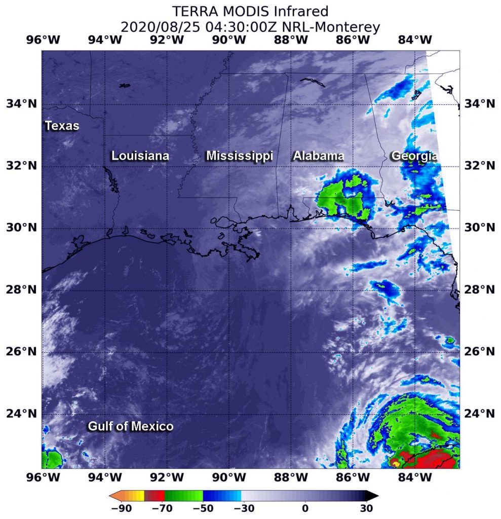
Terra image of Marco
On Aug. 25 at 12:30 a.m. EDT (0430 UTC), the MODIS instrument that flies aboard NASA’s Terra satellite gathered infrared data on post-tropical cyclone Marco that showed a small area of storms where cloud top temperatures were as cold as minus 50 degrees Fahrenheit (minus 45.5 Celsius). Credit: NASA/NRL

Visible imagery and surface observations indicated that Marco made landfall around 7 p.m. EDT on Aug. 24 near the mouth of the Mississippi River. The center continued to move west and moved offshore and south of Louisiana by Aug. 25.

NASA’s Terra Satellite Reveals Effects of Wind Shear 

NASA’s Terra satellite uses infrared light to analyze the strength of storms by providing temperature information about the system’s clouds. The strongest thunderstorms that reach high into the atmosphere have the coldest cloud top temperatures.

On Aug. 25 at 12:30 a.m. EDT (0430 UTC), the Moderate Resolution Imaging Spectroradiometer or MODIS instrument that flies aboard NASA’s Terra satellite observed Marco in infrared light and found a small area of storms where cloud top temperatures as cold as minus 50 degrees Fahrenheit (minus 45.5 Celsius) over the western Florida Panhandle and coastal Alabama. Those storms were being pushed northeast of Marco’s center from southwesterly wind shear. Satellite imagery also shows the low-level circulation center was a swirl of clouds south of Louisiana, over the Gulf of Mexico.

In the Aug. 25, Marco discussion at 5 a.m. EDT, NHC Senior Hurricane Specialist Stacy Stewart noted, “Marco has been devoid of any significant convection for at least 12 hours.  [NOAA’s Advanced Scatterometer] ASCAT scatterometer surface wind data around 0239Z (10:39 p.m. EDT on Aug. 24) suggested that Marco might have degenerated in a north-to-south elongated trough (elongated area of low pressure). Based on this information, Marco has been downgraded to post-tropical remnant low [pressure area].”

About Wind Shear  

The shape of a tropical cyclone provides forecasters with an idea of its organization and strength. When outside winds batter a storm, it can change the storm’s shape and push much of the associated clouds and rain to one side of it. That is what wind shear does.

In general, wind shear is a measure of how the speed and direction of winds change with altitude. Tropical cyclones are like rotating cylinders of winds. Each level needs to be stacked on top each other vertically in order for the storm to maintain strength or intensify. Wind shear occurs when winds at different levels of the atmosphere push against the rotating cylinder of winds, weakening the rotation by pushing it apart at different levels.

Marco’s Final Status

At 5 a.m. EDT (0900 UTC) on Aug. 25, NOAA’s National Hurricane Center (NHC) reported the center of Post-Tropical Cyclone Marco was located near latitude 28.8 degrees north and longitude 91.2 degrees west. That is about 60 miles (100 km) south of Morgan City, La. and 110 miles (175 km) south-southeast of Lafayette, La. The post-tropical cyclone was moving toward the west near 10 mph (17 kph), and this general motion is expected to continue for the next day or so. Maximum sustained winds were near 30 mph (45 kph) with higher gusts. The estimated minimum central pressure was 1008.

Marco Nears its End

Brisk southwesterly vertical wind shear of 30 knots is forecast to increase to near 35 knots in 24 hours, which should prevent the redevelopment of deep convection near the center. On the forecast track, Marco should continue moving westward just offshore the coast of Louisiana until the system dissipates.

NASA Researches Tropical Cyclones

Hurricanes/tropical cyclones are the most powerful weather events on Earth. NASA’s expertise in space and scientific exploration contributes to essential services provided to the American people by other federal agencies, such as hurricane weather forecasting.

For more than five decades, NASA has used the vantage point of space to understand and explore our home planet, improve lives and safeguard our future. NASA brings together technology, science, and unique global Earth observations to provide societal benefits and strengthen our nation. Advancing knowledge of our home planet contributes directly to America’s leadership in space and scientific exploration.

For updated forecasts. visit: www.nhc.noaa.gov

By Rob Gutro
NASA’s Goddard Space Flight Center

Marco – Atlantic Ocean

Aug. 24, 2020 – NASA Catches Tropical Storm Marco Weaker, But a Soaker

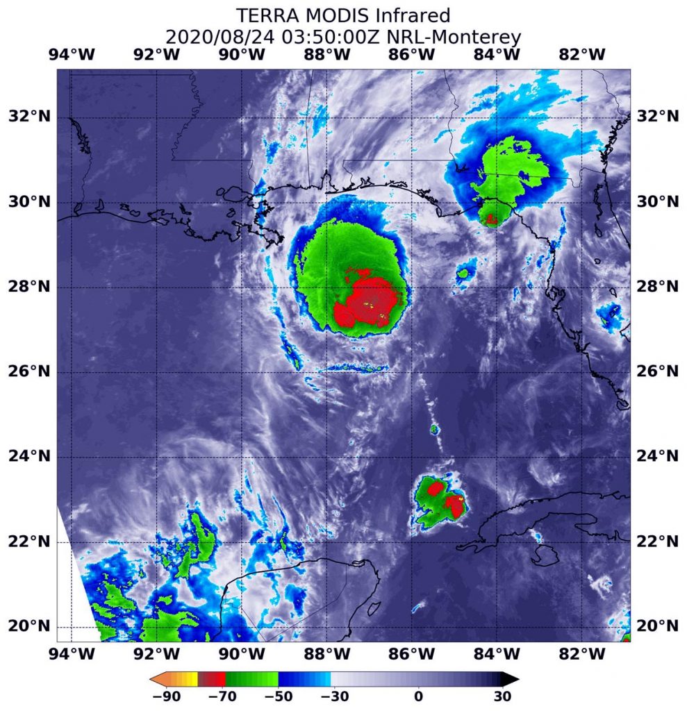
Although a weaker tropical storm on Monday, Aug. 24, Tropical Storm Marco continued to show its soaking capabilities in infrared data from NASA’s Terra satellite.

Terra image of Marco
On Aug. 23 at 11:50 p.m. EDT (Aug. 24 at 0350 UTC), the MODIS instrument aboard NASA’s Terra satellite gathered temperature information about Tropical Storm Marco’s cloud tops. MODIS found the most powerful thunderstorms (red) were northeast of the center where temperatures were as cold as or colder than minus 70 degrees Fahrenheit (minus 56.6 Celsius). Credit: NASA/NRL

Marco is feeling the effect of strong southwesterly wind shear. On Aug. 23, the center, as identified by an Air Force Reserve Hurricane Hunter aircraft, was displaced to the southwest edge of the bulk of thunderstorms. That wind shear continues to affect and weaken Marco.

Aug. 24 Warnings and Watches

The National Hurricane Center (NHC) posted a Storm Surge Warning from Morgan City, Louisiana to Ocean Springs, Mississippi including Lake Borgne. NHC noted from Morgan City, La. to Ocean Springs, Miss., including Lake Borgne between 2 and 4 feet. NHC noted the deepest water will occur along the immediate coast in areas of onshore winds, where the surge will be accompanied by large and dangerous waves.  Surge-related flooding depends on the relative timing of the surge and the tidal cycle, and can vary greatly over short distances.

A Tropical Storm Warning is in effect from Intracoastal City to the Mississippi/Alabama border, Lake Pontchartrain, Lake Maurepas, and Metropolitan New Orleans.

Infrared Data Reveals Powerful Storms

On Aug. 23 at 11:50 p.m. EDT (Aug. 24 at 0350 UTC), the Moderate Resolution Imaging Spectroradiometer or MODIS instrument aboard NASA’s Terra satellite gathered temperature information about Tropical Storm Marco’s cloud tops. Infrared data provides temperature information, and the strongest thunderstorms that reach high into the atmosphere have the coldest cloud top temperatures.

MODIS found the most powerful thunderstorms were to the northeast of the center of circulation, where temperatures were as cold as or colder than minus 70 degrees Fahrenheit (minus 56.6 Celsius). Cloud top temperatures that cold indicate strong storms with the potential to generate heavy rainfall.

Heavy rainfall is reflected in the NHC forecast today. NHC said, “Marco is expected to produce total rainfall accumulations of 3 to 5 inches with isolated maximum amounts of 10 inches across portions of the northeast and north-central Gulf coast through Tuesday. This rainfall may result in areas of flash, urban and small stream flooding in the area.”

NOAA’s GOES-16 1 minute satellite data showed the surface center well displaced from the deep convection, and it appears that Marco is decoupling from its mid-level circulation to the northeast. That is a result of vertical wind shear, outside winds blowing at different levels of the atmosphere, battering the vertical structure of the storm and weakening it. The wind shear is expected to increase.

Marco’s Status on Aug. 24, 2020

At 8 a.m. EDT (1200 UTC) on Aug. 24, the center of Tropical Storm Marco was located near latitude 28.1 degrees north and longitude 88.4 degrees west. That is about 85 miles (135 km) south-southeast of the mouth of the Mississippi River. Marco was moving toward the northwest near 10 mph (17 kph). Data from an Air Force Reserve Hurricane Hunter aircraft indicate that maximum sustained winds have decreased to near 50 mph (80 kph) with higher gusts. The estimated minimum central pressure is 1005 millibars.  

Marco’s Forecast

In addition to tropical-storm-force winds and heavy rainfall, isolated tornadoes are possible today from southeast Louisiana to the western Florida Panhandle. In addition, swells generated by Marco are likely to affect portions of the northern Gulf Coast for the next couple of days. These swells are likely to cause life-threatening surf and rip current conditions.

Marco is forecast to approach the coast of Louisiana this afternoon, and then turn westward and move very close to the coast of Louisiana through Tuesday night. Further weakening is expected, and Marco is forecast to become a tropical depression late on Tuesday and dissipate on Wednesday.

About NASA’s Worldview

NASA’s Earth Observing System Data and Information System (EOSDIS) Worldview application provides the capability to interactively browse over 700 global, full-resolution satellite imagery layers and then download the underlying data. Many of the available imagery layers are updated within three hours of observation, essentially showing the entire Earth as it looks “right now.”

Tropical cyclones/hurricanes are the most powerful weather events on Earth. NASA’s expertise in space and scientific exploration contributes to essential services provided to the American people by other federal agencies, such as hurricane weather forecasting.

For updated forecasts, visit: www.nhc.noaa.gov

By Rob Gutro
NASA’s Goddard Space Flight Center

Marco – Atlantic Ocean

Aug. 23, 2020 – NASA-NOAA Satellite Finds Marco Nearing Hurricane Strength in the Southern Gulf

NASA-NOAA’s Suomi NPP satellite passed over Tropical Storm Marco early on Sunday, Aug. 23 and found the storm was nearing hurricane strength in the southern Gulf of Mexico.

Suomi NPP image of Marco
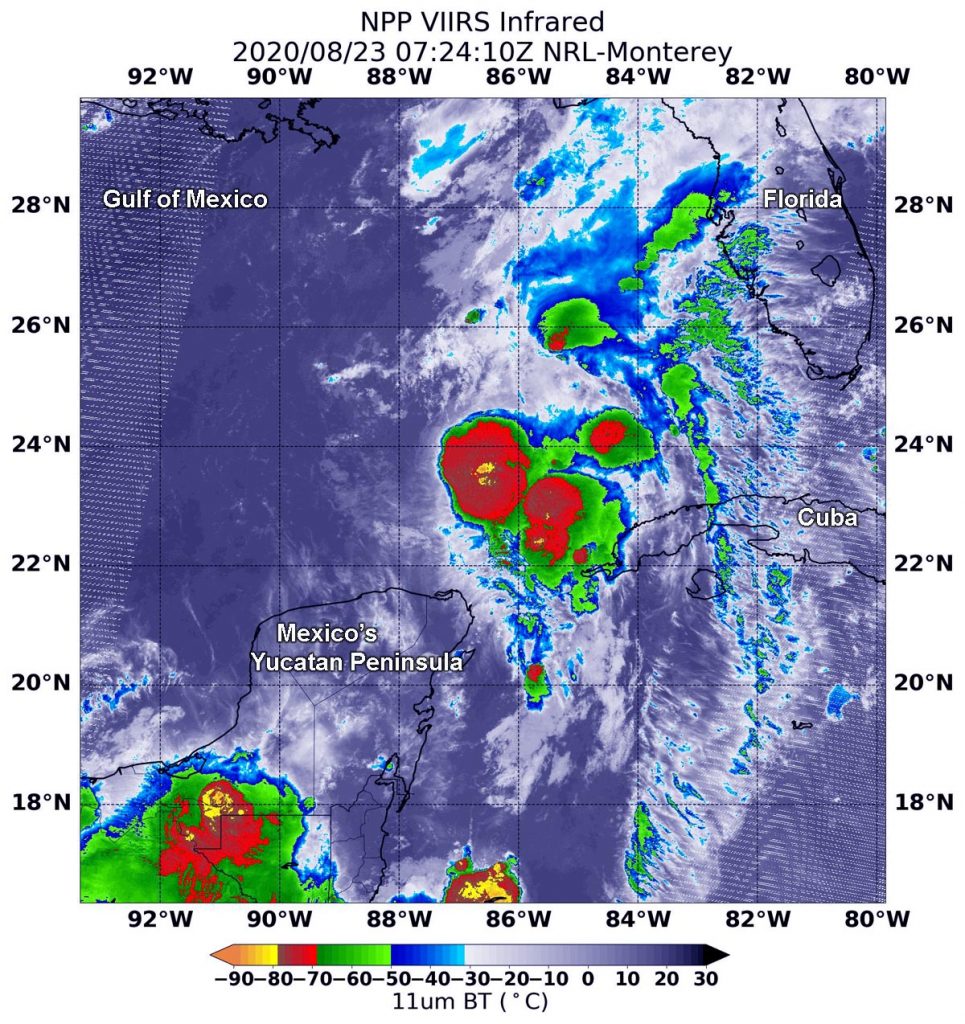
NASA-NOAA’s Suomi NPP satellite passed over Tropical Storm Marco now in the southern Gulf of Mexico. The VIIRS instrument aboard captured this image of the storm on Aug. 23 at 3:24 a.m. EDT (0724 UTC). There were several areas (yellow) within where cloud top temperatures were as cold as minus 80 degrees Fahrenheit (minus 62.2 Celsius), indicating powerful storms. Credit: NASA/NRL

Warnings and Watches in Effect as of Sunday, August 23, 2020

NOAA’s National Hurricane Center (NHC) in Miami, Fla. issued numerous watches and warnings along the Gulf Coast of the U.S. as Marco is forecast to move in that direction. A Storm Surge Warning is in effect from Morgan City, Louisiana to Ocean Springs, Mississippi including Lake Borgne. A Hurricane Warning is in effect for Morgan City Louisiana to the mouth of the Pearl River.

A Storm Surge Watch is in effect for Sabine Pass to Morgan City, Louisiana; Ocean Springs to the Alabama/Florida border; Lake Pontchartrain, Lake Maurepas, and Mobile Bay.

A Hurricane Watch is in effect from Intracoastal City, Louisiana to west of Morgan City; Lake Pontchartrain, Lake Maurepas, and Metropolitan New Orleans.

A Tropical Storm Warning is in effect from the mouth of the Pearl River to the Mississippi /Alabama border; Lake Pontchartrain, Lake Maurepas, and Metropolitan New Orleans. A Tropical Storm Watch is in effect from the Mississippi/Alabama border to the Alabama/Florida border.

Taking Marco’s Temperature

The Visible Infrared Imaging Radiometer Suite (VIIRS) instrument aboard Suomi NPP provided an infrared image of the storm on Aug. 23 at 3:24 a.m. EDT (0724 UTC). Infrared imagery reveals cloud top temperatures, and the higher the cloud top the colder it is and the stronger the storm.

The VIIRS instrument found several areas within where cloud top temperatures were as cold as minus 80 degrees Fahrenheit (minus 62.2 Celsius), indicating powerful storms. Marco continued to strengthen and consolidate. The most powerful thunderstorms were located around the center of circulation and in a fragmented band of thunderstorms. Storms with cloud tops that cold have been found to generate heavy rainfall.

At 4 a.m. EDT, NOAA’s National Hurricane Center noted, “Thunderstorm bursts continue to fire near the center of Marco, and then weaken an hour or two later due to persistent [vertical wind] shear. Overall, the storm’s appearance hasn’t changed with nearly all of the deep convection very near or northeast of the center.”

Marco’s Status on Sunday, August 23, 2020

At 8 a.m. EDT (1200 UTC) on Aug. 23, the center of Tropical Storm Marco was located near latitude 24.2 degrees north and longitude 87.1 degrees west. That is 210 miles (340 km) northwest of the western tip of Cuba, and about  360 miles (580 km) south-southeast of the mouth of the Mississippi River.  Marco is moving toward the north-northwest near 13 mph (20 kph). Maximum sustained winds are near 70 mph (110 kph) with higher gusts. The estimated minimum central pressure based on data from the Air Force Reserve Hurricane Hunter aircraft is 994 millibars.

NHC Key Messages on Marco

Hurricane conditions, life-threatening storm surge, and heavy rainfall are expected from Marco along portions of the Gulf Coast beginning on Monday, and Hurricane and Storm Surge Warnings have been issued.

In addition, Tropical Storm Laura could bring additional storm surge, rainfall, and wind impacts to portions of the U.S. Gulf Coast by the middle of next week. This could result in a prolonged period of hazardous weather for areas that may also be affected by Marco.

Marco’s Forecast

NHC hurricane forecaster Eric Blake noted, “The intensity forecast remains tricky with Marco due to its small size and marginal environment.  There are some models that briefly relax the shear today, which will likely be enough of a change to allow Marco to reach hurricane strength.”

Marco is forecast to continue moving north-northwestward across the central Gulf of Mexico today and will approach southeastern Louisiana on Monday. Some strengthening is anticipated and Marco is forecast to become a hurricane later today and be at hurricane strength when it approaches the northern Gulf Coast on Monday. A gradual turn toward the west with a decrease in forward speed is expected after Marco moves inland on Monday and on Tuesday.

Typhoons/ hurricanes are the most powerful weather events on Earth. NASA’s expertise in space and scientific exploration contributes to essential services provided to the American people by other federal agencies, such as hurricane weather forecasting.

For updated forecasts and details about storm surge, rainfall and winds, visit:  www.nhc.noaa.gov

By Rob Gutro 
NASA’s Goddard Space Flight Center

Marco (was TD14) – Atlantic Ocean

Aug. 22, 2020 – NASA-NOAA Satellite Finds Tropical Storm Marco Organizing Between Cuba and Mexico

Nighttime imagery from NASA-NOAA’s Suomi NPP satellite provided forecasters a look at the more organized structure of Tropical Storm Marco as it moved toward the Yucatan Straits on a journey to the Gulf of Mexico.

Suomi NPP nighttime image of Marco
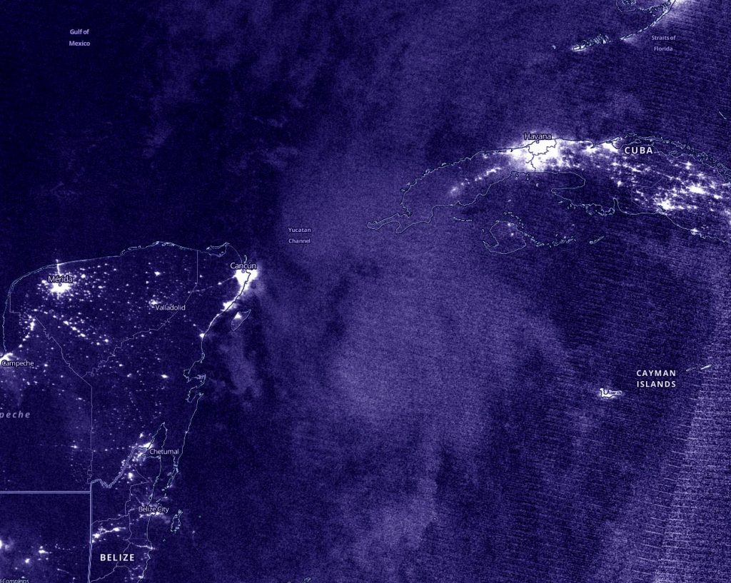
NASA-NOAA’s Suomi NPP satellite passed the Caribbean Sea in the early morning hours of Aug. 22 and captured a nighttime image of Tropical Storm Marco as it was moving between Mexico’s Yucatan Peninsula (left) and Cuba (right). Both countries were lit up by bright city nights. Credit: NASA Worldview, Earth Observing System Data and Information System (EOSDIS)

Early on Aug. 21, Tropical Depression 14 was getting organized in the Caribbean Sea. It maintained depression status until the end of the day, when it strengthened.

NOAA’s Hurricane Hunter aircraft passed over Tropical Depression 14 at 11 p.m. EDT and reported that deep convection had increased near and to the east of Marco’s center during the past few hours. Although there still was not much evidence of inner-core banding of thunderstorms around the center, the data from the plane indicated that the center of Marco had become better defined since the afternoon and that the minimum pressure has dropped. Thus, the depression was categorized as a tropical storm.

Night Imagery Shows Marco Organizing

During the early morning hours of Aug. 22, the Visible Infrared Imaging Radiometer Suite (VIIRS) instrument aboard NASA-NOAA’s Suomi NPP satellite provided an infrared image of Tropical Storm Marco. The imagery showed the center of Marco was south of the Yucatan Channel, the body of water between the Yucatan Peninsula and western Cuba. A band of thunderstorms north of the center extended over the channel.

By 5 a.m. EDT, U.S. Navy Hurricane Specialist Dave Roberts noted, “The cloud pattern has improved during the past several hours with deep convection developing near the center and spiral bands forming over the eastern portion of cyclone.”

Imagery from NASA-NOAA’s Suomi NPP satellite was created using the NASA Worldview application at NASA’s Goddard Space Flight Center in Greenbelt, Md.

Watches and Warnings Now in Effect

NOAA’s National Hurricane Center (NHC) has posted many watches and warnings for Marco on Aug. 22. A Hurricane Watch is in effect from Punta Herrero to Cancun, Mexico and a Tropical Storm Warning is in effect from Punta Herrero to Dzilam, Mexico.

Tropical Storm Marco’s Status on Aug. 22

At 8 a.m. EDT (1200 UTC) on Aug. 22, the center of Tropical Storm Marco was located near latitude 20.2 degrees north and longitude 85.2 degrees west. It was just 110 miles (180 km) east of Cozumel, Mexico.  Marco was moving toward the north-northwest near 12 mph (19 km/h).  A northwestward motion is expected on Sunday, followed by a turn toward the northwest and west-northwest early next week.

Data from an Air Force Reserve Hurricane Hunter aircraft indicated that maximum sustained winds had increased to near 50 mph (85 kph) with higher gusts. The estimated minimum central pressure was 1002 millibars.

Marco’s Forecast Track

On the forecast track, the center of Marco will approach the eastern coast of the Yucatan Peninsula of Mexico today.  Additional strengthening is forecast during the next couple of days as the system approaches the Yucatan Peninsula, and Marco could be near hurricane strength when it moves over the central Gulf of Mexico Sunday night and early Monday.

The center will approach the northeastern part of the Yucatan Peninsula by early evening and move over the central Gulf of Mexico toward the northwestern Gulf on Sunday and Monday followed by a track toward the northwestern Gulf coast Tuesday, Aug. 25.

About NASA’s EOSDIS Worldview

NASA’s Earth Observing System Data and Information System (EOSDIS) Worldview application provides the capability to interactively browse over 700 global, full-resolution satellite imagery layers and then download the underlying data. Many of the available imagery layers are updated within three hours of observation, essentially showing the entire Earth as it looks “right now.”

NASA Researches Earth from Space

For more than five decades, NASA has used the vantage point of space to understand and explore our home planet, improve lives and safeguard our future. NASA brings together technology, science, and unique global Earth observations to provide societal benefits and strengthen our nation. Advancing knowledge of our home planet contributes directly to America’s leadership in space and scientific exploration.

For updated forecasts, visit: www.nhc.noaa.gov

By Rob Gutro 
NASA’s Goddard Space Flight Center

TD14 – Atlantic Ocean

Aug. 21, 2020 – NASA’s Terra Satellite Analyzes Caribbean’s Tropical Depression 14

NASA’s Terra satellite gathered infrared data on Tropical Depression 14 as it moves through the Caribbean Sea. Infrared data was used to find the location of the strongest storms.

Terra image of TD14
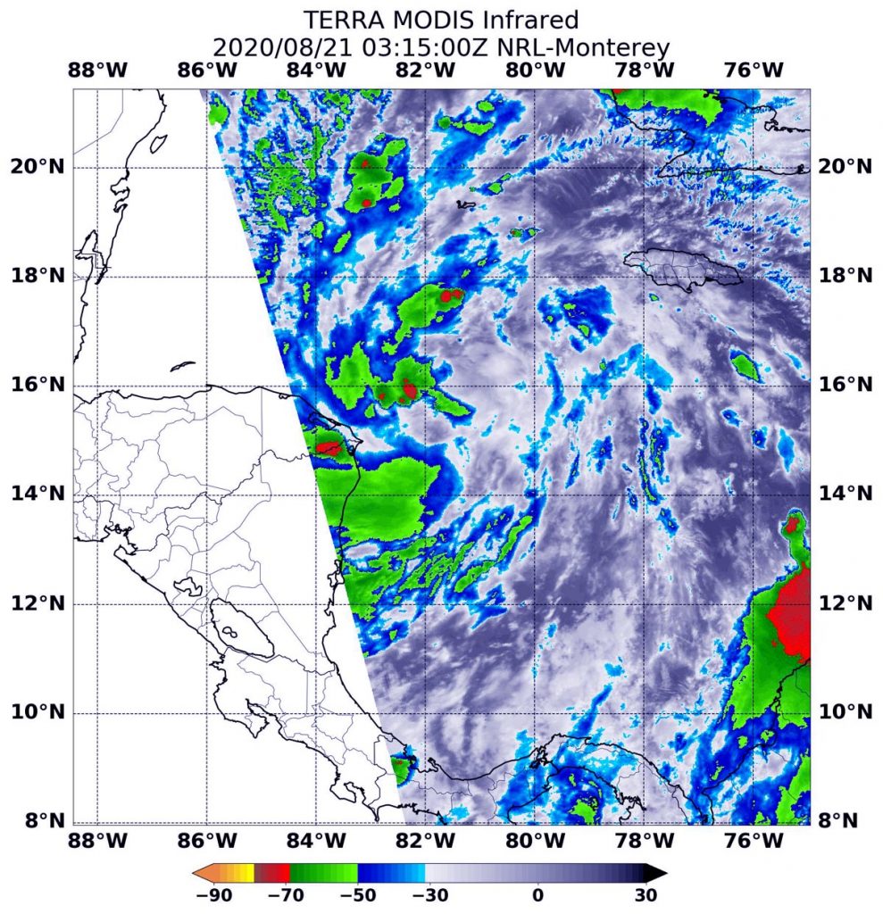
On Aug. 21 at 0315 UTC (Aug. 20 at 11:15 p.m. EDT), the MODIS instrument that flies aboard NASA’s Terra satellite gathered infrared data on TD14 that showed the strongest storms (yellow) had the coldest cloud top temperatures as cold as minus 60 degrees Fahrenheit (minus 51.1 Celsius). Credit: NASA/NRL

NASA’s Terra satellite uses infrared light to analyze the strength of storms by providing temperature information about the system’s clouds. The strongest thunderstorms that reach high into the atmosphere have the coldest cloud top temperatures.

On Aug. 21 at 0315 UTC (Aug. 20 at 11:15 p.m. EDT), the Moderate Resolution Imaging Spectroradiometer or MODIS instrument that flies aboard NASA’s Terra satellite gathered infrared data from the depression that found the coldest cloud top temperatures were as cold as or colder than minus 60 degrees Fahrenheit (minus 51.1 Celsius). The strongest storms were mostly on the western side of the storm. However, a fragmented band of thunderstorms extending to the southeast also contained strong storms. NASA research has found that cloud top temperatures that cold can generate heavy rainfall. Some of that heavy rain was affecting Mexico’s Yucatan Peninsula.

Several watches and warnings were in effect today, Aug. 21. A Hurricane Watch is in effect from Punta Herrero to Cancun, Mexico. A Tropical Storm Warning is in effect for the Bay Islands of Honduras and from Punta Herrero to Cancun, Mexico. A Tropical Storm Watch is in effect for north and west of Cancun to Dzilam, Mexico.

At 11 a.m. EDT (1500 UTC), the National Hurricane Center noted that the center of Tropical Depression Fourteen (TD14) was located near latitude 16.6 degrees north and longitude 84.1 degrees west. That is about 165 miles (270 km) east of Roatan, Honduras and about 325 miles (525 km) southeast of Cozumel, Mexico.

The depression is moving toward the northwest near 14 mph (22 kph). A slower northwestward motion is expected over the next couple of days, followed by an increase in speed by Sunday and Monday. Maximum sustained winds are near 35 mph (55 kph) with higher gusts.

NHC said, “Strengthening is forecast during the next couple of days, and the depression is expected to become a tropical storm later today.  The system is forecast to be near or at hurricane strength when it reaches the Yucatan Peninsula of Mexico late Saturday.  Some weakening is expected as it moves over the Yucatan Peninsula Saturday night.  Afterward, restrengthening is forecast on Sunday as it moves offshore and enters the southern Gulf of Mexico.

On the forecast track, the center of the depression will move away from the coast of Honduras today and will approach the east coast of the Yucatan Peninsula of Mexico on Saturday.  The center will then cross the northeastern part of the Yucatan Peninsula Saturday night and move over the central Gulf of Mexico toward the northwestern Gulf on Sunday and Monday.”

NASA Researches Tropical Cyclones

Hurricanes/tropical cyclones are the most powerful weather events on Earth. NASA’s expertise in space and scientific exploration contributes to essential services provided to the American people by other federal agencies, such as hurricane weather forecasting.

For more than five decades, NASA has used the vantage point of space to understand and explore our home planet, improve lives and safeguard our future. NASA brings together technology, science, and unique global Earth observations to provide societal benefits and strengthen our nation. Advancing knowledge of our home planet contributes directly to America’s leadership in space and scientific exploration.

For updated forecasts. visit: www.nhc.noaa.gov
By Rob Gutro
NASA’s Goddard Space Flight Center