IceBridge Field Work – A Project Manager's Perspective

By Christy Hansen, IceBridge Project Manager, NASA Goddard Space Flight Center

Field work in the Arctic is a unique and challenging experience. It takes an experienced and tough team to complete mission objectives from start to finish despite the biting cold, long days and noisy environment. Early morning temperatures are often in the negative single digits, and the IceBridge team powers through it preparing for flight each day. A typical day’s work can range 12 to 14 hours, a schedule that is repeated daily until the airport is closed or until the flight crew reaches a required hard down day.

My project management perspective allows me to take a step back and appreciate not only the technical expertise of our instrument and flight crew teams, but the masterful choreography that unwinds each day to ensure the P-3B aircraft is prepped and ready, the instruments are powered on and in working condition, and the weather and corresponding science flight plan has been assessed and defined. Being actively involved in all phases of Operation IceBridge makes for a stronger and well-versed leader better able to assist any part of the team at any time. By doing this, I can ensure we are on track to meet our mission and science requirements, assist with troubleshooting in and out of the field, better manage project milestones, and ensure streamlined communication across all IceBridge disciplines with a common goal.

IceBridge project manager Christy Hansen on the stairway to NASA's P-3B.
IceBridge project manager Christy Hansen on the stairway to NASA’s P-3B. Credit: NASA / Christy Hansen
But why do we do this? How do we do this? 

We do all of this in the name of science, collecting polar geophysical data that will help characterize the health of the Arctic and Antarctic. The in-field data and derived data products IceBridge produces are helping to show annual changes in the ice. These data can be entered into models that can more accurately predict what might happen in the future in terms of ice sheet, glacier, and sea ice dynamics, and ultimately sea level rise; all of which have serious consequences for climate change.

But how do we reach these science goals? The steps and teamwork required are simply astounding. Each part of our team is like a puzzle piece and everyone is needed to complete the puzzle. All teams must clearly know their individual responsibilities, but also be able to work together and mesh where their job ends and another begins.

The choreography starts in the beginning, or planning phase where the science team establishes targets of interest on the ice in accordance with our level 1 science requirements. Then our flight planner designs survey flights, having a unique ability to efficiently mesh the science targets with the range and flight dynamic capabilities of the P-3B aircraft.

Next the aircraft office at NASA’s Wallop’s Flight Facility prepares the P-3B for deployment to some of the harshest environments on Earth and supplies the flight crew that executes the specific flight paths over our required science targets. The instrument teams provide the instrumentation—laser altimeters, radars, cameras and a gravimeter and magnetometer—and expertise in operating equipment and processing data during and after flights. Our logistics team deploys to the field ahead of time, establishing security clearances, local transportation and accommodations, and internet and airport utilities.

Finally, our data center ingests and stores the data that our team collects, ensuring it’s useable and available to the wider community. Our data is not only used by polar scientists and other researchers around the world, it is also used to help satellite missions like the European Space Agency’s CryoSat-2 and NASA’s ICESat-2 calibrate and validate satellite instrumentation.

A view of ice from NASA's P-3B airborne laboratory.

A view of ice from NASA’s P-3B airborne laboratory. Credit: NASA / Christy Hansen

And finally, a day in the field …

Assuming a standard 8 a.m. local takeoff and eight hour mission duration, we generally have three major groups who follow different schedules pre-flight each morning.

The P-3 maintenance and flight engineer crew typically starts the earliest, heading to the airport about three hours before takeoff. They prep and warm up the plane, conduct some tests and fuel it, all in preparation for the instrument team arrivals and flight operations.

In parallel with aircraft prep, IceBridge’s project scientist, project manager and flight planner team head to the weather office. The team works with local meteorologists, reviewing satellite imagery and weather models to determine the optimal weather patterns that support our flight requirements—clear below 1500 feet, the altitude we typically fly—and final target selection.

In the meantime, the instrument teams arrive at the aircraft to power up and check their systems prior to takeoff. By 7:30 a.m., the aircraft doors close, and we take off by 8. Our eight-hour flights range between flying high and fast, to low and slow over our targets, which include geophysical scans of ice sheets, glaciers, and sea ice.

We typically land around 4 p.m., close out the plane, check data and meet at 5:30 for a science meeting. Many folks continue to work for a few hours afterward, processing data or writing mission reports. All of this is repeated daily, for up to 6 days in a row, which can be exhausting, but in the name of important scientific research, an amazing team, and majestic polar landscapes, I could not imagine anything else.


Crew members working on the P-3B. Credit: NASA / Christy Hansen

Weather and Operation IceBridge

By John Sonntag, OIB Instrument Team Lead, NASA

If you know the saying “make hay while the sun shines”, you’ve already got a pretty good idea of how weather affects flight operations for Operation IceBridge. Generally speaking, our flights require clear skies over the area in which we are operating on any given day. There are two good reasons for this. First, some of our sensors, including the Airborne Topographic Mapper and the Digital Mapping System, are optical instruments and need the sky between the aircraft and the ground to be cloud-free to obtain their measurements. Second, since we usually fly low and close to terrain (and sometimes amongst mountain peaks), our pilots need clear skies in order to see and avoid the terrain for flight safety reasons. These requirements mean that weather largely governs what we do on any given day, and makes it necessary for OIB project scientist Michael Studinger and myself to remain immersed in the minutiae of polar weather every day while we are in the field. On every potential flight day, we must make a decision about whether to fly and where to fly, and if we make the wrong decision we might face the mortifying prospect of returning from an expensive taxpayer-funded flight without science data to show for it. So far in the 3-year history of OIB, that has not happened, and Michael and I very much want to maintain that record.

Michael and I typically start studying the current weather patterns governing our operating areas at least a week prior to our deployment. It is helpful to develop a sense of context and a feeling for the current weather systems and their movements before we must begin making decisions on flight days. Our primary tools for this, and for all of our weather analysis tasks, are satellite imagery in several wavelengths, meteorological forecast models and point observations of current weather conditions from observers on the ground.

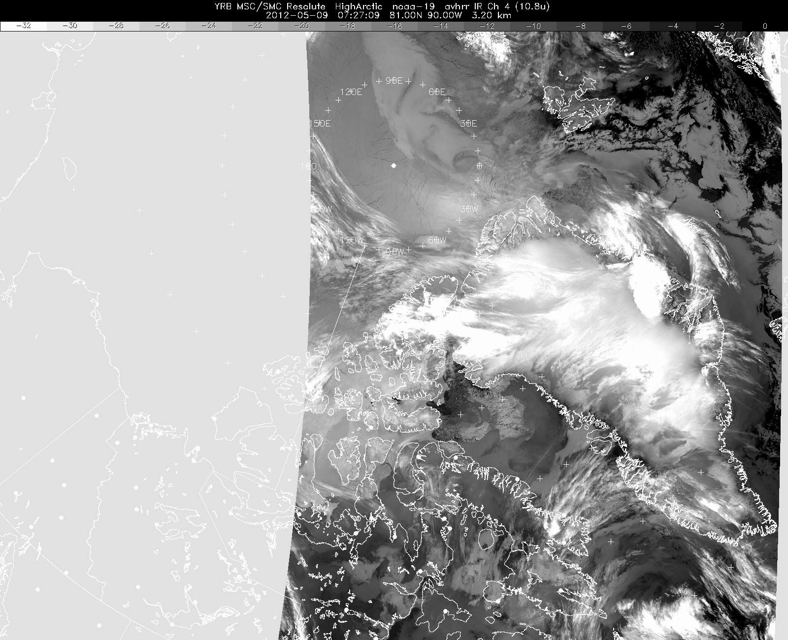
An early morning weather satellite image of Greenland and Arctic Canada, taken on 9 May 2012.

An early morning weather satellite image of Greenland and Arctic Canada, taken on 9 May 2012. This image is an infrared image from a NOAA polar orbiter, and while it shows significant cloud cover at several altitudes over western Greenland, we chose to fly a mission along a narrow corridor along the northwest coast of Greenland where the weather was clear. Credit: NOAA

Satellite imagery, most of which is provided by NOAA polar-orbiting satellites in our case, gives us a snapshot of the clouds over an area of interest. Imagery in the infrared band shows us not only the extent of the clouds over an area but also suggests the altitude of the cloud tops, since the infrared band is sensitive to temperature, and cloud temperatures are dependent on their altitude. Basically, bright white clouds are high, gray clouds are medium or low, and ground fog can sometimes be almost indistinguishable from the ice surface as their temperatures are similar. Visible imagery is better at showing us texture, which helps us distinguish between ice surface and fog, estimate the thickness and density of the cloud cover and determine the distance between cloud bases and the terrain beneath by virtue of the shadow they cast on the surface, especially when the sun angle is low. Another type of imagery we sometimes use is known as the “3 micron” band for its wavelength. This type is particularly sensitive to the amount of water vapor present in cloud masses.

We often refer to ground observations to help us refine our interpretation of satellite imagery, primarily because they provide a reliable measurement of the distance between the ground and the cloud bases. Sometimes the clouds are high enough and the terrain sufficiently benign that we are able to fly below the cloud bases, and point observations occasionally allow us to make such a judgment with some confidence we might not otherwise have. We must be careful, however, to remember that these observations are valid at one point only, while our flights cover large distances.

But for forecasting weather into the future, we are highly dependent on computer meteorological models, which predict what the weather may be like later in a day, or into the next day or beyond. Such information is critical for planning and optimizing our flight selections. For example, we might examine satellite imagery early on a potential flight morning and conclude the weather over our target is clear, but if a forecast model shows that the weather there will deteriorate by mid-day we would probably choose not to fly there. Sometimes the reverse occurs, where morning imagery might show marginal conditions over a target area but the forecast models confidently predict quick improvement. In such a case we might choose to launch a flight into the area, if our confidence in the model predictions is sufficient.

A typical flight day for me (and probably Michael as well) literally starts with weather as soon as I roll out of bed. The first thing I do every morning, even before brushing my teeth, is to open up my laptop and download a few satellite images to get a sense of cloud cover. That way I can mull it over while I get showered and into my flight suit and have breakfast. After breakfast, Michael and I, and our pilots, head to the local airport’s weather office to get their take on the weather where we are going. I cannot stress enough the importance we place on our discussions with these professional meteorologists, nor can I praise them enough for the help they invariably give us. Most of them seem to genuinely enjoy the professional challenge we bring to them, since the kind of flying we do, and the weather we are dependent on, are so different from those of the flight crews they normally deal with. In this morning weather briefing, we go over everything they have available, including satellite imagery, model predictions, point observations, and their own professional and experientially-derived “feel” for the conditions. Once we have gathered all the information available, it is decision time. We always remember that when we launch a flight, we are committing the U.S. taxpayer to pay many thousands of dollars to operate a big, expensive aircraft that day. So we take this decision very seriously, and at times it can be a rather nerve-wracking process.

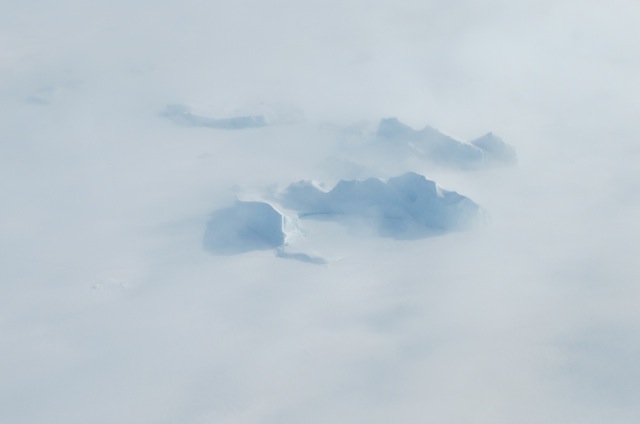
Icebergs in a northwest Greenland fjord shrouded in fog.

Icebergs in a northwest Greenland fjord shrouded in fog. Credit: NASA/Jim Yungel.

Once in the air we constantly monitor the weather to see if it was as we expected, based on the morning weather briefing. It usually is, though the exact locations of cloud boundaries and ceilings are sometimes slightly different from what was predicted, and occasionally ground fog might exist where we did not expect it. We find that ground fog is consistently the most difficult aspect of polar weather to predict, although it has never adversely affected a flight to a serious degree. We also monitor the winds and compare these to the forecasts, which is important because winds can create turbulence under certain conditions, and turbulence can create a variety of problems for us.

Once we land, Michael and I immediately head back to weather office to get a forecast for the next day. Next, based on what I heard at this post-flight briefing and on further information I obtain from the internet, I prepare a weather briefing for the entire field team, which I give at our nightly science meeting. This briefing usually has two parts. First is a quick retrospective analysis of the day’s mission, comparing the weather we expected with what we actually encountered. Doing this on a daily basis helps us fine-tune our understanding of the performance of various weather models, our interpretation of imagery and our general decision-making process. Next I give an overview of our expectation of the next day’s weather and which flights might be best-suited for it. This enables the flight crew and the instrument operators to prepare for the next day’s activities.

The next morning, the process starts all over again. By the time we end a long deployment (the current one will be 11 weeks long), I look forward to spending entire days without looking at a weather image. But to be honest, I am at heart a weather geek, and after being back home for a while I miss the sense of connectedness I had to the natural world from remaining so immersed in meteorology for such a long time.

I have found that the key to successful weather-based decision-making is to consult as wide a variety of sources as possible, diligently calibrate oneself to the strengths and shortcomings of all weather models and other sources of data, and probably most importantly, simply stay on top of the weather situation multiple times each day. By doing this we can develop an almost intuitive sense for the evolving weather regime, which helps us quickly digest new information and interpret it correctly. Finally, I think it’s important to cultivate a sense of humility with regards to weather forecasting. Meteorology is a complex business and there is much we do not know. This is particularly true in the polar regions, because in contrast to places such as the continental US, the measurements that feed weather prediction tools are extremely sparse. In practice this sense of humility translates into keeping an open mind about the weather, avoiding coming to hasty conclusions before consulting every possible source and having contingency plans ready in case things do not work out exactly as we thought.