Calibrating in California

Before the IceBridge crew flew to Thule, Greenland, they performed a test flight on March 17 in California to calibrate the aircraft’s science instruments.


From: John Sonntag, senior scientist with the IceBridge management team, URS Corporation in Wallops Island, Va.

This Google Earth image graphically illustrates one of the many techniques the Airborne Topographic Mapper (ATM) team utilizes to calibrate and validate our instrument.

The image shows El Mirage Dry Lake, about 25 miles east of Palmdale, Calif. We overflew the lakebed three times on the March 17 test flight — the flight paths are shown in green. The extremely detailed elevation measurements made by the ATM are depicted by the multi-colored swath, with warm colors depicting topographic “highs” and cool colors depicting lows. The red path is a survey we conducted of the lake surface with a GPS-equipped vehicle.

By comparing the ATM laser swath measurements with the surface measurements we made using the GPS-equipped vehicle, we can derive a variety of calibration measurements for the ATM, which we use to improve its accuracy and precision, ultimately to the level of a few centimeters. This process has just begun and will be supplemented by many other datasets as we proceed with the campaign.

Another aspect this image illustrates is the extremely high precision of our navigation systems, which are also part of the ATM system. The flight crew “coupled” their autopilot to our precise navigation system for all three of these passes. The result was that all three passes were within just a few meters of each other — pretty impressive when we’re flying at 250 knots!

NASA Readies for Spring 2010 Ice Bridge Campaign

From: Kathryn Hansen, Science Writer, NASA’s Earth Science News Team


Credit: John Sonntag/Wallops Flight Facility

In August 2008, NASA scientist John Sonntag, of NASA’s Wallops Flight Facility in Wallops Island, Va., captured this view of a small iceberg as it moved down the Narsarsuaq fjord in southern Greenland. “I spent about half an hour watching that little berg, which was in the process of disintegrating during the time I was watching,” Sonntag said. “It went from a complete, small berg to a collection of floating ice rubble within that small span of time. The place was so quiet that the noise of the berg softly coming apart was the only sound present.”

Sonntag’s observation took place during the 2008 NASA and Center for Remote Sensing of Ice Sheets (CReSIS) airborne deployment in Greenland. This spring, Sonntag and other scientists return to the Arctic for big picture and little picture views of the ice as part of NASA’s six-year Operation Ice Bridge mission — the largest airborne survey of Earth’s polar ice ever flown — now entering its second year. The project team is finalizing flight paths over Greenland’s ice sheet and surrounding sea ice, where scientists will collect measurements, maps and images from a suite of airborne instruments. Such information will help scientists extend the record of changes to the ice previously observed by NASA’s Ice, Cloud, and land Elevation Satellite (ICESat), while uncovering new details about land-water-ice dynamics.

NASA aircraft have made numerous science flights over Greenland, most recently during the spring 2009 Ice Bridge campaign and also in 2008 as part of the NASA/CReSIS deployment. Smaller-scale airborne surveys have been made by William Krabill, of NASA Wallops, and colleagues nearly every spring since 1991.

Visit the Operation Ice Bridge Web page throughout the spring 2010 campaign for news, images, and updates from the field. Flights from Greenland are scheduled to begin no sooner than March 22.


Welcome to the Start of the Operation IceBridge 2010 Campaign


From: Lora Koenig, IceBridge project scientist, NASA’s Goddard Space Flight Center


Credit: Image is courtesy of Lora Koenig, NASA’s Goddard Space flight Center

Hello, and welcome to the start of the Operation IceBridge Greenland 2010 campaign. Over the next few months we will be blogging about the science, research, aircraft, and day to day activities of our airborne campaign. The NASA DC-8 aircraft is fully loaded in Palmdale, Calif., and will take off late Sunday night to fly scientists, crew and instruments to Thule, Greenland. The DC-8 will stay in Greenland until the end of April at which time the NASA P-3B aircraft will take over for another month of flights monitoring the changes occurring over the Greenland ice sheet and the Arctic sea ice. Hopefully some of you are returning to the blog after our previous Greenland 2009 and Antarctic 2009 campaigns. Please check in often to follow our progress and learn more about our exciting Arctic research.

My name is Lora Koenig and I am a physical scientist in the Cryospheric Sciences Branch at NASA’s Goddard Space Flight center. You may be asking, what is cryospheric science? Well, it is the branch of science that studies the areas of frozen water on Earth. This includes science related to snow, sea ice, ice sheets, glaciers and permafrost. My research is focused on monitoring changes over the Greenland and Antarctic Ice Sheets and for the last five months I have been one of the NASA project scientists in charge of IceBridge. In this blog I will tell you a little about the planning that has gone on behind the scenes for this campaign.

For the last five months, starting while most of the IceBridge team was still in Antarctica, NASA started planning for the Greenland 2010 Campaign. Because the austral (Southern Hemisphere) spring and boreal (Northern Hemisphere) spring are only six months apart the IceBridge team is constantly planning for the next field campaign. Yes, the Antarctic 2010 campaign planning has already started and the DC-8 has yet to take off for Greenland.

What does planning for a major NASA airborne mission entail? Two things: logistics and flight line planning. A team at NASA’s Earth Science Project Office (ESPO) and the aircraft crews have been busily working to ensure that the instruments are ready to be loaded on the plane, flight clearances are in place, hangers are ready and sufficient for the planes to use, hotel reservations are made, airports are open, divert airports are nearby in case of bad weather, cargo is shipped, the science and instruments teams have flight reservations and passports, cold weather gear is assembled, food is available, internet is set up, and the list goes on and on. These behind the scenes logistics and preparation make for a successful field campaign.

While ESPO was dealing with the logistics, the IceBridge science team and I were tasked with planning flight lines. The Greenland ice sheet and the Arctic Ocean are large areas to monitor. Our aircraft cannot fly everywhere so the science community works together to decide where to fly, when to fly, and how often to fly. Flight decisions are made though a consensus process conducted by teleconferences and meetings with groups of scientists who specialize in studying sea ice, the Greenland ice sheet and ice sheet modeling. Most of the scientists are trying to answer one of the following questions: How are changes in the Greenland ice sheet affecting sea level rise? What changes are occurring to the Arctic sea ice extent and thickness? And in the future, what changes should we be preparing for as the Greenland ice sheet and Arctic sea ice cover change?

Each community of scientists requests specific areas where they want data, and each community desires a specific instrument to take their measurements. In many cases there is overlap in flight lines and instruments and in some cases there is not. Throughout this campaign you will hear about specific flights and the scientific reasons they were flown. Some flights will focus on sea ice, others will overfly glaciers that are changing rapidly and some will overfly scientist working on the ground so results can be extrapolated over a larger area. The IceBridge flight plans are designed to meet the needs of many within a limited amount of time. Flight line planning started in January and was just completed last week. John Sonntag, who you are sure to meet later in the campaign, is the master flight line designer and keeps the aircraft on track for making important scientific discoveries.

Well, I hope this gives you a bit of a flavor for the work that has been occurring by computer, phone and desk to get the Greenland 2010 Campaign up and flying. Next stop Thule, Greenland, with a transit flight that — weather dependant — was designed to monitor a small portion of the southeast Alaskan glaciers and the Arctic sea ice on a transect across the Arctic Ocean.

First Flight: Across the Getz Ice Shelf


From: Steve Cole, Public Affairs Specialist, NASA Headquarters


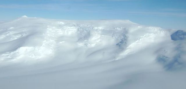
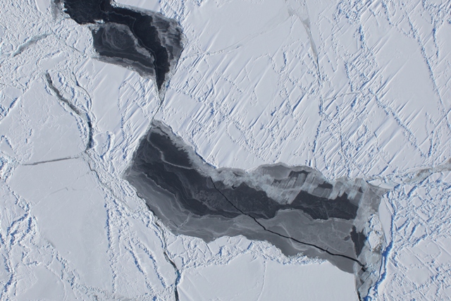
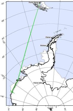
PUNTA ARENAS, CHILE – The first flight of Operation Ice Bridge was made from the southern tip of South America on Friday, Oct. 16. The primary target was the Getz Ice Shelf along Antarctica’s Amundsen Coast. The DC-8 flew two parallel tracks along the coast, one just offshore over the floating ice shelf, and one just inland. By measuring on either side of the “grounding line” between the floating ice and the ice on land, scientists can determine the rate at which this near-shore part of the ice shelf is melting.


This target area was selected from the series of flights planned because weather forecasts showed that this was the only clear area available. The low-altitude Getz grounding line paths would allow for a survey of the bottom topography with the MCoRDS instrument, a search for the presence of under-ice water with the gravimeter, and ice surface topography measurements with the ATM laser instrument.


The plane took off at 9:11 a.m. local time with 31 people onboard, including a videographer with the Associated Press. The DC-8 flew at 35,000 feet on the ocean transit to Getz. During this part of the flight, the LVIS laser and the DMS mapping camera made observations of the sea ice. The DC-8 covered 1630 nautical miles before getting to its science targets in Antarctica.


The DC-8 descended to about 1500 feet just east of the Scott Peninsula to begin the low-altitude observations. At the end of the flight path over the Getz Ice Shelf, the plane turned out over the sea ice, which was characterized by open water.


The DC-8 then flew up the DeVicq Glacier to an elevation of about 5,000 feet. Returning to the onshore survey line, the pilots were able to fly the entire line with clear skies. We completed a total of 3.5 hours of low-level flight. The ATM team reported collecting about 200 million laser measurements during the flight. The DC-8 landed at about 9 pm.  Total flight time: 11 hours, 45 minutes.


— Based on reports from Seelye Martin (University of Washington) and James Yungel (NASA Wallops Flight Facility)


Getz Ice Shelf at low altitude (Photo courtesy Seelye Martin)


Mount Kauffman at the head of the DeViqc glacier (Photo courtesy John Yungel)


Antarctic sea ice from 20,000 feet. (Photo courtesy John Arvesen)


The Return of a Chilean Native


From: Jill Hummels, Public Information Officer, University of Kansas School of Engineering

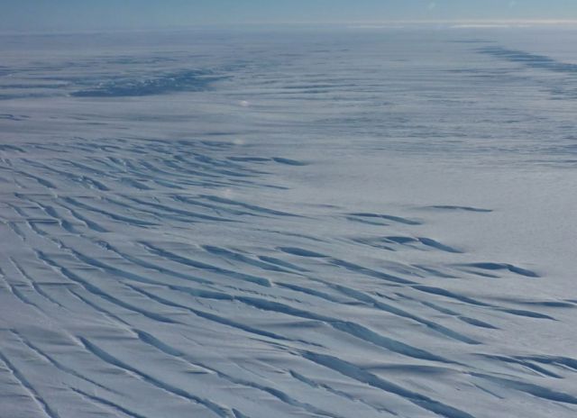
The far tip of Chile is no stranger to one member of the Operation Ice Bridge team.  It’s almost home.

Victor Jara Olivares – an electrical engineering doctoral student, graduate research assistant and native of Concepción, Chile – is among the University of Kansas team members who’ll be in Punta Arenas for the NASAs mission.


Jara has been involved in making improvements to the MCoRDS radar and supporting additional radars KU is supplying for the mission. He’s also been integral to the development of another radar to be used by in Antarctica later this season for a National Science Foundation Center for Remote Sensing of Ice Sheets (CReSIS) mission.


As an officer in the Chilean Navy, Jara was involved with the Center for Scientific Studies of the South of Chile and has been to Punta Arenas before.  In 2002, while managing a naval air base, Jara helped NASA secure the use of a P3 aircraft.


That exchange put him in touch with Prasad Gogineni, distinguished professor at KU and director of CReSIS, and fostered his interest in remote sensing and polar studies. Freshly armed with master’s degrees in both aerospace engineering and electrical engineering, he was encouraged to pursue a doctorate and was offered a GRA position at KU. It didn’t hurt that his fiancée (now his wife) also was from Kansas.


Jara excitedly shares travel tips and insight to his native culture with anyone who’ll listen.  He offers three “musts” for any leisure traveler to Chile:


• Drink a pisco sour

• Eat a local empanada

• Visit Laguna San Rafael


During Ice Bridge, Jara plans to focus on radar work and forego any family visits. Chile, he points out, is as long as the United States is wide, and the 1,600 hundred-mile drive from Punta Arenas to visit his parents would take days.


Inside the DC-8: Instrument Test Flight


From: Nick Frearson, Gravimeter Instrument Team, Lamont-Doherty Earth Observatory


The flight engineer ticks off instruments over the intercom. “LVIS, ready.” “Gravity, ready.” “DACOM, ready.”


We are about to take the DC-8 on its first test flight before Antarctica. The pilots, clipped and professional, have just described the day’s flight plans and the plane is bustling with people making last-minute adjustments.


Suddenly we are ready to go. The city of Palmdale, Calif., drops away as the plane climbs and circles. The dried up lake bed that is home to Dryden and Edwards Air Force Base spreads out below, giving us a Google-Earth view of the area.


We head west over the hills and Los Angeles, indistinct through the haze, and out over the Pacific Ocean. The gravimeter in front of me and Stefan purrs quietly. The aim of the flight is to test and calibrate the laser altimeter – the Laser Vegetation Imaging Sensor (LVIS) – which will measure the surface elevation of the ice sheet.


At 28,000 feet we perform a series of maneuvers to sweep the laser beam back and forth beneath the aircraft. The LVIS engineer is talking to the flight engineer over the intercom while he aligns the instrument. I can hear static, whistles and pops over their voices but nothing that appears to be interfering with our instruments.


To my left an instrument samples the air as we fly along. Melissa, who built the equipment a few days ago, watches pressure gauges and tweaks the dials. Outside, I can see Catalina Island surrounded by clear water. The LVIS engineer announces that he is happy with the laser so we turn for home.


We pass over the smog of L.A., mountains still scarred from the recent forest fires, and the Mojave Desert, where the clear air allows you to see for miles. Back on the ground we head for flight debrief.


Sean downloads the gravity and GPS data that will tell us how well the gravimeter performed. First indications are looking good.


Snapshots: Final Preparations


Ice Bridge science team members at the NASA Dryden flight operations facility in Palmdale, Calif., took these photos of their final preparations in the days before departing for Chile. – Steve Cole, NASA Public Affairs


The Gravity Team from the Lamont-Doherty Earth Observatory of Columbia University on Sunday, Oct. 11 catching the last sun rays outside the NASA hangar a few hours before departing on the DC-8 for Chile. From left: Stefan Elieff (Sander Geophysics), Michael Studinger (Lamont-Doherty), Nick Frearson (Lamont-Doherty), Sean O’Rourke (Sander Geophysics). Photo by Michael Studinger.


Scientists checking their equipment inside the DC-8 before last week’s final science test flight at Dryden. Photo by Nick Frearson (Lamont-Doherty).


University of Kansas graduate student Lei Shi tests the Multichannel Coherent Radar Depth Sounder (MCoRDS) VHF-band radar system in loopback mode during the transit portion of a recent system check flight. Photo courtesy Chris Allen (Univ of Kansas)


Getting You Behind the Scenes


From: Steve Cole, Public Affairs Specialist, NASA Headquarters, Washington, D.C.


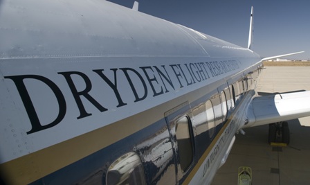
The last time I was on NASA’s big DC-8 “flying laboratory,” I never got off the ground.


It was a bright April day last year in Fairbanks, Alaska. There was fresh snow on the runway and a wind chill of about 0 degrees Fahrenheit. I was helping journalists get behind the scenes of NASA’s airborne campaign to see how air pollution factored into climate changes across the Arctic. The DC-8 was filled with scientists and instruments and reporters – Associated Press, National Public Radio, the Fairbanks Daily News-Miner – on our media tour of the plane at the city’s airport. (In the photo, I’m the helpful one on the right.)


That’s what we do in NASA’s Office of Public Affairs: help get the word out to the press and public about the cutting-edge science, technology, and exploration that U.S. taxpayers sponsor through our civilian space agency. My slice of NASA is the Earth Sciences Division. Although I usually work this beat from behind a desk, once in a while I get to head outside when NASA launches a new Earth-observation spacecraft or takes to the field to do some science.


Now I’m no scientist (English major, thank you), but I’ve been writing about what scientists do for over 20 years. What fascinates me about the whole endeavor is the ingenious ways these men and women find to see things that haven’t been seen before. Who has seen a continent-sized ice sheet change before? I mean, how do you do that? Well, they find a way.  It’s an amazing and fun thing to watch.


And with Operation Ice Bridge, I might finally be able to watch scientists doing their work from the air. The DC-8 flight managers tell me there should be enough spare seats for reporters and public affairs types like me to fly along over Antarctica. If that works out, I’ll be sharing the experience with you using the new media tools we now have available: Twitter, YouTube, Flickr, and this blog.


Look for my live reports from Punta Arenas, Chile, starting Oct. 16.


Flying the Antarctic: The Trouble with Weather


From: Seelye Martin, Chief Scientist, Operation Ice Bridge


The issue of forecasting weather conditions over Antarctica presents a serious challenge to the Operation Ice Bridge DC-8 flights that get underway in just two weeks.

In the Southern Hemisphere, the Antarctic Ocean is unique in that the Antarctic Peninsula (the focus of many of our flights) is the only north-south oriented land barrier. Within this region, five or six weather systems accompanied by clouds and strong winds, rotate rapidly around the continent from west to east. The clouds from these systems extend from the ocean to the ice sheet, and are associated with strong winds. These systems are partially blocked by the mountains on the Peninsula that rise to approximately 10,000 feet (3,000 meters). Between these weather systems, periods of clear sky occur.

(See for yourself. Here is a link to one Antarctic forecast tool I’ve been using: http://www.mmm.ucar.edu/rt/wrf/amps.  After opening the first page, click on “animations” at the top left; in the next frame select “cloud base” under the first pull-down menu on the left. The image above is a sample of what you’ll see.)

The challenge in planning the flights is that we require clear weather over the target area to operate the lasers. For aircraft safety, we also need to avoid severe storms.


We will obtain our forecasts by working with the Chilean weather service, with polar scientists from the Centro de Estudios Cientificos (Center for Scientific Studies), by examination of satellite imagery downloaded at the airfield, and by use of web-based forecasts.


Another mission challenge is that as it proceeds, our ability to obtain a cloud-free flight decreases. This occurs because at the beginning of the flight series, we have a variety of geographically dispersed targets, such as the sea ice in the Weddell and Amundsen seas, the Peninsula glaciers, and the ice sheet in the vicinity of Pine Island and Thwaites glaciers. This gives us geographic flexibility and the ability to choose a cloud-free region from many different sites. As the flights proceed, the number of our target sites decrease, and finding cloud-free conditions over the target will become more difficult.


A New Way to Experience Antarctica


From: Michael Studinger, Instrument Co-Principal Investigator, Lamont-Doherty Earth Observatory 


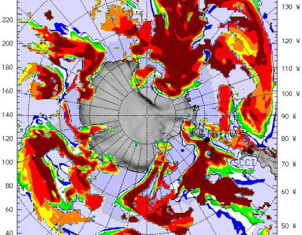
The scale and style of Operation Ice Bridge will be a new experience for me. I’ve been involved in airborne research for more than a decade using ice-penetrating radar systems, airborne laser scanning, gravity and magnetics to learn more about the polar ice caps and how they behave.


In previous airborne campaigns we have used small instrumented Twin Otter aircraft and operated out of remote field camps deep in the interior of Antarctica and at high elevations and extreme temperatures. This means living and working in tents for months at temperatures around -20 to -40°F and flying in unpressurized aircraft at high altitude. There are no showers and only limited communications with the outside world in these remote field camps.


The Ice Bridge campaign will be very different from that. We’ll be flying non-stop roundtrips on the large NASA DC-8 from Punta Arenas, Chile. It feels a bit strange to be flying over Antarctica without actually setting foot on the continent and experiencing firsthand the icy cold and breathtaking beauty of the polar landscape. During Ice Bridge we will have to enjoy the fascination of the polar environment from a heated and pressurized aircraft cabin.


I am a research scientist at Columbia University’s Lamont-Doherty Earth Observatory in New York. My background is airborne geophysics which I use to study the ice caps and the Earth’s crust in polar regions. For Ice Bridge, I’ll be involved in measuring the Earth’s gravity field to estimate how deep the water is beneath floating glaciers along the Antarctic Peninsula.


I’m looking forward to a relaxed airborne campaign, where you leave from Punta Arenas in the morning and return to civilization in the evening.