From: Kathryn Hansen, NASA Earth Science News Team / Cryosphere Outreach
April 3, 2011

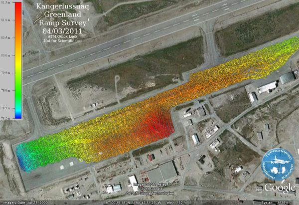
Colors show elevation differences across the airport’s ramp in Kangerlussuaq, Greenland. The map is used to calibrate airborne instruments. Credit: NASA/ATM team
Kangerlussuaq, Greenland — During the last IceBridge campaign, based in Punta Areans, Chile, we described a three-hour ramp survey. Scientists drove a truck with a GPS antenna affixed to the roof to map the precise elevation of the airport’s entire ramp — the pavement next to the runway where the aircraft spends each night. The ramp map helps researchers calibrate science instruments on the aircraft.
Here in Greenland, at Kangerlussuaq International Airport, the same activity on Saturday, March 3, would turn into a five-hour survey.
“This has to be the biggest ramp in the world,” said Kyle Krabill who drove the car, bringing me along as the unsuspecting passenger.
The task started that morning after idling for an hour on the ramp to calibrate the GPS. Then, we rolled off at a whopping 15 miles per hour, windows rolled down and 80’s Danish music blaring. Back … and forth … and back … and forth … we traced around the perimeter of the ramp and then inward, as if we were mowing a lawn of pavement.
A time lapse shows one hour of four-hour-long ramp survey. Video credit: NASA/Jefferson Beck
“See how easy it is to be a scientist?” Krabill joked. But it turns out that driving the car is just the beginning.
Krabill is part of the team that runs the Airborne Topographic Mapper (ATM), an instrument flying with IceBridge. ATM pulses laser light in circular scans on the ground. The pulses reflect back to the aircraft and are converted into elevation maps of the ice surface.
Toward the end of each flight, ATM laser elevation data are also collected during a pass over the ramp. Putting the data all together (including the dizzying ground-based ramp survey), and knowing the precise location of the aircraft (via a technique called “differential GPS”) scientists can decipher and eliminate some of the inherent error that comes with flying a laser scanner, such as errors in range — the physical distance to the ground — and in the team’s knowledge of the way in which the scanner is mounted in the aircraft.
“Differential GPS is fundamental to what we do,” said John Sonntag, ATM senior scientist. “It’s tremendously powerful, taking position error down from about 10 meters to 10 centimeters or better — a huge improvement.”
