Media Day in Chile

From: Kathryn Hansen, NASA’s Earth Science News Team, NASA’s Goddard Space Flight Center

Video conference between IceBridge scientists in Punta Arenas, Chile, and reporters in Santiago. Credit: NASA/Sarah DeWitt

PUNTA ARENAS, Chile — In a perfect world, IceBridge researchers would make science flights over Antarctica almost every day and return home with a check next to every high-priority science flight. The 2009 campaign — the first year IceBridge made flights over Antarctica — was just about perfect. But that’s a rarity in Antarctic research where whether and unanticipated aircraft maintenance can ground flights.

During days on the ground, however, researchers keep busy. On Monday, Nov. 15, IceBridge scientists gathered at Universidad de Magallanes in Punta Arenas, Chile, to answer questions from local reporters and from reporters in Santiago via live video feed (video below).


Video credit: NASA/Michelle Williams

Missed it? Get a replay of the teleconference until Nov. 29 by calling:

Phone: Tfree:800-469-6597

Toll:203-369-3288

Rollercoaster of Opportunity

From Kathryn Hansen, NASA’s Earth Science News Team, Goddard Space Flight Center

Nov. 13, 2010

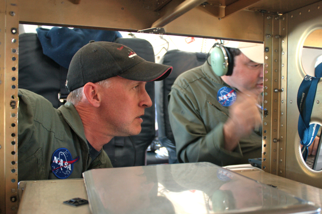
John Sonntag (left), of NASA’s Wallops Flight Facility/URS, and Michael Studinger (right), of NASA’s Goddard Space Flight Center/UMBC, evaluate the Peninsula mission on the fly. Credit: NASA/Kathryn Hansen

PUNTA ARENAS, Chile — Friday evening, IceBridge teams gathered in the hotel conference room to discuss logistics for upcoming flights. First up: weather. The audience watched the animated WRF model, a tool used for flight planning because it tells you what the weather will be like in the next 6-12 hours. On this particular morning, the model showed system after system lined up to pummel Antarctica. “Are we sure this isn’t the WTF model?” a scientists inquired.

Saturday morning, scientist and flight planner John Sonntag arrived at the airport offices with the flight decision. Weather conditions weren’t perfect, but were the best the Antarctic Peninsula had seen in a month. Given that it had been a few days since the last flight and the forecast looked to only worsen in the days ahead, mission planners decided to take the opportunity to fly under the cloud ceiling. The model predicted clear skies below 10,000 feet. “I hope they’re right,” Sonntag said.

The flight planners quickly worked up a modified version of the “Pen 23” flight plan and at 9:23 we took off for the Peninsula.

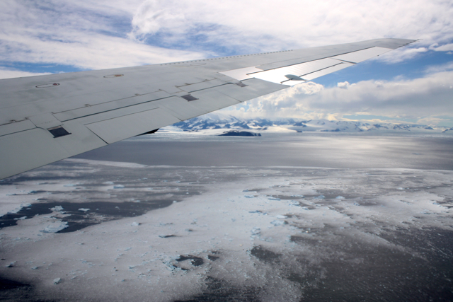
The DC-8 approaches the Antarctic Peninsula. Credit: NASA/Kathryn Hansen

We flew the planned route backward, hitting northern cloud-free regions first. Heading south, we followed the eastern side the “spine” — the crest of a mountain range that extends down the middle of the Peninsula. Unfortunately for stomachs, the spine influences weather patterns and the east side also happened to be the windy, turbulent side. The DC-8 may need to restock the little white bags!

Stomachs also suffered from the dramatic changes in altitude necessary to collect data. The measurements require a relatively consistent altitude, which can be tricky when accessing a glacier behind a rock cliff. But the pilots deftly handled the 7,000-foot-roller coaster flight line to collect data over targets also surveyed during the 2009 campaign.

Glaciers meander through the rocky terrain of the Antarctic Peninsula (right). Credit: NASA/Kathryn Hansen

Targets flown: Hektoria, Drygalski, Crane, Flask and Leppard. Each of these glaciers drain into the Larsen A and B ice shelves which broke apart in 1995 and 2002, respectively. Attlee, Hermes, Lurabee and Clifford. Each of these glaciers drains into Larsen C, which is still intact.

So what? Like a cork in a bottle, ice sheets can plug the neck of a glacier. Remove that ice shelf and the glacier more freely dumps ice into the ocean. Scientists want to keep an eye on how these glaciers continue to respond years and decades after the loss of the shelves. Crane, for example, which feeds into the remnant of Larsen B, shows little sign of slowing down.

Cruising further south, however, we encountered too many clouds so we cut across to the west side of the spine to check out the Fleming Ice Shelf. Clouds there also proved too dense, however, so we turned north back to Punta Arenas. At 8.4 hours, the modified Pen 23 became the shortest flight of the campaign — to the relief of many yellow-faced passengers.

A Three-Hour Car Survey

From Sarah DeWitt, NASA’s Goddard Space Flight Center

November 7, 2010

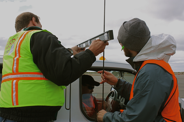
Dave Jordan (NASA ARC), Kyle Krabill (NASA WFF) and Matt Beckley (NASA GSFC) affix a GPS antenna to a pick-up truck for the three-hour Operation IceBridge car survey. Credit: Sarah DeWitt, NASA GSFC.

PUNTA ARENAS, Chile — Today marks the end of Daylight Savings Time in the United States, but the clocks remain unchanged in Punta Arenas. Just 18 hours after setting foot on Chilean soil, I was packing my bag at 5:30 this morning for a DC-8 flight over Pine Island Glacier. I thought that was an exceptionally appropriate first foray into the IceBridge mission, considering that Pine Island is one of the few Antarctic features I know quite well.

Alas, the IceBridge team and I will keep our feet on the ground for at least a few more days while we wait for a replacement airplane part to be delivered from California. The news came over breakfast as the team prepared to fly for a fourth day in a row – a welcome stroke of good luck now put on temporary hold. While the DC-8 team hustled to get the part shipped on the next available plane from L.A., others shifted their focus from the air to the ground.

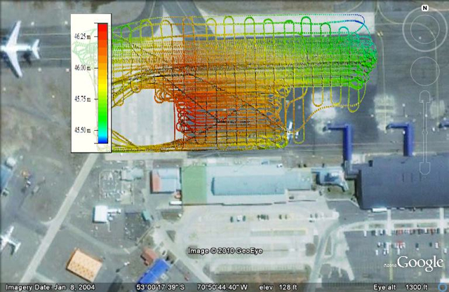
The ground calibration team is really just one person – Kyle Krabill, engineer at NASA’s Wallops Flight Facility. This morning Kyle took advantage of the DC-8 downtime and set out to create a topographic map of the airport ramp. This type of map is called a “car survey” because it involves a three-hour journey criss-crossing the rectangular speck of pavement at a maximum speed of 5 miles per hour. The entire area is only about 200,000 square meters, but it varies in elevation by a factor of about one meter. An accurate elevation map of the ramp is critical for calibrating IceBridge’s airborne instruments. Kyle’s goal is an elevation map with centimeter precision.

He starts his car survey by attaching a GPS antenna to the top of a car. He carefully arranges all of the equipment and passengers before the survey begins, because even a slight difference in weight can affect the measurement. Would-be passengers must commit to the three-hour road trip or be relegated to watch from the sidelines.

Image is courtesy of Kyle Krabill/ATM team

The LVIS 86 Pole Flight

From: Scott B. Luthcke, Geophysicist, NASA’s Goddard Space Flight Center

November 4, 2010, 8:05 p.m. EDT

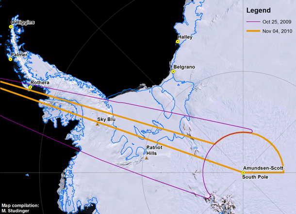
After several days without flights due to unfavorable weather over Antarctica, the Operation Ice Bridge DC-8 is in flight supporting its latest mission. The mission today is the LVIS 86 pole flight. It’s a long 12-hour mission during which the DC-8 will navigate around the South Pole following an arc of -86 deg. latitude at an altitude of 35,000 feet. The South Pole arc will enable NASA’s Land, Vegetation and Ice Sensor (LVIS) to map the surface of the interior of the ice sheet with a 2-kilometer-wide swath, and 25-meter spatial resolution within the swath. This mission will extend the coverage around the pole first collected by LVIS during a 2009 mission. In addition to LVIS, NASA’s Digital Mapping System (DMS) will also be collecting data during this flight. Two other instruments, NASA’s Airborne Topographic Mapper and Kansas University’s MCoRDS radar, typically operate only at lower altitudes, but today both are experimenting with new operational modes and equipment that may allow them to collect data from higher altitudes with LVIS.

The LVIS surface height mapping data provide an important datum to calibrate measurements of ice sheet surface elevation obtained from the Ice Cloud and land Elevation Satellite (ICESat) laser altimeter. ICESat was in a near-polar orbit with the laser altimeter surface profiles densely converging in an arc around the south pole at -86 deg. Therefore, the swath of data LVIS is collecting today, along with that collected in the 2009 pole arc flight, intersects nearly 70 percent of ICESat orbits and provides over a million LVIS and ICESat difference observations for comparison. It’s a unique set of data leveraging the converging satellite tracks around the pole. In addition, the LVIS observations will provide an important datum to monitor long-term interior ice sheet change with respect to current and future near-polar satellite mission data. The DMS and MCoRDS systems complement and enhance the LVIS data by providing high-resolution surface imagery and bedrock topography respectively.

Principal investigator Bryan Blair and scientist Michelle Hofton are running LVIS for today’s mission. Through the magic of technology, lead instrument engineer David Rabine is supporting the mission via xchat while he is on an airplane flying back to the United States after spending the previous three weeks in the field with the instrument. LVIS obtains measurements of surface height using a laser altimeter approach. A laser pulse is transmitted from the instrument, and is reflected back from the surface where the return pulse is recorded. The distance, or range from the instrument to the reflecting surface, is computed as the round trip time of flight of the pulse divided by two (to get the one-way travel time) and then divided by the speed of light. GPS receivers are used to compute the position of the instrument, while the pointing or direction of flight of the laser pulse is determined using instrument orientation data provided by a gyro attitude sensor. The surface elevation for each laser shot can then be computed from these data using the position of the instrument, the direction of the laser pulse travel and the distance or range of the laser pulse travel to the surface.

Credit: NASA/Michael Studinger

Nearly 30 minutes into the flight the excitement ramped up as the pilots prepared to perform the LVIS instrument calibration maneuver. Everyone took their seats and strapped in. A few minutes later the go was given to perform the maneuver and the airplane pitched up and down several times followed by several rolls left and right, giving us all a roller coaster ride. After a few minutes all was clear and we were back to business.

Now, over six hours into the mission we have completed the data collection for the pole arc and are heading back to Punta Arenas, Chile. On the transit back we flew directly over the South Pole! The mission was clearly a success with mostly clear skies and a full data collection from the instruments. Everyone is looking forward to getting on the ground, having a good dinner, and getting rested up for, potentially, another flight tomorrow.

The South Pole Station was easily visible during a flight there on Nov. 4. Credit: Digital Mapping System (DMS) group

Second Weddell Sea Ice Mission and CryoSat Underflight

From: Nathan Kurtz, NASA’s Goddard Space Flight Center/University of Maryland, Baltimore County

Our flight today, Oct. 28, was a partial repeat of a mission conducted last year. The flight was to take place at 1,500 feet along the western edge of the Weddell Sea following the Antarctic Peninsula, turning south and east along the Ronne Ice Shelf, then heading north into the central Weddell Sea. The primary instruments used on this flight were a specially designed suite of laser and radar altimeters for measuring the thickness of the snow and ice underneath.

I began my journey in the cockpit of the NASA DC-8, my first time seeing what all is involved in bringing a large aircraft from the runway into the sky. We took off on schedule flying briefly around the countryside surrounding Punta Arenas, heading back over the airport ramp to calibrate some of the instruments. We then started our push towards the Weddell Sea. Along the way there were spectacular views of the normally cloud enshrouded mountains and glaciers of Tierra del Fuego. Even at an altitude of 18,000 ft the 8,000 ft peaks looked a bit too close for comfort, but the calmness and confidence of the pilots helped rid my mind of any thoughts of catastrophe.

After a couple hours transiting through serene blue skies we spotted the Antarctic Peninsula and began our descent to low altitude. My first ever science flight to the polar regions from two days ago was still fresh in my mind, but the view of the pristine landscape still captivated me. As we passed over the peninsula, there were breathtaking views of jagged brown mountains, bright white snow, sky blue glacier ice, and murky black water all mixed together in a chaotic jumble. I was struck by how truly remote and harsh the world down below was. A place only for well prepared humans and the hardiest of animals. Despite the uninviting look of the land below, I couldn’t help imagining what it might be like to ride a sled or go skiing down some of the mountains.

As we left the peninsula, we passed southward over still waters filled with icebergs, finally entering into the sea ice region to begin our science mission. We first entered into a region of small sea ice floes which had been broken up by wind and waves. The aircraft instruments showed the surface and air temperatures were near the freezing point, probably the reason for the absence of any newly growing ice in the open water areas. As we continued our flight southward we entered the consolidated ice cover of the western Weddell Sea. The region we were flying over today is some of the thickest and most compact ice in the Southern Ocean. The vastness of the sea ice cover became readily apparent as this leg of the journey consisted of miles of ice extending into the horizon in all directions. The area was a mixture of open water, freshly grown ice, smooth areas, rubble fields, ridges, and many other ice types each with intricate geometries reflecting the physical processes which shaped their formation. Towards the end of the peninsula region we turned east following the outline of the Ronne Ice Shelf. Though we couldn’t see it in the distance, evidence of its presence was all around us as numerous icebergs could be seen. The huge size of the icebergs dwarfed the surrounding sea ice, but the icebergs were held steady inside like giants chained into a prison of sea ice.

The sea ice itself looked benign and serene, like a vast unmoving and unchanging landscape. But looks can be deceptive as the aircraft instruments showed temperatures of -10 C and 60+ mph winds outside. Telltale signs of the force of wind and water acting on the ice could be seen in the piled up and crushed ice of the ridges. The wind had also blown the snow into patterns called sastrugi, some of them looked like flowers dotting the landscape. The plane marched on relentlessly throughout the day as miles of sea ice passed below us. The last leg of the science portion of the flight took us underneath the orbit of CryoSat-2, a radar altimeter launched earlier this year by ESA.


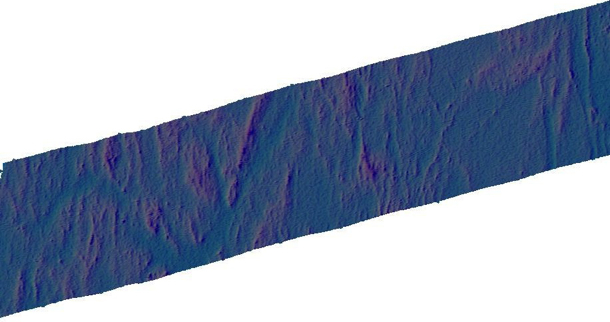
Data from the Airborne Topographic Mapper (ATM) show a swath of sea ice at the time of the CryoSat-2 overpass on Oct. 28, 2010. Data in this image are preliminary. Credit: NASA/ATM Group

One goal of this mission was to collect coincident data between IceBridge and CryoSat-2 for doing intercomparisons between the various altimeter data sets used in cryospheric research. We were a bit ahead of schedule however, so we looped back over portions of our flight line to ensure that we were still collecting data when the satellite crossed over. Finally, as the sun hung began to sink low on the horizon, hundreds of miles above us CryoSat-2 passed silently overhead covering hours of our flight track in a matter of minutes. We continued flying northward a little while longer towards the edge of the ice pack where the ice became less consolidated and more broken up. Our mission finished, we climbed high into the sky and sped back to our temporary home in Punta Arenas.

Image is courtesy of NASA/Jim Yungel

It’s difficult for me to tell much about the ice cover properties from the limited perspective of my human eyes, but memories of the journey will remain with me for a long time to come. An enduring and detailed record has also been written into the hard drives of the IceBridge instrument archives. I and other scientists are eagerly anticipating doing a thorough analysis of the data collected. Hopefully it will tell us more about what we saw today and how this record can be used to enhance our understanding of the climate system.

A Sea Ice Mission Over the Weddell Sea

From: Seelye Martin, University of Washington

The Weddell Sea mission is a pair of lines repeated from last year that extend across the sea ice from the tip of the Antarctic Peninsula to south of Cape Norvegia, and back again (see above). The flight path crosses the tip of the Peninsula, then proceeds on a long straight line to the eastern Weddell Coast, transits down the coast about 200 nautical miles, then transits back, where the sea ice coverage is at 1,500 feet. The primary instruments will be the ATM to measure sea ice freeboard and the snow depth radar for snow depth on the sea ice.

The past five days have been very difficult, in that the weather has been poor, with low clouds or storms over all of our sites. This was stressful for all of us, in that on the previous evening, we would choose a potential target, then get up at 5:00 am local, transit to the airport at 6:30, get to the airport at 7, stare at maps and imagery until 7:30, then consult with the weather office until 8 am. At this point, we would discover the weather was so marginal that we were forced to cancel. But today our forecasts showed a high pressure system over the Weddell Sea, the Chileans said go, so we flew the mission. This is the first in a series of 14 flight plans.

In this mission, our first problem involves the production of accurate weather forecasts. To produce these, we use the following sources: First, the Antarctic Mesoscale Prediction System, which at 00 and 12 UTC, produces a five day forecast at 3-hour increments. This forecast in particular shows the location and height of the cloud layers. Second, the satellite imagery acquired by the NASA Rapidfire system, pressure field forecasts from the European Center for Medium Range Weather Forecasting (ECMWF) and the expertise of Chilean Airport Meteorologists. So what’s the weather like down here? Imagine a circular icecap centered at the South Pole. Under these conditions, there would be a high pressure system over the ice cap, and a series of lows moving around the cap. Now add the Antarctic Peninsula to the icecap, a 4,000-meter-high barrier extending 700 nautical miles toward South America. The lows still rotate around the continent, but now the peninsula causes the lows to stall in the Bellingshausen Sea. This creates the bad weather for the critical region around Pine Island Bay. For the Weddell, this is the first open day since we arrived, and we hope that the mission is free of low clouds.

A second problem involves the avoidance of bird and seal colonies. Low overflights stress the birds and seals; so we need to stay 4,000 feet away from the colonies in the vertical, or 1 nautical mile in the horizontal. We are making every effort to avoid the colonies, many of which are concentrated along our path in the northern peninsula.

A third problem involves the snow depth radar. This is an innovative radar from the University of Kansas, that measures snow depth on sea ice. Last year, the transmit and receive antennas were located adjacent to one another in a fairing attached to the belly of the plane. This year, to improve performance, the receiving antennas were relocated to compartments in the wing roots, one each on each side. The relocation of these antennas involved having a contractor replace the aircraft aluminum panels with a radar transparent material, which is used instead of the aluminum panels, with the antennas mounted behind. The radar is now more sensitive, but it has yet to be tested over sea ice, something we had hoped to do on an earlier flight, so we need to allow for roughly half an hour to take data at low elevations, then analyze it, to make sure that the instrument is working properly before taking data along the line. Having this instrument work will improve the accuracy of the snow depth retrieval. So, weather, penguins, snow radar, all must all be considered for a successful flight.

Here is the timeline of the mission:

0905: Take-off to 33,000 ft, airspeed 450 kts.

1030: We are approaching the peninsula, still at high altitude. Islands are just coming into view, poking up above the clouds, this would be Greenwich Island, straight ahead. Cloud deck is below us, clouds should clear as we cross the peninsula.

1026: Approaching peninsula, high clouds

1051: Passing over the peninsula at 34,000 ft, turbulence shakes plane.

1110: Cleared peninsula, avoided penguin colonies, sea ice is visible straight ahead, dropping our altitude to 1,500 ft. Someone just handed me a paper towel, they are concerned about possible precipitation inside the plane as we descend.

1112: Descending to 1500’ for snow radar calibration.

1113: At 1,500’, approaching sea ice under clouds, snow radar is running

1115: Transiting sea ice edge. small broken floes, sunlight on ice. Surface temp from infrared radiometer is about -2 C. It is warm and sunny out here.

1146: Surface temp as low as -6C, we have good snow. Ice consists of large floes surrounded by open water, occasional nilas (thin ice). Small icebergs visible in distance. This is wonderful flying, horizon visible in all directions, blue sky above. Very different than last year. Gives some faith to the forecast.

1201: Suddenly flying above dense low clouds without breaks.

1208: Dropped to 1,000 ft, still in clouds, some turbulence. I sure hope we fly out of this.

1217: Intermittent cloudiness, now appears to be sharpening up. Pilots do not want to go below 1,000 ft. Now it is really clear again, a whole lot better.

1219: Looks really clear again, good horizon, occasional puffs of clouds, blue sky overhead.

1225: Winds up to 25 kts at right angles to the plane, Langmuir streaks in water. Winds should blow the clouds out of here. Ben reports that the snow radar is working.

1230: Return to 1,500 ft.

1311: Cross-track wind up to 31 kts.

1318: Clouds at horizon, 2 hours to the coast. Ice and blue sky still present.

1350: We are about an hour out from the eastern Weddell coast.

1400: Back into low clouds, some chop, wispy ground fog is back, surface still visible at times, still at 1,500 ft.

1413: Clear again at surface, but overcast overhead. 26 minutes to end of line. Losing the horizon. Turbulence, socked in again, no, I can still see the surface. These cloudy interludes are pretty intermittent. Can sort of see the horizon. Ben reports from early processing of snow radar, 75 cm of snow depth near the peninsula.

1435: Approaching the coast for our turn south. Then about 200 nm on the southern leg, then head back to the peninsula.

1440: Begin turn to the southwest. This is about as close as we will get to the eastern Weddell coast, the British station Halley Bay is off here somewhere, looks like we are on the new trajectory. We are in a heavy haze, but surface is still visible. Good surface visibility.

1530: Just finished traverse along the Brunt ice shelf, very beautiful as we came out from under a cloud deck.

1552: On return track to the tip of the peninsula, good surface visibility but hazy.

1700: Perfect weather on the return line, just heard from pilots that they can finish the line at 1,500 ft. Our low altitude airspeed is 250 knots.

1820: Approaching the peninsula at low altitude, weather remains excellent, beautiful sunset across the Peninsula.

1840: 15 minutes out from waypoint marking the end of the line. We can just about make out the Antarctic Peninsula. Ice is thicker adjacent to the peninsula, this is where the second year ice occurs in the Weddell Sea. The tabular icebergs we are seeing out here probably calf off the Ronne/Filchner Ice Shelves.

1850: Reached waypoint, starting to climb for home, at a sufficient altitude to avoid the penguin colonies.

1900: Cleared the peninsula, at 34,000 ft, headed for home, but encountered 60 kt headwinds.

2120: Landed at Punta Arenas, flight duration was 12.4 hrs.

Welcome to the Operation IceBridge 2010 Antarctic Campaign

From: Michael Studinger, IceBridge project scientist, Goddard Earth Science and Technology Center at the University of Maryland


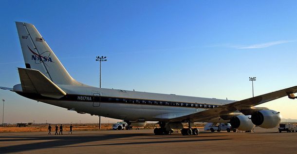
The DC-8, parked outside the hanger at NASA’s Dryden Flight Research Center, is prepared for a instrument test flight. Credit: NASA/Michael Studinger

Oct. 17, 2010

Dryden Flight Research Center, CA — Welcome to our 2010 Antarctic campaign with NASA’s DC-8 Flying Laboratory. For the past two weeks Operation IceBridge teams have been busy installing instruments and sensors onto the DC-8 aircraft here in Palmdale, Calif., at NASA’s Dryden Flight Research Center. Over the next couple of weeks we will fly with the DC-8 over Antarctica to measure changes in thickness of the sea ice surrounding Antarctica and to monitor changes in the thickness of ice sheets and glaciers that cover 98% of the Antarctic continent. 

But before we can go south we have to go through a series of test flights here in California to make sure that all the installed sensors work and to calibrate our science instruments. In order to do this we fly over target sites in the Mojave Desert that we have surveyed on the ground a few days before the test flights. The desert environment that we have selected for our test flights here is very different from the barren land of snow and ice that we will be flying over the next couple of weeks and we all enjoy the low altitude flights over the Mojave Desert, the San Gabriel Mountains and the San Andreas Fault. When the pilots ask you if it would be a problem if the belly of the aircraft is facing the sun you know that you are in the world of research flying. We did a couple of 90 roll maneuvers at high altitude over the Pacific Ocean to calibrate the antennas of the ice-penetrating radar systems that we will use to survey sea ice, glaciers, and ice sheets.

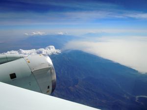
Instrument test flight over the San Gabriel Mountains in California. Credit: NASA/Michael Studinger

The IceBridge teams have enjoyed a few days of work here in warm and sunny California and we are now ready to fly to Punta Arenas in southern Chile, which will be the base of operation for our Antarctic flights. We are looking forward to another successful campaign with exciting new data and spectacular Antarctic scenery.